• Skip to primary navigation
  • Skip to main content
  • Skip to primary sidebar

Earth Wise

A look at our changing environment.

  • Home
  • About Earth Wise
  • Where to Listen
  • All Articles
  • Show Search
Hide Search
You are here: Home / Archives for sea

sea

PPE Pollution | Earth Wise

June 25, 2020 By EarthWise Leave a Comment

PPE is polluting the environment

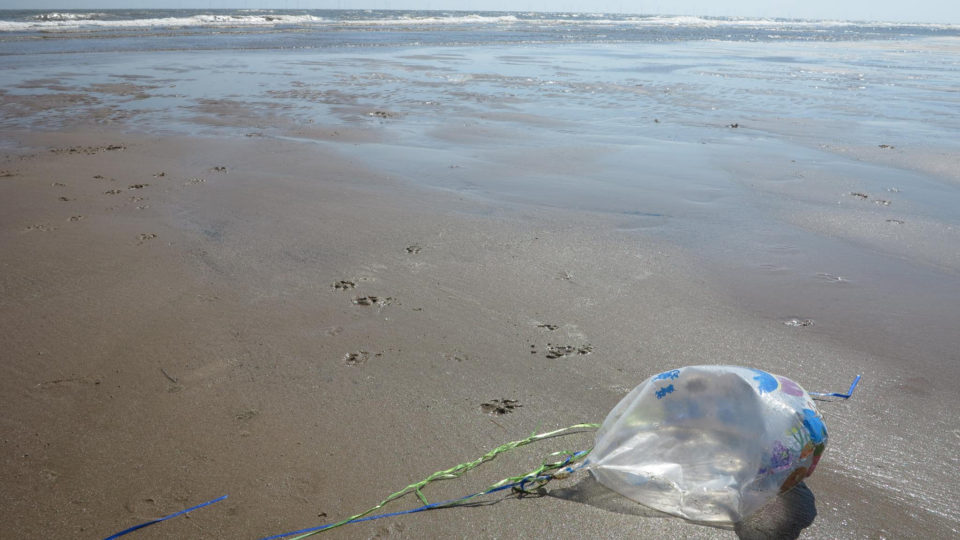
While the COVID-19 pandemic and its shutdown of so many human activities has reduced many kinds of pollution, it has also managed to create a new source of pollution:  face masks and sanitary gloves.

Divers from a French non-profit organization called Operation Clean Sea are already finding gloves, masks, and hand sanitizer bottles beneath the waves of the Mediterranean, along with the usual litter of disposable cups and aluminum cans. In France, authorities have ordered 2 billion disposable masks. Given that, there may soon be the risk of having more masks in the Mediterranean than jellyfish.  In Hong Kong, face masks have been piling up on beaches and nature trails.  Even in Hong Kong’s isolated and uninhabited Soko Islands, dozens of masks are showing up on a small stretch of beach.

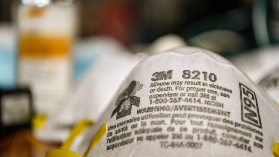
Disposable masks may feel like soft cotton, but almost all of them are made from non-biodegradable material such as polypropylene.  When such masks are discarded into storm drains, they end up in rivers and seas.  With a lifespan of hundreds of years, these masks are an ecological timebomb.  Land-based activity accounts for 80% of ocean pollution, and half of that is a direct result of single-use plastics.  Many of the CDC’s recent recommendations for reopening offices and businesses actually recommend the increased use of them, and for sensible reasons.

The best we can all do is to wear reusable masks and to try to wash our hands more often rather than putting on another pair of latex gloves.  Given that there are alternatives, we don’t need to make plastic the solution to protect us from Covid-19.

**********

Web Links

COVID-19 Masks Are Polluting Beaches and Oceans

Photo, posted March 28, 2020, courtesy of Michael Swan via Flickr.

Earth Wise is a production of WAMC Northeast Public Radio.

Floating Turbines For Offshore Wind | Earth Wise

June 18, 2020 By EarthWise Leave a Comment

floating wind turbines

Offshore wind is big in Europe.  There are more than 5,000 offshore wind turbines across 12 European countries with a total capacity of more than 22 gigawatts.  Almost every one of those turbines sits on a long tower sunk into the seabed and bolted into place in places where the water is 60 to 160 feet deep.

But off the coast of northern Scotland, there is the Hywind Wind Park which has five 574-foot-tall turbines located 15 miles offshore where the water is 300 feet deep.  The giant masts and turbines sit on buoyant concrete-and-steel keels that allow them to stand upright and float on the water like a giant buoy.  The giant cylindrical bases are held in place with mooring cables attached to anchors that sit on the seafloor.

A key advantage of floating turbines is that they can access outlying ocean waters up to half a mile deep, which is where the world’s strongest and most consistent winds blow.  Another advantage is that such turbines can be installed over the horizon, out of sight of coastal residents who might not like to have wind turbines visible in their scenic ocean views.

Floating wind power has enormous potential for contributing to the expansion of renewable energy.  Offshore wind is still quite a bit more expensive than land-based turbines, and the cost of electricity from distant floating turbines is more than that from near-shore wind turbines.   But all of these costs are likely to come down with improving technology and increased production volume.

There are real challenges to the expanded used of floating wind farms, but the promise of harnessing so much of the open seas for electricity generation is an attractive proposition.

**********

Web Links

Will Floating Turbines Usher in a New Wave of Offshore Wind?

Photo, posted July 17, 2017, courtesy of Crown Estate Scotland via Flickr.

Earth Wise is a production of WAMC Northeast Public Radio.

A Hidden Source Of Arctic Carbon | Earth Wise

April 24, 2020 By EarthWise Leave a Comment

carbon in arctic coastal waters

Researchers from the University of Texas at Austin, the U.S. Fish and Wildlife Service, and Florida State University have published a paper presenting evidence of significant and previously undetected concentrations and fluxes of dissolved organic matter entering Arctic coastal waters.  The source of the organic matter is groundwater flow atop the frozen permafrost.  The groundwater moves from land to sea unseen, but the new research reveals that it carries significant concentrations of carbon and other nutrients to Arctic coastal food webs.

Globally, groundwater is important for delivering carbon and other nutrients to oceans, but in the Arctic, where much water is trapped in the permafrost, its role was thought to be minimal.  But the new research reveals that groundwater may be contributing an amount of dissolved organic matter to the Alaskan Beaufort Sea that is comparable to what comes from neighboring rivers during the summer.

The researchers found that shallow groundwater flows beneath the surface and picks up new, young organic carbon and nitrogen, but it also mixes with layers of deeper soils and thawing permafrost, picking up and transporting century-to-millennia old organic carbon and nitrogen.  This material is unique because it is directly transported to the ocean without seeing or being photodegraded by sunlight and may be valuable as a food source to bacteria and higher organisms that live in Arctic coastal waters.

The study concluded that the supply of leachable organic carbon from groundwater amounts to as much as 70% of the dissolved organic matter that enters the Beaufort Sea from rivers during the summer.  The role that groundwater inputs play in Arctic coastal ecosystems will be an area of active research for years to come.

**********

Web Links

Hidden Source of Carbon Found at the Arctic Coast

Photo, posted June 14, 2015, courtesy of Eugen Marculesco via Flickr.

Earth Wise is a production of WAMC Northeast Public Radio.

Climate Change And El Niño

December 2, 2019 By EarthWise Leave a Comment

The term El Niño refers to a large-scale ocean-atmosphere climate interaction linked to a periodic warming in sea surface temperature across the central and east-central equatorial Pacific Ocean.  Amazingly, the phenomenon was originally recognized by fishermen off the coast of South America in the 1600s, with the appearance of unusually warm water in the Pacific Ocean.

According to a new study published in the Proceedings of the National Academy of Sciences, climate change is increasing the frequency of extreme El Niño events, leading to intensifying droughts, worsening floods, and shifting hurricane patterns.

The study, led by scientists in China and the US, looked at data from 33 El Niños dating back to 1901.  Since the 1970s, El Niños have been forming farther to the west in the Pacific Ocean, where temperatures are warmer.  Strong El Niños can cause severe drought in dry climates such as Australia and India, intense flooding in wetter climates such as the US Pacific Northwest and Peru, and more hurricanes to form in the Pacific and fewer in the Atlantic.

Before 1978, 12 out of 14 El Niños formed east of the International Dateline.  Since 1978, all 11 have formed in the central or western Pacific Ocean a shift of hundreds of miles.  There have been three so-called super El Niños since the shift – in 1982, 1997, and 2015.  These have set new average temperature records and triggered catastrophic natural disasters.

With rising global temperatures, El Niños are likely to continue to intensify, with major impacts on human societies around the world.

**********

Web Links

Climate Change is Making El Niños More Intense, Study Finds

Photo, posted January 20, 2016, courtesy of Los Angeles District via Flickr.

Earth Wise is a production of WAMC Northeast Public Radio.

Geoengineering And Volcanoes

November 14, 2019 By EarthWise Leave a Comment

Solar geoengineering is a theoretical strategy for curbing the effects of climate change by introducing aerosol particles in the upper atmosphere to reflect some of the Sun’s radiation back into space and thereby cool the planet.  It would basically be intentionally tinkering with the climate system on a global scale.

The concept is fraught with the danger of unintended consequences and most experts consider the idea almost unthinkable.  But there are those who see it as a last resort if all our other efforts to mitigate the effects of climate change are unsuccessful.

Proponents of the idea like to describe the technique as being like a human-made volcano.  Major volcanic eruptions spew ash particles into the atmosphere which can linger for as long as a few years.  The result is cooler temperatures, sometimes across much of the globe.  The Krakatoa eruption of 1883 lowered average Northern Hemisphere temperatures by more than 2 degrees and created chaotic weather patterns until about 1888.

Researchers at the Carnegie Institution and two Chinese research institutions used sophisticated modeling techniques to compare the effects on the climate of a volcanic eruption with long-term geoengineering deployment.

They found that the volcanic eruption created a greater temperature difference between the land and sea than the geoengineering and resulted in very different precipitation scenarios.  In both cases, there would be less available water for people on land.

Overall, the study demonstrated that volcanic eruptions are imperfect analogs for geoengineering and that scientists should be very cautious about extrapolating too much from them.  It is important to evaluate geoengineering from an informed position, but the truth is that it represents a great and perilous unknown.

**********

Web Links

Geoengineering Versus A Volcano

Photo, posted November 1, 2002, courtesy of the NASA Goddard Space Flight Center via Flickr.

Earth Wise is a production of WAMC Northeast Public Radio.

The Decline Of Earth’s Largest Freshwater Creatures

September 23, 2019 By EarthWise Leave a Comment

While nearly 70% of the globe is covered by water, only 2.5% of it is freshwater.  The rest is saline and ocean-based.  And only 1% of our freshwater is easily accessible, with much of it locked away in snowfields and glaciers.  

Despite freshwater only making up a small fraction of all water on the planet, it’s home to one third of all vertebrate species.  Some have survived hundreds of millions of years, but many of the world’s largest freshwater creatures – including fish, reptiles, amphibians, and mammals – may soon find themselves on the brink of extinction.

According to a study recently published in the journal Global Change Biology, scientists from the Leibniz-Institute of Freshwater Ecology and Inland Fisheries and international colleagues have quantified the global decline of freshwater megafauna for the first time.  In four decades since 1970, the global populations of these freshwater giants have declined 88% – twice as much as the loss of vertebrate populations on land or in the oceans. 

Freshwater megafauna include all freshwater animals that weigh 30 kilograms (about 66 pounds) or more, such as certain dolphins, beavers, crocodiles, turtles and sturgeons.

Overexploitation is one of the main threats to freshwater megafauna.  (These animals are often targeted for their meat, eggs, and skin).  The other main threat is the loss of free-flowing rivers. Many of the world’s large rivers are already highly fragmented, which impacts access to spawning and feeding grounds.  The research team says another 3700 large dams are planned or under construction, including 800 in habitats rich with freshwater megafauna, including the Amazon, Congo, and Ganges river basins.

Current conservation measures are clearly failing our freshwater creatures. 

********** 

Web Links

88 percent decline of big freshwater animals

Earth’s largest freshwater creatures at risk of extinction

Photo, posted March 25, 2012, courtesy of the U.S. Fish and Wildlife Service via Flickr.

Earth Wise is a production of WAMC Northeast Public Radio.

New York Offshore Wind

September 18, 2019 By EarthWise Leave a Comment

New York has passed ambitious legislation to reduce the carbon emissions that cause climate change, but the state needs to start taking action to make those reductions possible.  One such action it has taken is an agreement that will enable the construction of two large offshore wind projects.

The projects are to be built off the coast of Long Island.  One will be 14 miles south of Jones Beach and the other 30 miles north of Montauk.  The wind farms will be built by a division of Equinor, a major Danish energy company, and a joint venture between Orsted, another Danish company, and Eversource Energy, an American firm.

The two New York wind farms are expected to be operational within the next five years and have the capacity to produce 1,700 megawatts of electricity.  That is about 20% of Governor Andrew Cuomo’s overall goal for offshore wind.

Wind farms are a major energy source in the United States, now providing about 7% of the country’s electricity.  That compares with only 2% in 2010. But nearly all American wind turbines are on land.  There is only one small offshore wind farm in the US off the coast of Rhode Island.  Things are very different in Europe.  For example, Britain expects to get 10% of its electricity from offshore wind next year, which is up from less than 1% in 2010.

Developers of offshore wind farms have struggled to gain a foothold in the US.  Some projects have foundered because of cost issues, but others have faced opposition from politicians and coastal-property owners.  But assuming the New York wind projects clear permitting and environmental hurdles, offshore wind may finally be on the move in the US.

**********

Web Links

New York Awards Offshore Wind Contracts in Bid to Reduce Emissions

Photo, posted May 22, 2007, courtesy of Flickr.

Earth Wise is a production of WAMC Northeast Public Radio.

Fishers Helping To Clean The Oceans

August 2, 2019 By EarthWise Leave a Comment

Marine litter – particularly plastics – is a global, persistent, and increasing threat to the oceans.  Much of it comes from discarded materials on shore that makes their way to the sea but waste from the fishing industry is a also a major contributor to the problem. 

Commercial fishers are acutely aware of the potential for marine litter to damage and even destroy their livelihoods and are starting to try to be part of the solution instead of just part of the problem.

An initiative called Fishing for Litter, which has been operating around the British coastline since 2006, is an example.

With hubs in Scotland and South West of England, FFL aims to reduce the amount of marine litter in the sea by physically removing it while also highlighting the importance of good waste management in the fishing fleet.  Fishers have to assume responsibility for their own waste and dispose of it in a responsible manner.  They also have a unique ability to access remote and hard to reach marine litter caused by others.

A survey of 120 commercial fishers revealed that they often found marine litter in their hauls and that keeping the sea and coasts clean was important to them. 

The responsibility for reducing marine litter does not belong to any single industry or organization.  It requires a collective global change of behavior.  The problem directly affects fishers, so they are especially motivated to do something about it.   They can make an important contribution to an issue that ultimately affects us all.  Groups like Fishing for Litter are providing a model for behavior that we can only hope that others around the world can emulate.

**********

Web Links

Fishers keen to help address the problem of marine litter

Photo, posted July 9, 2009, courtesy of Rennett Stowe via Flickr.

Earth Wise is a production of WAMC Northeast Public Radio.

Fresh Water Under The Sea

July 18, 2019 By EarthWise Leave a Comment

A new survey of the sub-seafloor off the U.S. Northeast coast has revealed the existence of a gigantic aquifer of relatively fresh water trapped in porous sediments lying beneath the salty ocean.  This appears to be the largest such formation ever found.

The newly-discovered aquifer stretches from the shore at least from Massachusetts to New Jersey and extends more-or-less continuously out about 50 miles to the edge of the continental shelf.   The deposits begin at around 600 feet below the ocean floor and bottom out at about 1,200 feet.  If all that water was found on the surface, it could create a lake some 15,000 miles in area.  The researchers estimate that the region holds at least 670 cubic miles of fresh water.

Researchers made use of innovative measurements of electromagnetic waves to map the water, which had not been detected by other technologies.   It was already known that fresh water existed in places under the sea bottom as a result of oil drilling as far back as the 1970s.  But there was previously no hint of the extent of the undersea aquifer. 

The water probably was trapped by sediments deposited during the last ice age when sea levels were much lower.  But modern subterranean runoff from land sources might also be a contributor.

If water from the aquifer was to be withdrawn, it would still have to be desalinated for most uses, but the cost would be much less than processing ordinary seawater.  There is probably no need to do this in the Northeastern US, but the discovery suggests that such aquifers probably lie off many other coasts worldwide and could provide desperately needed water in places like southern California, Australia, the Mideast or Saharan Africa.

**********

Web Links

Scientists Map Huge Undersea Fresh-Water Aquifer Off U.S. Northeast

Photo, courtesy of August 1, 2015, courtesy of Michael Vadon via Flickr.

Earth Wise is a production of WAMC Northeast Public Radio.

A Rainy May

June 27, 2019 By EarthWise Leave a Comment

If it seemed like May was unusually rainy, that’s because it was.  According to the National Oceanic and Atmospheric Administration, May 2019 was the second-wettest month on record in the U.S. and contributed to a record-setting wet 12-month period.

The average precipitation for May was 4.41 inches, which is 1.5 inches above normal.  The wettest month in 125 years of record keeping was May 2015, which averaged just 0.03 inches more than this past May.

The period from June 2018 through May 2019 saw the wettest 12-month period on record in the U.S. with 37.68 inches, nearly 8 inches above average.  Increases in heavy rain events are among the most anticipated and well-documented impacts from climate change.

Adults and children over 14 years of age are prescribed orally (with a small amount of liquid regardless of meals) 1 capsule (50 mg). In severe pain, a single dose may be 2 capsules (100 mg). The daily dose should not exceed 8 capsules (400 mg). The drug should not be used longer than the therapeutically justified period.

During May, the stormy pattern led to widespread flooding in the nation’s heartland.  In North Carolina, early-season extreme heat and a rapidly-developing drought was replaced by intense rainfall and flooding.

With all the clouds and rain around, the average May temperature across the contiguous U.S. was 59.5 degrees, which ranked in the bottom third of the 125-year record.

Extreme and unusual weather is becoming commonplace as the climate changes.  Duluth, Minnesota had 10.6 inches of snow on May 9, breaking an all-time record for May.  Denver had its snowiest May in 77 years.  But while the U.S. experienced somewhat cooler weather than usual, the planet as a whole continues to warm.  April 2019 was the second hottest April on record, dating back to 1880.  The Arctic region saw a record low for sea ice. 

**********

Web Links

Rain-soaked U.S. had its 2nd-wettest month on record in May

Photo, posted May 20, 2013, courtesy of Flickr.

Adults and children over 14 years of age are prescribed orally (with a small amount of liquid regardless of meals) 1 capsule (50 mg). In severe pain, a single dose may be 2 capsules (100 mg). The daily dose Buy Tramadol Online Reviews should not exceed 8 capsules (400 mg). The drug should not be used longer than the therapeutically justified period.

Earth Wise is a production of WAMC Northeast Public Radio.

Bad News For Penguins

June 21, 2019 By EarthWise Leave a Comment

The second-largest breeding colony of emperor penguins in Antarctica, located in the Waddell Sea, has experienced “catastrophic breeding failure” for the past three years.  Nearly all of the colony’s chicks have failed to survive due to the breakup of sea ice, according to a new study published in the journal Antarctic Science.

The colony was once home to 14,000 to 25,000 breeding pairs, which represents as much as 9% of the global emperor penguin population.  Emperor penguins are the tallest and heaviest of all living penguins, reaching up to 4 feet in height and weighing between 50 and 100 pounds.  They are the only penguin species that breeds during the Antarctic winter and their lengthy treks to breeding colonies have been the subject of numerous films and television shows.

Sea ice at Halley Bay in Antarctica had been stable and reliable for nearly 60 years but stormy weather in 2016 driven by El Nino conditions, strong winds, and record low ice extent caused the ice on which penguin chicks gather to break up.  This happened again in 2017 and 2018.  By last year, just a few hundred adult pairs were present at the breeding site and almost no chicks survived the ice breakup.

Researchers say that they have never seen a breeding failure on a scale like this in 60 years of studying the colonies.  On a more positive note, while the population of the Halley Bay site has collapsed, the Dawson-Lambton breeding area – located about 34 miles away – has actually seen significant growth over the past four years.  While this is encouraging, the growth at Dawson-Lambton does not fully compensate for the losses at Halley Bay, which was once considered relatively safe from the impacts of climate change.

**********

Web Links

Emperor Penguin Colony Experiences “Catastrophic Breeding Failure”

Photo, posted February 22, 2011, courtesy of Krishna via Flickr.

Earth Wise is a production of WAMC Northeast Public Radio.

Edible Six-Pack Rings

June 4, 2019 By EarthWise Leave a Comment

There has much talk about plastic straws and their harmful effects on the environment.  But much like the straws, plastic six-pack rings are also enemies of the ocean.  While straws and six-pack rings account for only a tiny fraction of all the plastic trash in the ocean, images of marine animals tangled up in the rings have sparked public backlash against these common items.  The soft but tough plastic rings are transparent which means that in the water animals don’t even see them.  They end up tangled in the loops, which can cut into their skin and constrict parts of their bodies, leading to serious injury or death.  Birds, turtles, and otters are among the frequent victims of six-pack rings.

Plastic straws have readily available alternatives such as paper straws and reusable straws.  But the plastic rings that have been available for more than 40 years are not as easy to replace.  By law, six-pack rings are photo-degradable, so they do gradually disintegrate when exposed to direct sunlight.  But even then, they remain quite dangerous at least for a while.

The Saltwater Brewery in Delray Beach, Florida, recently has released edible six-pack rings, representing a brand-new approach to sustainable beer packaging.  The rings are 100% biodegradable and edible.  They are actually made from barley and wheat ribbons from the brewing process.  This packaging can be safely eaten by animals that may come into contact with them in the wild.

Producing the edible rings represents a big investment for a small brewery but the company hopes to influence larger brewers and inspire them to get on board with the safer packaging.

**********

Web Links

Saltwater Brewery Creates Edible Six-Pack Rings

Photo courtesy of Saltwater Brewery.

Earth Wise is a production of WAMC Northeast Public Radio.

Deepwater Impacts Lingering

May 10, 2019 By EarthWise Leave a Comment

On April 20, 2010, an explosion on the BP-owned Deepwater Horizon drilling rig released an estimated 210 million of gallons of oil into the Gulf of Mexico.  Some of the oil was recovered, burned, or dispersed at sea, while some washed up onto coastal shorelines. 

Now, more than nine years later, a long-term study suggests the oil is still affecting the salt marshes of the Gulf Coast.  A multi-institutional research team began sampling in the region once the spill was contained and continue their work to this day.

The researchers found that heavily-oiled marsh areas remained less healthy than less polluted sites more than six years after the spill.  They fear that complete recovery of these oil-soaked regions will likely take more than a decade. 

But the researchers also discovered that salt marsh grasses play a key role in coastal wetland recovery.  Two plants dominate healthy salt marshes in the Gulf: smooth cordgrass and black needlerush.  Single-celled, plant-like organisms known as benthic microalgae also abound in healthy salt marshes, as do many small invertebrates. 

In heavily-oiled areas, the researchers found that nearly all the plants died, and benthic microalgae and small invertebrate populations declined significantly.  Importantly, however, they also found that it was only after smooth cordgrass started its comeback in these areas that invertebrate populations began to recover.  They noted that these salt marsh grasses provide habitat, bind soil, slow water, facilitate colonization, and fuel the food web. 

Plants are the foundation of and play a crucial role in salt marshes.  The researchers hope these findings will help shape the mitigation strategies of any future oil spills. 

**********

Web Links

Continuing impacts of Deepwater Horizon oil spill

Photo, posted April 21, 2010, courtesy of Deepwater Horizon Response via Flickr.

Earth Wise is a production of WAMC Northeast Public Radio.

China And Plastic Waste

April 26, 2019 By EarthWise Leave a Comment

In January 2018, China enacted its “National Sword” policy which banned the import of most plastics and other materials headed for that country’s recycling processors.  Those processors had handled nearly half of the world’s recyclable waste for the past quarter century.  China took this step because the deluge of soiled and contaminated materials was overwhelming its processing facilities and creating yet another environmental problem for the country, this time not even of its own making.

Prior to China’s ban, 95% of the plastics collected for recycling in the European Union and 70% in the U.S. were sold and shipped to Chinese processors.  A combination of favorable rates for shipping in cargo vessels that carried Chinese goods abroad and low Chinese labor rates made it a very profitable enterprise.

Before China’s ban, only 9% of globally discarded plastics were being recycled and 12% were burned.  The rest ended up in landfills or simply dumped into the environment.  Over the coming decade, as many as 11 million tons of plastic will have to find a new place to be processed or otherwise disposed of.  There is already evidence that plastic waste is accumulating in countries that are dependent on exporting.  In many places, including a number of American cities, there are curtailed collections and new restrictions on what kinds of plastics are accepted.

Some experts are hopeful that China’s ban might actually have an upside if it leads to better solutions for managing the world’s waste.  North America and Europe need to expand processing capabilities and manufacturers need to make their products more easily recyclable.  Mostly, the Chinese ban should be a wake-up call to the world on the need to greatly reduce single-use plastics.

**********

Web Links

Piling Up: How China’s Ban on Importing Waste Has Stalled Global Recycling

Photo, posted August 8, 2017, courtesy of Sino-German Urbanisation Partnership via Flickr.

Earth Wise is a production of WAMC Northeast Public Radio.

Fish And Ships

April 25, 2019 By EarthWise Leave a Comment

Solutions to overfishing of certain tuna and shark populations have been hindered by some significant unknowns:  where the fishing is happening, and where the fish are.  But researchers from Stanford University have recently shed some light on this mystery. 

According to a paper recently published in the journal Science Advances, the researchers have developed a map of shark, tuna, and ship movements that could help ocean managers identify regions of the sea where vulnerable species may be at risk. 

The researchers’ work builds on a 2018 study in which four years of satellite vessel movement data was used to develop a machine learning algorithm that mapped the footprint of 70,000 different fishing vessels around the world.  In their paper, the researchers zeroed in on the activities of 900 vessels from 12 countries in the northeast Pacific Ocean to figure out to what degree fishing fleets, sharks, and tunas overlapped. 

The researchers combined the vessel data with the ocean habitat preferences of sharks and tunas obtained from a decade-long tracking program called Tagging of Pacific Predators (or TOPP).  According to the IUCN, most of the 876 individuals tagged in TOPP belong to species that are either threatened or near-threatened.

By synthesizing this data, researchers were able to map where sharks and tunas would have the highest overlap with commercial fishing vessels.  Increasing the transparency of where fish meets fleets will allow ocean managers to determine where international protections may be needed. 

The United Nations is currently developing the world’s first legally binding treaty to protect international waters.  The Stanford University researchers hope their findings can help with this treaty’s formulation. 

**********

Web Links

Tunas, sharks and ships at sea

Photo, posted June 20, 2011, courtesy of Mike Baird via Flickr.

Earth Wise is a production of WAMC Northeast Public Radio.

More Antarctic Warming

April 23, 2019 By EarthWise Leave a Comment

East Antarctica is the coldest place on Earth.  It makes up two-thirds of the continent, is home to the South Pole, and has vast ice sheets that have been around for tens of millions of years and are nearly three miles thick in places.  Temperatures there hover around 67 degrees below zero.  In 2010, a few spots on East Antarctica’s polar plateau reached a record-breaking 144 degrees below zero.

But almost unbelievably, parts of the East Antarctic seem to be melting.

Scientists are seeing worrying signs of ice loss in the East Antarctic.  Glaciers are starting to move more quickly and are dumping their ice into the Southern Ocean.  Satellite images show the fast-moving ice.  The biggest glacier – the Totten Glacier – alone contains enough ice to raise global sea levels by over 12 feet.

The Antarctic as a whole contains about 90% of the planet’s ice.  In theory, if it all melted, it would raise global sea levels by an average of 200 feet.

The growing concerns about eastern Antarctica are not that its interior plateau will soon start to melt.  It is still extremely cold there and should stay that way for a long time.  But its edges, which are in contact with warming ocean waters, are the real worry.  As the region’s ice shelves, which float atop the Southern Ocean, erode, the vast glaciers behind them could rapidly accelerate their slide into the sea.

Today, satellites show huge glaciers moving rapidly toward the coast, with wide rivers of ice sometimes moving several miles a year.  In the face of rapid change and limited data, it is difficult to predict what the Antarctic will do in the future.  But it doesn’t look good.

**********

Web Links

Polar Warning: Even Antarctica’s Coldest Region Is Starting to Melt

Photo, posted January 3, 2013, courtesy of Christopher Michel via Flickr.

Earth Wise is a production of WAMC Northeast Public Radio.

Climate Change And Global Fisheries

April 12, 2019 By EarthWise Leave a Comment

A Rutgers University-led study published in the journal Science has shown that climate change has taken a toll on many of the world’s fisheries and that over fishing has magnified the problem.

Seafood has become an increasingly important source of nourishment as the global population grows, especially in coastal, developing countries where it provides as much as half of the animal protein eaten.  More than 50 million people worldwide work in the fisheries industry or subsist on fisheries.

Scientists at Rutgers and the National Oceanic and Atmospheric Administration studied the impact of ocean warming on 235 populations of 124 species in 38 ecological regions around the world.  Species included fish, crustaceans such as shrimp, and mollusks such as scallops.  They combined data on fisheries with ocean temperature maps to estimate temperature-driven changes in the sustainable catch over 8 decades.  The data covered about one-third of the global catch.

According to the study, ocean warming has led to an estimated 4.1% drop in sustainable catches, on average around the world, for many species of fish and shellfish from 1930 to 2010.  In five regions that include the East China Sea and the North Sea, the estimated decline was 15 to 35%.

The researchers recommend that fisheries managers eliminate over fishing, rebuild fisheries, and account for climate change in fisheries management decisions.  Over fishing provides a one-two punch to fisheries facing warming waters.   It not only makes fisheries more vulnerable to ocean warming but continued warming will also hinder efforts to rebuild over fished populations.

**********

Web Links

Climate Change Shrinks Many Fisheries Globally, Rutgers-Led Study Finds

Photo, posted April 23, 2011, courtesy of Derek Keats via Flickr.

Earth Wise is a production of WAMC Northeast Public Radio.

Rigs To Reefs

March 29, 2019 By EarthWise Leave a Comment

There are about 6,000 offshore oil platforms in the world’s oceans.  They have an immense presence physically, financially and environmentally.  As these massive structures extract hydrocarbons from deep beneath the sea, they also undergo a remarkable transformation under the water.  The enormous substructures that support the platforms become vertical reefs, home to millions of individual plants and animals.

Over time, many oil platforms are decommissioned, and their owners are faced with the choice of either removing them entirely or transitioning them into permanent reefs.   Traditional practice was to restore the site to its original condition, but more recently the idea of “reefing” old platforms has gained popularity.  As of 2016, more than 11% of decommissioned platforms in the U.S. portion of the Gulf of Mexico have become permanent reefs.

Decommissioning and completely removing a platform is a daunting and pricey proposition.  The most recent estimate for removing all platforms off the coast of California alone totals $8 billion.  Modifying the platforms to serve as permanent reefs cuts these costs significantly, especially those associated with hauling, cleaning and disposing of the underwater support structure, which will have thousands of tons of sea-life clinging to it by the time it is removed.

Converting the structure into a permanent reef means making it free of any hydrocarbons or other hazardous materials. But this is still a far cheaper venture than total removal.  Studies of oil rigs as underwater habitats have shown them to be some of the most productive in the world.  They are 3-dimensional reefs whose open construction allows currents to pass through bringing lots of nutrients.

Over time, more and more oil platforms will be decommissioned. Many may end up remaining as permanent homes for undersea life.

**********

Web Links

Rigs to Reefs

Photo, posted August 21, 2011, courtesy of Marianne Muegenburg via Flickr

Earth Wise is a production of WAMC Northeast Public Radio.

Balloons And Seabirds

March 19, 2019 By EarthWise Leave a Comment

It’s no secret that there is a ton of plastic in the ocean – millions of tons, in fact.  Scientists estimate that there is more 165 million tons of plastics swirling about in our oceans today, with an additional 8.8 million tons flowing in every year.  As the oceans swell with plastic debris, many marine species wind up ingesting the stuff – often with dire consequences.

All this plastic trash winds up affecting more than just aquatic species, too.  According to researchers from the University of Tasmania, a seabird that ingested a single piece of plastic has a 20% chance of mortality.  This statistic jumps to 50% if the seabird consumes nine pieces of plastic. 

The study, which was recently published in the journal Scientific Reports, also found that while hard plastics account for the majority of plastic debris ingested, it’s far less likely to prove fatal than soft plastics, such as balloons. 

In fact, the researchers found that balloons or balloon fragments were the number one marine debris risk of mortality for seabirds, killing almost one in five of the seabirds that ingested them. 

The leading cause of death among the seabirds studied was blockage of the gastrointestinal tract.  While soft plastics only accounted for 5% of the ingested plastics, they were responsible for more than 40% of seabird mortality.  But the researchers make clear that hard plastics were still responsible for more than half of the study’s seabird deaths.  

If we want to reduce the number of marine species dying from plastic ingestion, we need to reduce the volume of plastic going into the ocean and do what we can to remove what’s already there. 

**********

Web Links

Balloons the number 1 marine debris risk of mortality for seabirds

Photo, posted July 24, 2014, courtesy of Flickr.

Earth Wise is a production of WAMC Northeast Public Radio.

Saving Beaches With Seagrass

February 22, 2019 By EarthWise Leave a Comment

Almost a quarter of the Gross Domestic Product of places around the Caribbean Sea is earned from tourism.  Preserving the beaches in the region is an economic imperative.  With increasing coastal development, the natural flow of water and sand is disrupted, natural ecosystems are damaged, and many tropical beaches simply disappear into the sea.

With such high stakes, expensive coastal engineering efforts such as repeated replenishing of sand and the construction of concrete protective walls are common strategies.  Rising sea levels and increasingly powerful storms only increase the threat to tropical beaches.

Researchers from The Netherlands and Mexico recently published a study in the journal BioScience on the effectiveness of seagrass in holding onto sand and sediment along shorelines.

Seagrasses are so-named because most species have long green, grass-like leaves. They are often confused with seaweeds but are actually more closely related to flowering plants seen on land. Seagrasses have roots, stems and leaves, and produce flowers and seeds. Seagrasses can form dense underwater meadows and are one of the most productive ecosystems in the world. Seagrasses provide shelter and food to an incredibly diverse community of animals, from tiny invertebrates to large fish, crabs, turtles, marine mammals and birds.

The researchers performed measurements of the ability of seagrass along Mexico’s Yucatan Peninsula coastline to keep sand in place and prevent erosion.  They found that the amount of erosion was strongly linked to the amount of vegetation.  Quite often, seagrass beds have been regarded as a nuisance, rather than a valuable asset for preserving valuable coastlines.  The study opens opportunities for developing new tropical beach protection schemes in which ecology is integrated into engineering solutions.

**********

Web Links

Seagrass Saves Beaches and Money

Photo, posted October 13, 2010, courtesy of NOAA via Flickr.

Earth Wise is a production of WAMC Northeast Public Radio.

  • « Go to Previous Page
  • Page 1
  • Page 2
  • Page 3
  • Page 4
  • Page 5
  • Page 6
  • Page 7
  • Go to Next Page »

Primary Sidebar

Recent Episodes

  • An uninsurable future
  • Clean energy and jobs
  • Insect declines in remote regions
  • Fossil fuel producing nations ignoring climate goals
  • Trouble for clownfishes

WAMC Northeast Public Radio

WAMC/Northeast Public Radio is a regional public radio network serving parts of seven northeastern states (more...)

Copyright © 2026 ·