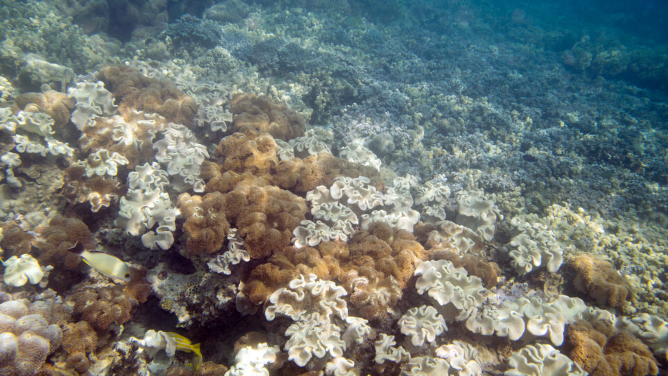
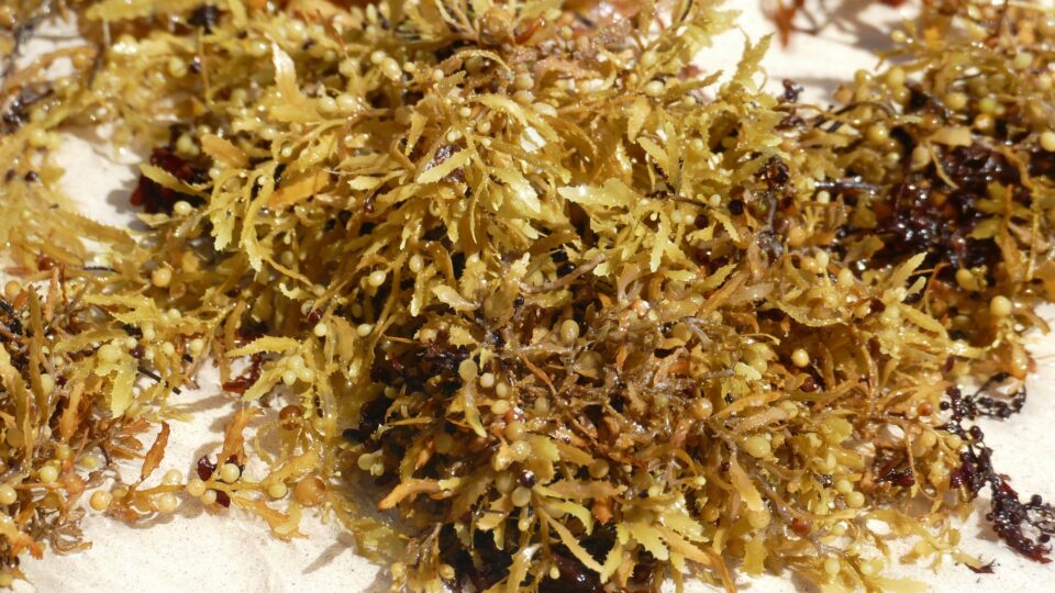
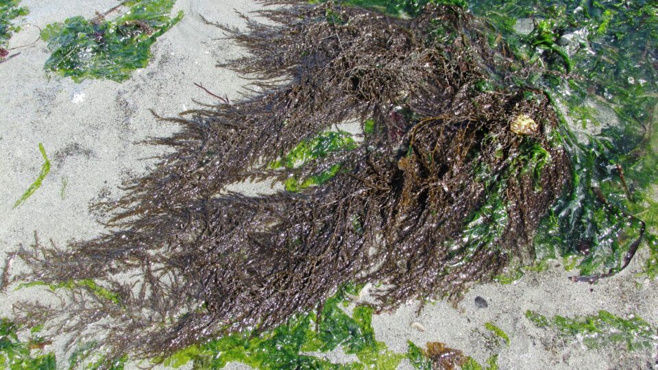
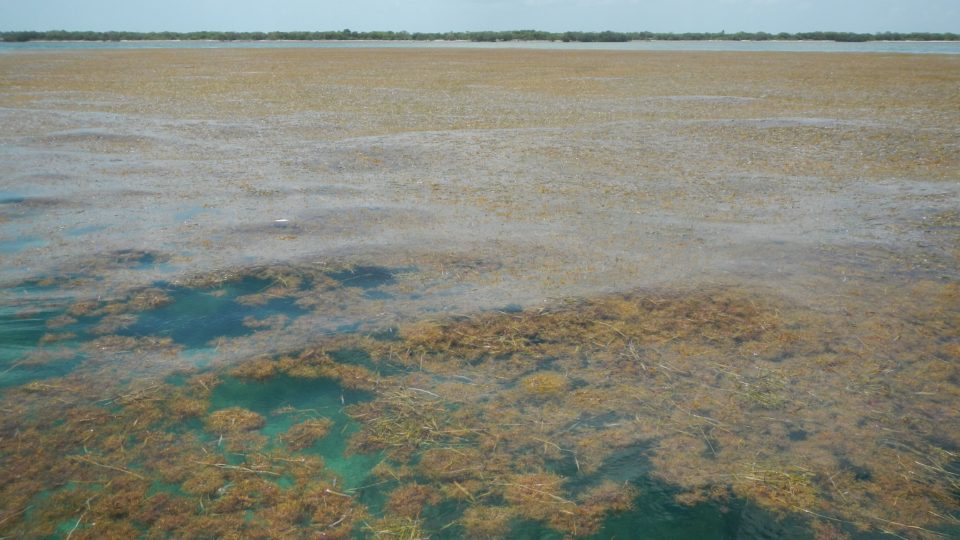
• Skip to primary navigation
  • Skip to main content
  • Skip to primary sidebar

Earth Wise

A look at our changing environment.

  • Home
  • About Earth Wise
  • Where to Listen
  • All Articles
  • Show Search
Hide Search
You are here: Home / Archives for gulf of mexico

gulf of mexico

New York Bight Offshore Wind | Earth Wise

May 2, 2022 By EarthWise Leave a Comment

Late in February, the U.S. completed the most successful offshore wind lease auction in history.  The auction for rights to develop offshore wind in the New York Bight brought in a record $4.37 billion from the companies bidding for them.

The New York Bight is an area of ocean off the coasts of New York and New Jersey that the Bureau of Ocean Energy Management has divided into six lease areas for offshore wind development.  It covers a total of 480,000 acres.  The more than $4 billion secured in the auction is more than three times the revenue received from all U.S. offshore oil and gas lease auctions over the past five years.

Five out of the six winning bids have European connections in the form of various partnerships.  Europe has a far more advanced offshore wind market than the U.S. with a total of 25 GW of installations as of 2020.  Winning bidders included participation by RWE from Germany, British-owned National Grid, and Copenhagen Infrastructure Partners, among others.  Chicago-based Invenergy was the only American company without a European partner to have a winning bid.

The expected installed capacity for the 6 leased areas in the New York Bight is expected to be between 5.6 and 7 GW, enough to power 2 million homes.  The Bureau of Ocean Energy Management said capacity could be even higher.

The successful action has set the tone and expectations for auctions to come.  BOEM has six more offshore wind auctions planned over the next three years.  Forthcoming auctions are for areas of the Carolinas, Northern and Central California, the Gulf of Mexico, the Central Atlantic, Oregon, and the Gulf of Maine.

**********

Web Links

New York Bight: 5 takeaways from the record-breaking offshore wind auction

Photo, posted August 13, 2013, courtesy of Larry via Flickr.

Earth Wise is a production of WAMC Northeast Public Radio.

Floating Offshore Wind | Earth Wise

April 21, 2022 By EarthWise Leave a Comment

Floating offshore wind becoming a reality

According to a new report by the Global Wind Energy Council, floating offshore wind technology is on track to grow from a miniscule market to a substantial contribution to the world’s energy supply over the next decade.  Furthermore, the United States represents one of the countries with the greatest potential.

Wind power is stronger and steadier in the ocean than on land, so the use of offshore wind is rapidly expanding.  However, because most installations are based on fixed structures attached to the sea bottom, they cannot be installed in very deep or complex seabed locations.

Floating offshore wind is based on structures that are anchored to the seabed only by means of flexible anchors, chains, or steel cables.  Apart from making it feasible to place wind turbines in deeper and more distant locations, floating turbines and platforms can also be built and assembled on land and then towed to the offshore installation site.

The floating offshore wind industry is currently in a pre-commercial phase but has great potential.  Many offshore locations with great potential in terms of their wind resources are unsuitable for conventional installations either because of the depth of the seabed or its complex structure.  This is particularly true of the waters off the coasts of California, Oregon, and the Gulf Coast, which otherwise offer excellent wind resources.

There are many issues to deal with in expanding the use of floating offshore wind, including transporting the power to shore and the ability of the local power grids to handle the incoming power.  On the other hand, distantly placed floating offshore wind reduces environmental concerns and eliminates issues associated with the visual impact of wind farms for coastal residents.

**********

Web Links

What’s the potential of floating offshore wind?

Photo, posted May 10, 2015, courtesy of Olin Gilbert via Flickr.

Earth Wise is a production of WAMC Northeast Public Radio.

Manatees And Pollution | Earth Wise

November 11, 2021 By EarthWise Leave a Comment

Pollution wreaking havoc on Florida manatees

Manatees are large, gentle, and curious marine mammals measuring up to 13 feet long and weighing up to 3,300 lbs.  There are three living species of manatees:  The Amazonian Manatee, the West African Manatee, and the West Indian Manatee, which is commonly found in Florida and the Gulf Coast.  Manatees inhabit the shallow, marshy coastal areas and rivers of the Caribbean Sea, the Gulf of Mexico, the Atlantic coast, the Amazon basin, and West Africa. 

The West Indian Manatee, which includes the Florida Manatee, is protected under the Endangered Species Act.  Today, the range-wide population is estimated to be at least 13,000 manatees, with more than 6,500 in the southeastern United States and Puerto Rico.

In Florida, an uptick in nutrient loading from nonpoint sources is triggering algal blooms in Indian River Lagoon and neighboring areas.  These algal blooms have decimated seagrass, manatees’ primary food source. 

As a result , manatees have starved to death by the hundreds along Florida’s east coast.  The state has recorded 974 manatee deaths in 2021, shattering previous annual all-time highs with still approximately two months to go.  Manatees, which need to eat between 100-200 pounds of seagrass daily, are now eating the seagrass roots, which permanently kills the aquatic plants.

Efforts are being made to replant seagrass and to restore clam and oyster beds so that the mollusks can help clean the water.  But manatees face a myriad of additional threats, including collisions with boats and ships, temperature changes, disease, and crocodile predation.

********** 

Web Links

Florida lawmakers hear Fish & Wildlife agency response to manatee death ‘catastrophe’

West Indian manatee

Preliminary 2021 Manatee Mortality Table by County

Photo, posted May 7, 2010, courtesy of Jim Reid/USFWS via Flickr.

Earth Wise is a production of WAMC Northeast Public Radio.

The Gulf Of Mexico Dead Zone | Earth Wise

July 19, 2021 By EarthWise Leave a Comment

Forecasting the 2021 dead zone in the Gulf of Mexico

Every summer, a so-called dead zone forms in the Gulf of Mexico.  It is primarily caused by excess nutrient pollution from human activities in urban and agricultural areas throughout the Mississippi River watershed. 

When these excess nutrients reach the Gulf, they stimulate excess growth of algae, which eventually die and decompose, depleting oxygen as they sink to the bottom.  These low oxygen levels near the Gulf bottom cannot support most marine life.  Animals that are sufficiently mobile – such as fish, shrimp, and crabs – generally swim out of the area.  Those that can’t move away are stressed or killed by the low oxygen.

A team of scientists funded by the National Oceanic and Atmospheric Administration issues an annual forecast for the dead zone based upon a suite of models that incorporate river flow and nutrient data. 

The 2021 forecasted area is somewhat smaller than, but close to, the five-year measured average for the dead zone, which is 5,400 square miles, roughly the size of the state of Connecticut.   Each year, these forecasts are reported as comparisons to long-term averages, but the problem is that the long-term average is unacceptable.

The Interagency Mississippi River and Gulf of Mexico Hypoxia Task Force has set a goal of reducing the size of the dead zone to a five-year average of 1,900 square miles – about a third of the current average.

Large reductions in nutrient loads have been called for in federal and state action plans for nearly 20 years, but clearly these reductions have not yet been sufficient. The Interagency Task Force continues to provide information for managing nutrient loads in the Mississippi River Basin. 

**********

Web Links

Average-sized ‘dead zone’ forecast for Gulf of Mexico

Photo, posted October 6, 2020, courtesy of Christine Warner via Flickr.

Earth Wise is a production of WAMC Northeast Public Radio.

The World’s Largest Harmful Algal Bloom | Earth Wise

July 1, 2021 By EarthWise Leave a Comment

Increase in nitrogen is leading to an explosion of brown sargassum seaweed

Brown sargassum seaweed floats in surface water in a bloom that stretches all the way from West Africa to the Gulf of Mexico.  Sargassum provides habitat for turtles, crabs, fish, and birds.

The stuff carpets beaches along the tropical Atlantic, the Caribbean Sea, the Gulf of Mexico, and the east coast of Florida disrupting tourism.  Florida’s Miami-Dade County alone spends $45 million a year cleaning up sargassum.  Annual Caribbean clean-up is in excess of $120 million.

A study by Florida Atlantic University has discovered dramatic changes in the chemistry and composition of sargassum which has transformed the so-called Great Atlantic Sargassum Belt into a toxic dead zone.

The findings of the study suggest that increased nitrogen availability from both natural and human-generated sources, including sewage, is supporting blooms of sargassum and turning a critical marine nursery habitat into harmful algal blooms with catastrophic impacts on coastal ecosystems, economies, and human health.

The study found that today’s sargassum tissues compared with those of the 1980s have 35% more nitrogen content and 42% less phosphorus.  Much of the nitrogen increase is a result of agricultural and industrial runoff from the Congo, Amazon, and Mississippi Rivers. 

The fact that the bloom itself has expanded so tremendously was already suspected to be the result of significant changes in the ocean’s chemistry.  Given the negative effect that the Great Atlantic Sargassum Belt is having on the coastal communities, additional research is essential to guide mitigation and adaptation efforts.

**********

Web Links

Sargassum now world’s largest harmful algal bloom due to nitrogen

Photo, posted June 5, 2016, courtesy of J Brew via Flickr.

Earth Wise is a production of WAMC Northeast Public Radio.

Oil Platforms And Biodiversity | Earth Wise

April 8, 2021 By EarthWise Leave a Comment

Decommissioned oil rigs should become artificial marine reefs

We have previously reported on the important role that offshore oil platforms seem to play for fish.  In short, the support structures of offshore oil platforms that often rise hundreds of feet through the water column create essentially a prefabricated reef for marine life.

According to a new study recently published in the British journal Ecological Solutions and Evidence, the large gatherings of fish around oil and gas platforms attract harbour porpoises searching for food – despite the fact that noise from industrial activities normally scares porpoises away.    

Harbour porpoises are one of the smallest whale species and the only whale species that’s known to breed in Danish waters.  The species has been protected in Danish waters since 1967.  Previous studies have demonstrated that underwater noises from sources like shipping and industry typically scare porpoises away. 

But according to new research from scientists at Aarhus University in Denmark, there are actually more porpoises around the largest Danish oil platform – Dan F – in the North Sea than there are within the three to ten kilometers surrounding the platform.  The research team found that the platform acts as a natural reef where porpoises can find favorable habitat and food. 

Currently, the international OSPAR convention requires that all decommissioned oil and gas platforms be removed from the ocean.  But according to researchers, leaving the old platforms in the ocean to serve as artificial reefs is actually more beneficial to the marine environment. 

In the Gulf of Mexico, the United States program Rigs to Reefs has converted 558 oil and gas platforms into artificial reefs.

**********

Web Links

Harbor porpoises attracted to oil platforms when searching for food

Photo, posted March 26, 2008, courtesy of Dave Herholz via Flickr.

Earth Wise is a production of WAMC Northeast Public Radio.

Saving The Queen Conch | Earth Wise

February 3, 2021 By EarthWise Leave a Comment

A new manual to help save Queen Conch

Queen conchs are large sea snails belonging to the same taxonomic group as clams, oysters, and squid.  They live on coral reefs or seagrass meadows in warm, shallow waters.  Queen conchs are found throughout the Caribbean Sea and Gulf of Mexico, ranging as far north as Bermuda and as far south as Brazil.

Reaching up to 12” long and living up to 40 years, the queen conch is prized as a delicacy and revered for its shell.  It’s the second most important sea-bottom fishery in the Caribbean region, trailing only the spiny lobster. 

But queen conchs face a challenge.  Their populations are in a steady rate of decline as a result of overfishing, habitat degradation, and hurricane damage.  In some places, the numbers are so low that remaining conchs cannot find breeding partners.  The situation is urgent from both an ecological and economical perspective. 

As a result, Megan Davis, a scientist from Florida Atlantic University who spent more than four decades researching queen conch, has released an 80-page, step-by-step user manual about how to care for the species. Her work was recently published in the National Shellfisheries Association’s Journal of Shellfish Research.

According to Davis, aquaculture, along with conservation of breeding populations and fishery management, are ways to help ensure longevity of the queen conch.  With requests for mariculture guidance pouring in from communities throughout the Caribbean, Davis and her collaborators are expanding their queen conch conservation, education, and restorative mariculture program.

Their desired outcomes include creating protected breeding areas, establishing sustainable hatcheries, and repopulating protected habitats.

**********

Web Links

‘Hail to the queen’: Saving the Caribbean queen conch

Photo, posted June 3, 2012, courtesy of Christopher Gonzalez via Flickr.

Earth Wise is a production of WAMC Northeast Public Radio.

The Hottest September | Earth Wise

November 5, 2020 By EarthWise Leave a Comment

The hottest September

Here’s a news item that is like many other recent news items:  September 2020 was the hottest September since 1880, according to the National Oceanic and Atmospheric Administration.   The warm September is a part of a year that so far is poised to be at least the second hottest year in the 141-year climate record.

The ten warmest Septembers on record have all occurred since 2005, and the seven warmest Septembers have occurred in the past seven years.

So far, the year-to-date average global temperature has been the second warmest on record, being just 0.07 degrees Fahrenheit lower than the record year-to-date temperature set in 2016.  Expectations are that 2020 will end up somewhere among the three warmest years on record for the globe.

September was warm in many places around the world.  California and Oregon had their warmest September ever.  Europe had its warmest September on record, Asia had its second warmest September on record as did Australia and South America. 

So far, it has been the hottest year-to-date on record in Europe, Asia, and the Gulf of Mexico.  No land or ocean areas anywhere had record-cold year-to-date temperatures. 

Global temperatures represent an average over the entire surface of the planet.  The fact that the global temperature is now nearly one Celsius degree above the 20th century average means that a vast amount of heat has been added in order to warm all the oceans, atmosphere, and land by that much.  So, every uptick in global temperature is a big deal.

Meanwhile, the average Arctic sea ice coverage for September was the second smallest on record.  The 14 smallest minimum annual sea ice extents have all occurred in the past 14 years.

**********

Web Links

Earth just had its hottest September on record

Photo, posted September 2, 2020, courtesy of Tim Vrtiska via Flickr.

Earth Wise is a production of WAMC Northeast Public Radio.

The Dead Zone In The Gulf Of Mexico | Earth Wise

July 6, 2020 By EarthWise Leave a Comment

the gulf of mexico dead zone

The Gulf of Mexico has an area of low to no oxygen in the water that can kill fish and other marine life.  It is an annual event that is primarily caused by excess nutrient pollution from human activities in urban and agricultural areas throughout the Mississippi River watershed.   When these excess nutrients reach the Gulf, they stimulate the overgrowth of algae, which eventually die and decompose, depleting the oxygen in the water as the algae sink to the bottom.

These low oxygen levels near the bottom of the Gulf cannot support most marine life.  Some species – among them many fish, shrimp, and crabs – swim out of the area, but animals that can’t swim or move away are stressed or killed by the low oxygen.  The dead zone in the Gulf occurs every summer.

A recent forecast for this summer’s dead zone predicts that the area of low or no oxygen will be approximate 6,700 square miles, which is roughly the size of Connecticut and Delaware combined.  This is about 1,100 square miles smaller than last year’s dead zone and much less than the record of 8,776 square miles set in 2017.  But it is still larger than the long-term average size of 5,387 square miles.

Making comparisons to the long-term average ignores the fact that the long-term average itself is unacceptable.  The dead zone not only hurts marine life, but it also harms commercial and recreational fisheries and the communities they support.  The actions that have been taken so far to reduce pollution in the Mississippi watershed are clearly not sufficient to drastically reduce the dead zone in the Gulf.

**********

Web Links

Large ‘dead zone’ expected for Gulf of Mexico

Photo, posted October 17, 2017, courtesy of NOAA’s National Ocean Service via Flickr.

Earth Wise is a production of WAMC Northeast Public Radio.

Hundred-Year Floods Becoming One-Year Floods

September 26, 2019 By EarthWise Leave a Comment

By definition, 100-year floods are intense flooding events that historically tend to happen once every 100 years.  Put another way, a 100-year flood has a 1 percent chance of happening in any given year.

According to new research published in the journal Nature Communications, rising global temperatures may turn 100-year floods into annual occurrences in parts of the United States.  The increase in severe coastal flooding events by the end of this century will be a result of rising sea levels and stronger, more frequent tropical storms and hurricanes.

The study, led by researchers at Princeton University and MIT, examined flood risk for 171 counties along the US East Coast and the Gulf of Mexico.  Their analysis concluded that 100-year floods will become annual events in New England.  In the US Southeast and Gulf of Mexico, counties could experience such floods as often as every year up to as seldom as every 30 years.

Previously, most analysis of coastal flooding has looked only at the impact of sea level rise on flood risk.  This new research combined the risk of rising seas with projected changes in coastal storms over the course of this century.  Data from the Gulf of Mexico revealed that the effect of stronger storms is comparable with or even more significant than the effect of sea level change for 40% of the counties studied.  So, neglecting the effects of storm climatology change is likely to significantly underestimate the impact of climate change in many places.

The hope is that more comprehensive flood risk data can be used to create more effective climate resiliency strategies all the way down to the county level.

**********

Web Links

100-Year Floods Could Soon Happen Annually in Parts of U.S., Study Finds

Photo, posted August 31, 2017, courtesy of the U.S. Department of Agriculture via Flickr.

Earth Wise is a production of WAMC Northeast Public Radio.

A Giant Seaweed Bloom

August 19, 2019 By EarthWise Leave a Comment

Scientists using data from NASA satellites have discovered and documented the largest bloom of seaweed in the world, stretching all the way from West Africa to the Gulf of Mexico.  The gigantic macroalgae bloom has been dubbed the Great Atlantic Sargassum Belt. 

The brown seaweed floats in surface water and in recent years has become a problem to shorelines lining the tropical Atlantic, Caribbean Sea, Gulf of Mexico, and east coast of Florida.  The stuff carpets popular beach destinations and crowded coastal waters. In 2018, more than 20 million tons of it floated on the ocean surface.

Scientists have been studying the Sargassum algae using satellites since 2006, but the major blooms have only started appearing since 2011.  They have occurred every year between 2011 and 2018 except for 2013.  Before 2011, most of the free-floating Sargassum in the ocean was primarily found in patches around the Gulf of Mexico and the Sargasso Sea located on the western edge of the central Atlantic Ocean.

Sargassum provides habitat for turtles, crabs, fish and birds, and produces oxygen via photosynthesis.  However, too much of it can crowd out many marine species.

According to researchers, the ocean’s chemistry must have changed in order for the bloom to get so out of hand.  The factors involved include a large seed population left over from a previous bloom, nutrient input from West Africa, and nutrient input from the Amazon River.  The increase in nutrients may be a result of deforestation and fertilizer use.

Climate-change effects on precipitation and ocean currents ultimately do play a role in this, but increased ocean temperatures do not.  Unfortunately, these giant seaweed blooms are probably here to stay.

**********

Web Links

NASA Satellites Find Biggest Seaweed Bloom in the World

Photo courtesy of NASA.

Earth Wise is a production of WAMC Northeast Public Radio.

Forecasting A Massive Dead Zone

June 18, 2019 By EarthWise Leave a Comment

The Gulf of Mexico dead zone occurs every summer, and is considered one of the largest dead zones in the world.  This cyclical event occurs where the Mississippi River empties into the Gulf of Mexico, just off the coast of Louisiana and Texas. 

This annual dead zone is primarily caused by excess nutrient pollution from human activities, such as urbanization and agriculture, occurring throughout the Mississippi River watershed.  Washed off the land by spring rains, these excess nutrients stimulate an overgrowth of algae once they reach the Gulf of Mexico.  The algae in the Gulf eventually die, and then sink and decompose in the water. The resulting area of the ocean ends up with a condition known as hypoxia, which is an insufficient amount of oxygen to support most marine life.  In hypoxic or dead zones, animals that can’t swim away will often suffocate and die. 

Scientists from the National Oceanic and Atmospheric Administration estimate that this year the dead zone in the Gulf of Mexico will be approximately 8,000 square miles, which is roughly the size of Massachusetts.  The research team uses U.S. Geological Survey river flow and nutrient data to make its forecast. 

According to NOAA, the abnormally high amount of spring rainfall is a major factor contributing to this year’s dead zone.  Last month, nitrate loads entering the Mississippi River watershed were 18% above the long-term average, and phosphorus loads were about 49% above the long-term average. 

While the 2019 forecast is slightly less than the record size of more than 8,700 square miles set in 2017, it’s still much larger than the five year average size of 5,700. 

**********

Web Links

Very large dead zone forecast for the Gulf of Mexico

Massive 8,000-mile ‘dead zone’ could be one of the gulf’s largest

Photo, posted May 22, 2009, courtesy of Michael McCarthy via Flickr.

Earth Wise is a production of WAMC Northeast Public Radio.

Deepwater Impacts Lingering

May 10, 2019 By EarthWise Leave a Comment

On April 20, 2010, an explosion on the BP-owned Deepwater Horizon drilling rig released an estimated 210 million of gallons of oil into the Gulf of Mexico.  Some of the oil was recovered, burned, or dispersed at sea, while some washed up onto coastal shorelines. 

Now, more than nine years later, a long-term study suggests the oil is still affecting the salt marshes of the Gulf Coast.  A multi-institutional research team began sampling in the region once the spill was contained and continue their work to this day.

The researchers found that heavily-oiled marsh areas remained less healthy than less polluted sites more than six years after the spill.  They fear that complete recovery of these oil-soaked regions will likely take more than a decade. 

But the researchers also discovered that salt marsh grasses play a key role in coastal wetland recovery.  Two plants dominate healthy salt marshes in the Gulf: smooth cordgrass and black needlerush.  Single-celled, plant-like organisms known as benthic microalgae also abound in healthy salt marshes, as do many small invertebrates. 

In heavily-oiled areas, the researchers found that nearly all the plants died, and benthic microalgae and small invertebrate populations declined significantly.  Importantly, however, they also found that it was only after smooth cordgrass started its comeback in these areas that invertebrate populations began to recover.  They noted that these salt marsh grasses provide habitat, bind soil, slow water, facilitate colonization, and fuel the food web. 

Plants are the foundation of and play a crucial role in salt marshes.  The researchers hope these findings will help shape the mitigation strategies of any future oil spills. 

**********

Web Links

Continuing impacts of Deepwater Horizon oil spill

Photo, posted April 21, 2010, courtesy of Deepwater Horizon Response via Flickr.

Earth Wise is a production of WAMC Northeast Public Radio.

Rigs To Reefs

March 29, 2019 By EarthWise Leave a Comment

There are about 6,000 offshore oil platforms in the world’s oceans.  They have an immense presence physically, financially and environmentally.  As these massive structures extract hydrocarbons from deep beneath the sea, they also undergo a remarkable transformation under the water.  The enormous substructures that support the platforms become vertical reefs, home to millions of individual plants and animals.

Over time, many oil platforms are decommissioned, and their owners are faced with the choice of either removing them entirely or transitioning them into permanent reefs.   Traditional practice was to restore the site to its original condition, but more recently the idea of “reefing” old platforms has gained popularity.  As of 2016, more than 11% of decommissioned platforms in the U.S. portion of the Gulf of Mexico have become permanent reefs.

Decommissioning and completely removing a platform is a daunting and pricey proposition.  The most recent estimate for removing all platforms off the coast of California alone totals $8 billion.  Modifying the platforms to serve as permanent reefs cuts these costs significantly, especially those associated with hauling, cleaning and disposing of the underwater support structure, which will have thousands of tons of sea-life clinging to it by the time it is removed.

Converting the structure into a permanent reef means making it free of any hydrocarbons or other hazardous materials. But this is still a far cheaper venture than total removal.  Studies of oil rigs as underwater habitats have shown them to be some of the most productive in the world.  They are 3-dimensional reefs whose open construction allows currents to pass through bringing lots of nutrients.

Over time, more and more oil platforms will be decommissioned. Many may end up remaining as permanent homes for undersea life.

**********

Web Links

Rigs to Reefs

Photo, posted August 21, 2011, courtesy of Marianne Muegenburg via Flickr

Earth Wise is a production of WAMC Northeast Public Radio.

Clean Water In The Corn Belt

October 26, 2018 By EarthWise Leave a Comment

https://earthwiseradio.org/wp-content/uploads/2018/10/EW-10-26-18-Clean-Water-in-the-Corn-Belt.mp3

Iowa is grappling with a growing battle over the integrity of its water.  Nitrogen and phosphates have been flowing in ever-increasing quantities into Iowa’s public water supplies and dealing with the problem has become a major political issue in the state.

[Read more…] about Clean Water In The Corn Belt

Nitrogen Pollution

March 30, 2018 By EarthWise Leave a Comment

https://earthwiseradio.org/wp-content/uploads/2018/03/EW-03-30-18-Nitrogen-Pollution.mp3

Earth system scientists say that there are four major human-caused forces that threaten to cause irreversible and abrupt environmental upheaval:  climate change, deforestation, biodiversity loss, and excess nitrogen.

[Read more…] about Nitrogen Pollution

Global Warming And The Nitrogen Problem

September 13, 2017 By EarthWise

https://earthwiseradio.org/wp-content/uploads/2017/09/EW-09-13-17-Global-Warming-and-the-Nitrogen-Problem.mp3

Excess nitrogen in the environment is a big problem.  The most visible aspect of the problem is the spread of toxic algae blooms in oceans, lakes and other bodies of water.  But there are other effects as well such as unwanted alterations to ecosystems.

[Read more…] about Global Warming And The Nitrogen Problem

Reviving Vaquitas

May 9, 2017 By EarthWise

https://earthwiseradio.org/wp-content/uploads/2017/05/EW-05-09-17-Reviving-Vaquitas.mp3

The world’s smallest porpoise is in real trouble. According to scientists, there could be as few as 30 vaquitas remaining on the planet.   We highlighted the plight facing this species in detail last month. 

[Read more…] about Reviving Vaquitas

The BP Oil Spill

May 16, 2016 By WAMC WEB

https://earthwiseradio.org/wp-content/uploads/2016/05/EW-05-16-16-BP-Oil-Spill.mp3

In 2010, an explosion on the BP-owned Deepwater Horizon drilling rig released more than 200 million gallons of oil into the Gulf of Mexico.  Some of the oil was recovered, burned, or dispersed at sea, while some washed up onto the shorelines of Texas, Louisiana, Mississippi, Alabama, and Florida. 

[Read more…] about The BP Oil Spill

Primary Sidebar

Recent Episodes

  • How To Meet Protected Land Targets | Earth Wise
  • Sustainable Jet Fuel | Earth Wise
  • Protecting Wetlands | Earth Wise
  • Offshore Wind Industry In New York | Earth Wise
  • Protected Areas Are Not Protecting Insects | Earth Wise

WAMC Northeast Public Radio

WAMC/Northeast Public Radio is a regional public radio network serving parts of seven northeastern states (more...)

Copyright © 2023 ·