• Skip to primary navigation
  • Skip to main content
  • Skip to primary sidebar

Earth Wise

A look at our changing environment.

  • Home
  • About Earth Wise
  • Where to Listen
  • All Articles
  • Show Search
Hide Search
You are here: Home / Archives for runoff

runoff

Fighting harmful algal blooms with harmful algal blooms

March 7, 2025 By EarthWise Leave a Comment

Fighting harmful algal blooms using harmful algal blooms

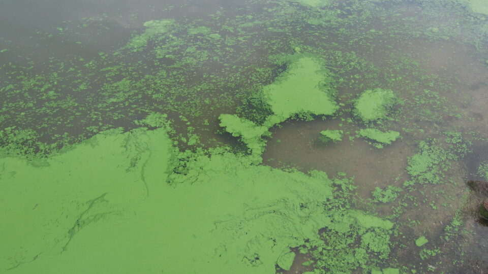
Harmful algal blooms – HABs – occur when colonies of algae grow out of control and produce toxic or harmful effects on people, marine life, and birds.  HABs occur naturally but their frequency and intensity are often associated with increased nutrient loading (mainly phosphorous and nitrogen) in bodies of water that is the result of runoff from sources like lawncare and agriculture.

Researchers at Florida Atlantic University have developed a technique for transforming cyanobacteria – also known as blue-green algae and a prime HAB material – into an effective material for removing phosphorous from water.

Their process converts blue-green algal biomass – essentially hazardous waste – into a custom-made adsorbent material that can pull harmful phosphorous from water.  The algae is first quickly heated up using microwaves and then it is modified by adding lanthanum chloride. 

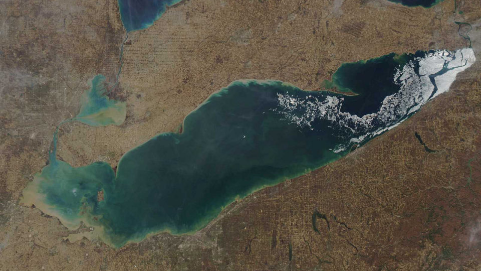
The study took blue-green algae from Florida’s Lake Okeechobee, synthesized the adsorbent material in minutes, and using only small amounts of it could remove 90% of the phosphorous present in only half an hour.  It worked perfectly well in the presence of natural organic matter.  Using the harmful algae itself to prevent algal growth in bodies of water is an innovative way to reduce its further occurrence.

Phosphorous is a major contributor to the occurrence of harmful algal blooms, which can lead to toxic water conditions, loss of aquatic life, and significant economic losses for the fishing and tourism industries.  This technique could prove to be an essential tool for managing the growing problem of nutrient pollution.

**********

Web Links

FAU Engineering Develops New Weapon Against Harmful Algal Blooms

Photo, posted October 27, 2010, courtesy of Jennifer L. Graham / U.S. Geological Survey via Flickr.

Earth Wise is a production of WAMC Northeast Public Radio

Palm oil and water quality

June 3, 2024 By EarthWise Leave a Comment

Palm oil is the world’s cheapest and most widely used vegetable oil.  In fact, more than 86 million tons of palm oil was consumed last year alone.  Even though few of us cook with it, palm oil can be found in approximately half of all packaged grocery items – everything from ice creams and pizzas to detergents and cosmetics. 

This massive global demand for palm oil is driving tropical deforestation around the world.  While many studies have shown how converting rainforests to oil palm plantations causes biodiversity loss, researchers from UMass Amherst are the first to demonstrate how these plantations also cause wide-ranging disturbances to nearby watersheds.

In the study, which was recently published in the journal Science of the Total Environment, the research team focused on the Kais River watershed of West Papua, a province in the far east of Indonesia.  Approximately 25% of the watershed has been turned into oil palm plantations. The watershed is also one of the oldest continually inhabited homes for different groups of Indigenous Papuans.

The researchers found that the conversion of tropical rainforest to oil palm plantation has increased precipitation, runoff, and soil moisture. Water quality in the watershed has also gotten dramatically worse: sedimentation has increased by 16.9%, nitrogen by 78.1%, and phosphorus by 144%.

The research team hopes regulators will work to limit the use of pesticides, conduct continuous water quality monitoring, and ensure that downstream communities have access to water quality information. 

**********

Web Links

Oil Palm Plantations Are Driving Massive Downstream Impact to Watershed

Photo, posted December 13, 2008, courtesy of Fitri Agung via Flickr.

Earth Wise is a production of WAMC Northeast Public Radio

Adirondack lakes becoming inhospitable for trout

February 15, 2024 By EarthWise Leave a Comment

Trout and other fish struggling in New York's Adirondack lakes

A combination of the warming climate and the phenomenon of lake browning are making the bottom of most lakes in New York’s Adirondack Mountains unlivable for cold water fish – such as trout, salmon, and whitefish – in the summer.

Lake browning occurs when dissolved organic matter from forests turns the water tea-brown.  Browning is the legacy of a century of acid rain and subsequently the fact that forest soils have suffered reduced capacity to absorb weak organic acids, leading to more dissolved plant matter flowing into lakes.  Climate change has increased the frequency of extreme precipitation events and the length of growing seasons, leading to more runoff of organic matter.

Browner water traps more of the sun’s heat at the top of the lake and blocks the sun’s rays from reaching deeper.  The result of the browning is lakes that are either too warm or too deoxygenated to support trout populations.

A study of 1,467 Adirondack lakes by Cornell University researchers found that only about 5% of them may continue to maintain water that is cold and oxygenated enough to support cold-water fish.

Deeper lakes fare much better because they have so much water that their oxygen is hard to deplete, but only 1% of all Adirondack lakes are deeper than 30 meters.  Another 4% are very clear because the influx of cold water outpaces the expansion of low-oxygen zones and limits the effects of browning.

The study urges the protection of as many lakes as possible from species invasions, nutrient and salt pollution, and other forms of environmental degradation. 

**********

Web Links

Most Adirondack lakes will likely become unsuitable for trout

Photo, posted July 17, 2011, courtesy of Lida via Flickr.

Earth Wise is a production of WAMC Northeast Public Radio

Lithium In The Salton Sea | Earth Wise

October 2, 2023 By EarthWise Leave a Comment

The Salton Sea is a shallow, landlocked, extremely salty body of water in the southern end of California.  It was formed from an inflow of water from the Colorado River in 1905 in the aftermath of a collapse of a canal during spring floods.  At one time, it was a thriving tourist destination and site of real estate speculation.  It was also a crucial habitat for migratory birds and various aquatic species.

Over the past 20 years, the Salton Sea has become increasingly desiccated and polluted with agricultural runoff and waste.  Rising salinity and the shrinking water supply from the Colorado River has made it uninhabitable for many species.

Recently, the Salton Sea has attracted new attention because of untouched lithium deposits located beneath its shores.  The general area has acquired the moniker “Lithium Valley” and has become a place where major energy companies are exploring advanced mining techniques such as Direct Lithium Extraction (DLE).  This new technique enables lithium to be captured from brine deposits without resource-intensive open-pit mining or evaporation pond processes.

Lithium is crucial for making the batteries that power electric vehicles.  DLE mining has attracted large investments from billionaires like Warren Buffet, Bill Gates, and Jeff Bezos. 

Lithium mining has generated major controversies because of its potential to damage the environment.  Whether the new mining techniques can avoid these problems and tap into the potential resources near the Salton Sea remains to be seen.  According to experts, the aquifers near the Salton Sea hold enough lithium to supply close to 40% of the global demand.

*********

Web Links

As Companies Eye Massive Lithium Deposits in California’s Salton Sea, Locals Anticipate a Mixed Bag

Photo, posted October 28, 2021, courtesy of Christian Collins via Flickr.

Earth Wise is a production of WAMC Northeast Public Radio

Rain Gardens And Residential Pollution | Earth Wise

July 12, 2023 By EarthWise Leave a Comment

Rain gardens are a solution to residential pollution of waterways

Stormwater runoff has become the largest source of residential pollution for waterways.  As rainwater runs down roofs, over driveways and patios, and off other hard surfaces, it can pick up pollutants as it flows directly into streams, wetlands, lakes, and groundwater aquifers.  That water is typically routed directly through stormwater pipes and ditches with little filtering or treatment.  The main emphasis is on getting the water off of people‘s property as quickly and efficiently as possible to avoid flooding.

Many municipalities are dealing with the problem by installing rain gardens, which are a type of green infrastructure in commercial spaces that slow down and treat water before it enters streams, wetlands, and other bodies of waters.  When designed and installed properly with appropriate plants, rain gardens are like miniature water treatment facilities   Water gathers in the rain garden, soaks into the soil, and is taken up by plants.  The plants filter nutrients, sediments, and toxic materials from the runoff before excess water ever gets to waterways.

Homeowners are being encouraged to build their own rain gardens.  They need to familiarize themselves with how runoff from their roof, driveway, sidewalk, and roads is currently being routed and treated.  The idea is to try to incorporate that runoff into a rain garden design with sufficient area and infiltration rates.  The runoff would ultimately flow out from a safe, designated location into storm drains at a slower rate than from the previous impervious surfaces.  Homeowners would need to work with their local jurisdictions to find out the requirements for re-routing water in their area and make sure any modifications prevent erosion and protect nearby homes, roads, and other infrastructure.

**********

Web Links

Rain gardens help keep pollutants out of waterways

Photo, posted March 3, 2017, courtesy of Jeremy Jeziorski / Oregon Convention Center via Flickr.

Earth Wise is a production of WAMC Northeast Public Radio

Great Salt Lake In Danger | Earth Wise

March 20, 2023 By EarthWise Leave a Comment

Great Salt Lake is threatened by the changing climate

Utah’s Great Salt Lake has been plagued by excessive water use and extensive drought conditions.  As of January, the lake dropped to record-low water levels, losing 73% of its water and exposing 60% of its lakebed. According to scientists, the lake could disappear entirely within five years.

Great Salt Lake is what is known as a “terminal lake,” which means that it is fed only by rain, snow, and runoff and has no rivers that take water to the ocean.  As a result, salt and minerals build up over time.  With so much salt in the water, only brine flies and shrimp can survive in it.  The unique ecosystem supports 10 million migratory birds.  As the lake continues to dry up, the water is becoming too salty for even algae and microbes to survive.  With shallow mud replacing previous shallow water, the nests of the 80,000 white pelicans that annually come to the lake are endangered by predators that can simply walk over to the eggs.

The historic low water levels have exposed 800 square miles of lakebed.  This lakebed holds centuries of natural and manmade toxins like mercury, arsenic, and selenium.  The exposed mud ultimately turns to dust that is carried off into the air.  This is contributing to what is already some of the worst winter air pollution in the nation.  Scientists warn that the unfolding ecological disaster may become a human health disaster.

State officials and university researchers have formed a “Great Salt Lake Strike Team” looking for ways to get more water to the lake.  There are a number of so-called moonshot proposals to save the lake.  It remains to be seen what will be done, but the clock is ticking.

**********

Web Links

Great Salt Lake will disappear in 5 years without massive ‘emergency rescue,’ scientists say

Scientists fear a Great Toxic Dustbowl could soon emerge from the Great Salt Lake

Photo, posted September 19, 2009, courtesy of John Morgan via Flickr.

Earth Wise is a production of WAMC Northeast Public Radio

Glacial Loss In The Swiss Alps | Earth Wise

December 14, 2022 By EarthWise Leave a Comment

Record glacial loss in the Swiss Alps

In 2022, glaciers in the Swiss Alps melted more than in any year on record.   This is the latest piece of bad news for the country’s glaciers, which have lost more than half of their volume of ice since the 1930s.

The melting season for Switzerland’s snow and ice typically starts in May and ends in early October.  This year’s melting season caused glaciers in the Diablerets mountain group to thin by an average of 13 feet, which is 3 times the amount of thinning observed over the past decade.   The Tsanfleuron pass between two of the glaciers is now exposed as bare rock for the first time in several thousand years. Across Switzerland, glaciers lost about 6% of their remaining volume just this year.  The previous worst year for glaciers was 2003, when losses were nearly 4%. 

There was significant melting this year in part because of the small amount of snowfall over the winter.  That snow melted quickly, being sped up by the warming effect of dust from the Sahara Desert falling on the snow.  By early summer, there was no longer a protective blanket of snow on the glaciers, exposing them to summer heat.

The loss of glaciers is far more serious than the disappearance of aesthetically pleasing landscape features.   Glaciers act as reservoirs of water that persist through the summer months.  Melt from glaciers provides water to ecosystems and creates habitats for plants and animals.  Cold runoff from glaciers affects downstream water temperatures which have a major impact on insects, fish, and other creatures.  Globally, melting glaciers contribute more than 20% of the observed ongoing sea-level rise.

**********

Web Links

Rocky Road for Swiss Glaciers

Photo, posted June 22, 2015, courtesy of Dennis Jarvis via Flickr.

Earth Wise is a production of WAMC Northeast Public Radio

Florida’s Starving Manatees | Earth Wise

January 12, 2022 By EarthWise Leave a Comment

Manatees, also called “sea cows”, have been the victims of farm runoff.  They have starved to death by the hundreds along Florida’s east coast because algae blooms fed by nitrogen-rich fertilizer runoff are proliferating on the ocean surface and blocking sunlight from reaching seagrass below.  Seagrass is the primary source of food for manatees in the winter.  As seagrass dies off, so do the manatees.

Over 1,000 manatees have been found dead so far this year.  It is estimated that fewer than 8,000 remain in Florida waters.  Efforts are underway to restore coastal seagrass in the region as well as clams and oysters, which filter pollutants from water.  Unless the water is cleared up, it will be difficult to regrow the seagrass.  But the current situation is that manatees are so short on food that they are eating seagrass roots, killing the plants and thwarting efforts to help seagrass recovery.

Given this dire situation, the federal governmental has approved a program of feeding manatees.  The starving animals will be fed by hand in Florida, which is a rare wildlife intervention.  Conservation agencies tend to favor leaving wild animals to their own foraging and hunting so that they don’t become dependent on human handouts.

During the trial phase of the program, wildlife experts are likely to feed the animals romaine lettuce and cabbage, which is what manatees in captivity eat.  The hope is to give the animals enough additional food for them to get through the winter.  The trial feeding will begin on private property.  It remains illegal for the public to feed manatees.

**********

Web Links

Florida to feed starving manatees in rare conservation move

Photo, posted February 21, 2008, courtesy of Keith Ramos/USFWS via Flickr.

Earth Wise is a production of WAMC Northeast Public Radio.

Offsetting Reef Acidification | Earth Wise

August 13, 2021 By EarthWise Leave a Comment

Could artificial ocean alkalinization help offset reef acidification?

The Great Barrier Reef is the world’s largest coral reef system.  It is composed of nearly 3,000 individual reefs and 900 islands covering an area of more than 130,000 square miles.  In recent times, it has been under unprecedented stress from ocean warming, tropical cyclones, sediment and nutrient runoff, marine pests, and ocean acidification.

Among these stressors, ocean acidification is one of the most significant threats to the long-term viability of the reef because acidification affects the ability of corals to rebuild and repair their structures and recover from bleaching events.

New research from CSIRO, Australia’s national science agency, studied the impact of artificial ocean alkalinization on the acidity of the waters in the Great Barrier Reef.  The idea is to inject a source of alkalinity into the ocean, an accelerated version of a natural process that occurs from the chemical weathering of minerals under the sea.

The results of the study, published in the journal Environmental Research Letters, are that injecting an alkalinizing agent into the ocean along the length of the Reef would make it possible to offset ten years’ worth of ocean acidification based on the present rate of human-generated carbon emissions.  Such an effort could use an abundant mineral resource like olivine, which is already mined near the Great Barrier Reef.  Releasing 30,000 tons a day of the alkalinizing agent from an existing shipping line from a bulk carrier would reach almost the whole of the Great Barrier Reef.

In response to the declining health of coral reef ecosystems, many different intervention concepts and technologies are under consideration.  The goal of these would be to minimize environmental pressures and enhance the resilience of the ecosystems.

**********

Web Links

Projected acidification of the Great Barrier Reef could be offset by ten years

Photo, posted August 4, 2019, courtesy of Larry Koester via Flickr.

Earth Wise is a production of WAMC Northeast Public Radio.

Greenland Becoming Darker | Earth Wise

July 5, 2021 By EarthWise Leave a Comment

Greenland is becoming darker and warmer

According to research published by Dartmouth University, a weather pattern that pushes snowfall away from parts of Greenland’s ice sheet is causing the continent to become darker and warmer.

Reducing the amount of fresh, lighter-colored snow exposes older, darker snow on the surface of Greenland’s ice sheets.  Fresh snow is the brightest and whitest. The reflectivity of snow decreases fairly quickly as it ages. This decrease in albedo – or reflectivity – allows the ice sheet to absorb more heat and therefore melt more quickly. 

The research attributes the decrease in snowfall in Greenland to a phenomenon called atmospheric blocking in which persistent high-pressure systems hover over the ice sheet for up to weeks at a time.  Such systems have increased over Greenland since the mid-1990s.  They push snowstorms to the north, hold warmer air over Western Greenland, and reduce light-blocking cloud cover.

All of this contributes to Greenland melting faster and faster.  According to research cited in the study, the Greenland ice sheet has warmed by nearly 5 degrees Fahrenheit since 1982.  Overall, Greenland is experiencing the greatest melt and runoff rates in the last 450 years, at the minimum, and quite likely the greatest rates in the last 7,000 years.

The Greenland ice sheet is the second largest ice body in the world, after the Antarctic ice sheet.  It is 1,800 miles long and about 700 miles wide at its greatest width.  Its thickness is between 1.2 and 1.9 miles.  If the entire sheet were to melt, it would lead to a global sea level rise of 24 feet.  So, the darkening of Greenland is a source of great concern.

**********

Web Links

Greenland Becoming Darker, Warmer as Snow Changes

Photo, posted April 3, 2012, courtesy of Francesco Paroni Sterbini via Flickr.

Earth Wise is a production of WAMC Northeast Public Radio.

The Corn Belt Is Losing Topsoil | Earth Wise

April 16, 2021 By EarthWise 2 Comments

Erosion is claiming the corn belt's topsoil

According to a new study published in the Proceedings of the National Academy of Sciences, more than a third of the farmland in the U.S. Corn Belt has completely lost its carbon-rich topsoil due to erosion.   The affected area is nearly 100 million acres and the amount of carbon loss is nearly 2 million tons.

The study, led by scientists at the University of Massachusetts, Amherst, found that the greatest loss of carbon-rich topsoil was on hilltops and ridgelines.  This indicates that tillage – the repeated plowing of fields – was the primary cause of the erosion because loosened soils move downslope.

The loss of topsoil has reduced corn and soybean yields in the Midwest by 6%, resulting in a loss of nearly $3 billion a year for farmers.  In addition, the loosening of the topsoil increases runoff of sediment and nutrients into nearly waterways, worsening water quality.

Previous studies have shown that no-till farming practices can have a significant impact on reducing erosion.  A study published last November found that if farmers shifted entirely to no-till practices, it would reduce soil erosion from U.S. agricultural fields by more than 70%, as well as significantly reducing nutrient and sediment runoff. 

No-till farming is the practice of planting crops without tilling the soil.  Instead, seeds are planted through the remains of previous crops by planters or drills that cut seed furrows, place the seeds, and close the furrow.  Currently less than 15% of farmland in the upper Mississippi River watershed is farmed with no-till practices. 

Even partial changes in tilling practices could produce positive results for topsoil retention and for waterways.

**********

Web Links

One-Third of Farmland in the U.S. Corn Belt Has Lost Its Topsoil

Photo, posted September 15, 2010, courtesy of the United Soybean Board / Soybean Checkoff via Flickr.

Earth Wise is a production of WAMC Northeast Public Radio.

What’s Been Killing Salmon? | Earth Wise

January 5, 2021 By EarthWise Leave a Comment

the mysterious deaths of Coho salmon

For decades, there have been mysterious deaths of Coho salmon.  The salmon return from the Pacific Ocean each year to spawn along the West Coast.   They can be found from Alaska all the way down into California.  After heavy rain events each fall, fish have been turning up dead in huge numbers before they spawn.  Normally, less than 1% of adult Coho die before spawning. In these mass death events, anywhere from 40% to 90% of fish can perish in affected streams.  The mysterious phenomenon has been the subject of intense research for years.

Recently, scientists announced that they may have solved the mystery.  There is a chemical antioxidant known as 6PPD that is used in the manufacture of tires around the world to make them last longer.  As tire treads break down over time, they leave behind bits of microplastics on roads.  The 6PPD in the plastic bits reacts with ozone to become another chemical:  a previously unreported substance called 6PPD-quinone.

That chemical turns out to be toxic to Coho salmon.  Researchers have found the presence of 6PPD-quinone in roadway water runoff samples taken from across the West Coast.  Based on these observations, they believe it is likely that exposure to this chemical is the main cause of the Coho salmon population decline.

Coho salmon are a favorite of sport fishermen and have great cultural significance to many Native American tribes on the West Coast.  The central California Coho population is classified as endangered and three other Coho populations are listed as threatened.

Tire industry representatives call the study results “preliminary” but say the industry is deeply committed to protecting the environment.  A safe chemical substitute for 6PPD is clearly needed.

**********

Web Links

Salmon have been dying mysteriously on the West Coast for years. Scientists think a chemical in tires may be responsible

Photo, posted November 17, 2011, courtesy of Lynn Ketchum/Oregon State University via Flickr.

Earth Wise is a production of WAMC Northeast Public Radio.

Road Salt Pollution

January 8, 2020 By EarthWise 1 Comment

Road salt pollution mirror lake

Mirror Lake is a popular recreational lake located in the Village of Lake Placid.  It is the most developed lake within the Adirondack Park, which is a publicly protected area that is actually larger than Yellowstone, Yosemite, Glacier, and Grand Canyon National Parks combined.

New research has revealed that road salt runoff into Mirror Lake is preventing natural water turnover which poses a risk to the balance of its ecology.  The study, which was published in Lake and Reservoir Management, found that road salt runoff is preventing spring mixing of the water column.    This creates more anoxic water conditions, meaning there is less oxygen in the water, and limits the ability of the habitat to support the native lake trout. 

Mirror Lake is the first lake in the Adirondack Park to show an interruption in lake turnover due to road salt.  Many lakes in northern climes experience so-called “dimictic turnover”, which is a natural process where wind and less stratified water conditions of spring and fall allow mixing of the water column that redistribute oxygen and nutrients throughout the lake.  High levels of surface-water chloride introduced into the lake from road salt runoff inhibit the mixing of the water column.

The lack of mixing and oxygenation is bad news for fish species such as lake trout, which require cold, oxygenated water to survive.  It may also put the lake at a greater risk of algal blooms.

Mirror Lake is small, surrounded by concentrated development, and receives the direct discharge of stormwater.  So, it is particularly vulnerable to road salt contamination.  Other lakes elsewhere in New York may experience similar conditions.  The researchers are confident that natural turnover conditions could be restored to the lake if road salt application in the watershed is reduced.

**********

Web Links

Road salt pollutes lake in one of the largest US protected areas, new study shows

Photo, posted January 5, 2018, courtesy of MTA of the State of NY via Flickr.

Earth Wise is a production of WAMC Northeast Public Radio.

Lake George Health Report

December 26, 2019 By EarthWise Leave a Comment

The Offshore Chemistry Program, run by the Darrin Fresh Water Institute at RPI, has been monitoring the deep waters of Lake George in New York for 40 years.  Lake George, nicknamed the Queen of American Lakes, is famed for the transparency of its water and a new report on the health of the lake reveals that it is doing rather well.

According to the report, although concentrations of chemicals and pollutants like salt and nutrients have increased in the deep waters of Lake George, they are still too low to harm the ecosystem at those depths.

The Offshore Chemistry Program studies the lake as part of a collaboration between RPI, IBM Research, and the FUND for Lake George that is called the Jefferson Project.  This long-term commitment provides a wealth of information over time matched by few lake studies in the world.

The recent results show that levels of salt, the nutrient orthophosphate, and chlorophyll have increased substantially over time, but none are yet at a level that will cause harm.

Orthophosphate occurs naturally, but most likely the higher levels are due to improperly functioning septic systems, failing wastewater treatment systems, and stormwater runoff.  The orthophosphate most likely triggered the increase in chlorophyll, which probably is associated with increased density of chlorophyll in individual algal cells, rather than an increase in total algal mass in the lake.

Overall, the results demonstrate the continuing resilience of Lake George to a growing array of stressors.  In nearly 40 years of human activities, the lake has changed in a number of ways, but the changes have so far been relatively small.  With such careful monitoring, we can hope to keep them that way.

**********

Web Links

Four Decades of Data Sounds Early Warning on Lake George

Photo, posted September 24, 2009, courtesy of GPA Photo Archive via Flickr.

Earth Wise is a production of WAMC Northeast Public Radio.

Renewable Natural Gas

September 30, 2019 By EarthWise Leave a Comment

Small-scale biogas systems have collected methane from landfills, sewage plants, and farms for decades.  Here in the US, biogas is finally catching up with modern techniques with the advent of third-party operators introducing more sophisticated technology to capture methane and pump it directly into pipelines.

Renewable methane or natural gas represents a significant mostly unexploited source of energy.  Examples include the vast amounts methane generated by manure from some of the 2,300 hog farms in eastern North Carolina, biodigesters that can turn clusters of large California dairy farms into energy hubs, as well as diverting food waste from landfills and transforming it into vehicle and heating fuels.

According to a 2014 EPA study, the U.S. could support at least 13,000 biogas facilities, fed by manure, landfill gas, and biosolids from sewage treatment plants.  Those facilities could produce over 650 billion cubic feet of biogas per year – enough renewable energy to power 3 million homes.

A study by the World Resources Institute estimated that the 50 million tons of organic waste sent to landfills or incinerated every year in the U.S. has the energy content of 6 billion gallons of diesel fuel, amounting to 15% of all diesel consumed by heavy-duty trucks and buses.

Utilizing all that biogas could help lower greenhouse gas emissions from some of the most difficult sectors to decarbonize – transportation, industry, and heating buildings.  In addition, ramped up renewable gas could keep organic waste out of landfills and prevent manure runoff into rivers and water supplies.

Renewable natural gas could be the next big thing in green energy.

**********

Web Links

Could Renewable Natural Gas Be the Next Big Thing in Green Energy?

Photo, posted June 19, 2013, courtesy of Alan Levine via Flickr.

Earth Wise is a production of WAMC Northeast Public Radio.

Drugs In The Water

April 15, 2019 By EarthWise Leave a Comment

According to a new study published in the journal Environmental Research Letters, concentrations of pharmaceuticals in rivers and lakes have dramatically increased across the globe over the past 20 years.

Traces of medicines get passed into waterways through the excretion of active drugs in human waste, the disposal of unused medicines down drains, and runoff from livestock farms.

The study looked in detail at two specific drugs:   carbamazepine, an anti-epileptic drug, and ciprofloxacin, an antibiotic.   The study found that the risk of ecological damage from the residue from these two drugs was 10 to 20 times higher in 2015 than in 1995.

Chronic exposure to carbamazepine, for example, has been shown to alter feeding behavior and reduce egg viability in zebrafish, as well as reduce reproductive success in crustaceans.  Antibiotics can alter major nutrient cycles and decrease the effectiveness of bacteria-based wastewater treatment systems.

The study, led by researchers from the Netherlands, created a new model estimating concentrations of the two drugs over a 20-year period in 449 aquatic systems around the globe.  The model predicts a relatively high environmental risk in densely populated and dry areas such as the Middle East. 

When the researchers compared the model’s results to samples from four river systems in various locations, they found that the actual drug concentrations were even higher than model results, in some cases by a factor of 10 to 100. 

The new model should act as a guide for a more thorough investigation into pharmaceutical residues in waterways, which pose significant environmental risks all over the world.

**********

Web Links

Concentrations of Pharmaceuticals in Freshwater Increasingly Globally

Photo, posted March 22, 2012, courtesy of Rajeev Rajagopalan via Flickr.

Earth Wise is a production of WAMC Northeast Public Radio.

Protection From Toxic Algae

March 28, 2019 By EarthWise Leave a Comment

Toxic algal blooms have been a growing problem in recent years associated with warming waters and nutrient-rich agricultural runoff in lakes, rivers, and oceans.  In 2014, an algal bloom in Lake Erie left half a million residents of Toledo, Ohio without safe drinking water for three days.

The most common toxic substance released by algal blooms in the lake is called microcystin, which is closely linked to liver cancer and other diseases.  Toxicologists measure microcystin and other contaminants using the metric of parts per billion.  The EPA recommends that young children not drink water containing more than 0.3 parts per billion and adults no more than 1.6 parts per billion of microcystin.

Scientists at the University of Toledo have been working on developing a biofilter that uses naturally occurring Lake Erie bacteria to remove microcystin released by algal blooms and thereby reduce or eliminate the use of chlorine and other chemicals.

They have successfully isolated a number of types of bacteria that degrade microcystin toxin at a daily rate of up to 19 parts per billion.  To their knowledge, such bacteria have not been previously used to fight algal blooms in other parts of the world.  Based on the recorded toxin levels in Lake Erie in recent years, the bacteria would be able to effectively remove microcystin from water supplies.  None of the 13 bacterial isolates they found have any association with human disease so their use in future water-purifying biofilters should not pose a public health concern.

The researchers are now developing and testing biofilters, which are water filters containing the specialized bacteria that will degrade the toxins from lake water as it flows through the filter.

**********

Web Links

Scientists advance new technology to protect drinking water from Lake Erie algal toxins

Photo, posted April 30, 2014, courtesy of NOAA via Flickr.

Earth Wise is a production of WAMC Northeast Public Radio.

Clean Water In The Corn Belt

October 26, 2018 By EarthWise Leave a Comment

https://earthwiseradio.org/wp-content/uploads/2018/10/EW-10-26-18-Clean-Water-in-the-Corn-Belt.mp3

Iowa is grappling with a growing battle over the integrity of its water.  Nitrogen and phosphates have been flowing in ever-increasing quantities into Iowa’s public water supplies and dealing with the problem has become a major political issue in the state.

[Read more…] about Clean Water In The Corn Belt

Small Grains In Corn Country

January 31, 2018 By EarthWise Leave a Comment

https://earthwiseradio.org/wp-content/uploads/2017/12/EW-01-31-18-Small-Grains-in-Corn-Country.mp3

Large portions of the Midwest are called the Corn Belt and for good reason.  Overall, about 90 million acres or 140,000 square miles of the United States are planted with corn and about half of that is in Iowa, Illinois, Nebraska and Minnesota.  In most of the Corn Belt, the corn is planted in rotation with soybeans.  Both are warm weather crops and the soil is left barren for nearly half of the year when the two crops are out of season.

[Read more…] about Small Grains In Corn Country

Pine Barrens Threatened

September 29, 2017 By EarthWise Leave a Comment

https://earthwiseradio.org/wp-content/uploads/2017/08/EW-09-29-17-Pine-Barrens-Threatened.mp3

Pine barrens occur throughout the northeastern U.S. from New Jersey to Maine.  They are plant communities that occur on dry, acidic, infertile soils dominated by grasses, forbs, low shrubs, and small to medium-sized pines.  The Pine Bush Preserve in Albany, New York is one of the larger inland pine barrens in the country.

[Read more…] about Pine Barrens Threatened

  • Page 1
  • Page 2
  • Go to Next Page »

Primary Sidebar

Recent Episodes

  • An uninsurable future
  • Clean energy and jobs
  • Insect declines in remote regions
  • Fossil fuel producing nations ignoring climate goals
  • Trouble for clownfishes

WAMC Northeast Public Radio

WAMC/Northeast Public Radio is a regional public radio network serving parts of seven northeastern states (more...)

Copyright © 2026 ·