• Skip to primary navigation
  • Skip to main content
  • Skip to primary sidebar

Earth Wise

A look at our changing environment.

  • Home
  • About Earth Wise
  • Where to Listen
  • All Articles
  • Show Search
Hide Search
You are here: Home / Archives for wetlands

wetlands

Restored wetlands and climate

September 23, 2025 By EarthWise Leave a Comment

Restoring wetlands offers massive climate benefit within one year

Forests are well-known to be major storehouses of carbon in the environment.  Less known but also extremely important are peatlands and wetlands and, like forests, both have suffered declines as a result of human activity.  And, like forests, both are seeing efforts at restoration.

Restoring peatlands has the drawback that it initially causes a spike in methane emissions, and it therefore takes a long time for them to have a net positive effect on the climate after they are restored. 

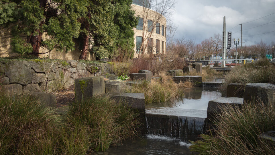
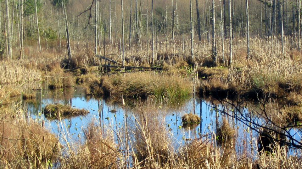
In a new study by RMIT University in Australia, it was found that reviving floodplain wetlands reduces carbon emissions by 39% and restores critical ecosystem functions in one year without any increase in methane emissions.  The 6-year study reintroduced water flow to a degraded freshwater wetland.  Over the course of the study, carbon stocks in the wetland increased by 53%.  Freshwater wetlands cover less than 10% of the Earth’s surface but contribute up to 25% of global methane emissions.  Despite this, they still play a crucial role in global ecosystem function.

Floodplain or riparian wetlands comprise over half of global wetlands.   They store less carbon than peatlands but restoring them gains substantial ecosystem benefits quickly.  The carbon is stored in plant roots and soil.  Wetlands are nature’s purification system removing both nitrogen from waterways and carbon from the atmosphere. 

Restoring and managing freshwater wetlands for the purpose of carbon sequestration also boosts flood and drought resilience.  Riparian wetlands are connected to other ecosystems like rivers and streams and provide benefits to them.

**********

Web Links

Restored wetlands reap benefits for climate, drought-resilience after just one year: study

Photo, posted January 7, 2014, courtesy of Tom Barnes / USFWS via Flickr.

Earth Wise is a production of WAMC Northeast Public Radio

Disappearing wetlands

August 21, 2025 By EarthWise Leave a Comment

More than 170 countries gathered recently to discuss how to save wetlands, which are critical ecosystems.  However, the U.S. was a no-show for most of the summit and Russia said it will withdraw from the wetlands treaty.

Wetlands are a crucial element of all life on Earth, supplying fresh water, oxygen, habitat, and food.  The Ramsar Convention, an international treaty focused on the conservation and wise use of wetlands, is the oldest modern global environmental agreement, adopted in 1971. 

Despite this agreement, since 1970 more than 35% of wetlands have been lost or degraded.  A recent report compiled by more than 60 experts from around the world issued a dire warning that the decline of wetlands spells trouble for global food security, climate stability, and even the capacity for life on Earth to persist.

Sadly, geopolitics have overtaken even the instinct for survival.  Because of a prior resolution to monitor Ukranian wetlands harmed during Russia’s ongoing war there, Russia now intends to withdraw from the treaty.  Meanwhile, the U.S. delegate to the wetlands summit only showed up near the end of the meeting to demand that conference documents make no mention of climate change, diversity equity and inclusion, gender, UN sustainable development goals, or zero growth.

Disengagement by the United States from the world’s increasing and shared environmental problems is a global crisis that only worsens existing global crises.

**********

Web Links

Earth’s Wetlands Are Disappearing and Global Efforts to Save Them Are Unraveling

Photo, posted October 8, 2013, courtesy of Marek Kusmin via Flickr.

Earth Wise is a production of WAMC Northeast Public Radio

New Orleans is sinking

August 14, 2025 By EarthWise Leave a Comment

As climate change accelerates, rising sea levels are putting coastal communities at greater risk of flooding and storm surge. Driven by melting glaciers and warming oceans, global sea levels are rising at an increasing rate. For low-lying cities like New Orleans, even small increases can have serious consequences. And that risk is compounded by another factor: the land itself is sinking.

Much of New Orleans already sits at or below sea level, and parts of the city and its surrounding wetlands are gradually sinking. While most of the city remains stable, a new study by researchers from Tulane University suggests that sections of the region’s $15 billion post-Katrina flood protection system may require ongoing upgrades to keep pace with long-term subsidence.

The study, recently published in the journal Science Advances, used satellite data to track changes in ground elevation across Greater New Orleans between 2002-2020.  The researchers found that some areas – including neighborhoods, wetlands, and even concrete floodwalls – are sinking by more than an inch each year. In some spots, the land is dropping by nearly two inches annually.

Alarmingly, some of the concrete floodwalls and levees built to protect the city after Hurricane Katrina are themselves sinking. In a few cases, they are losing elevation faster than sea levels are rising, reducing their capacity to block storm surges.

The study highlights how satellite monitoring can play a critical role in guiding infrastructure maintenance and urban planning – not just in New Orleans – but in vulnerable coastal cities around the world.

**********

Web Links

Vertical land motion in Greater New Orleans: Insights into underlying drivers and impact to flood protection infrastructure

Photo, posted September 22, 2010, courtesy of U.S. Army Corps of Engineers via Flickr.

Earth Wise is a production of WAMC Northeast Public Radio

Nature: An important climate ally

June 10, 2025 By EarthWise Leave a Comment

Nature is often seen as a victim of climate change, but it’s also one of the most powerful tools we have to fight it. Natural ecosystems, such as forests, wetlands, grasslands, oceans, and soils, absorb and store massive amounts of carbon dioxide. These ecosystems not only help reduce the concentration of greenhouse gases in the atmosphere, but they also regulate temperatures and provide buffers against extreme weather.

One of the most effective strategies for mitigating climate change is simply protecting and restoring these natural areas. For example, mangrove forests – those coastal wetlands filled with tangled, salt-tolerant trees – sequester carbon at high rates and help protect coastal communities from storm surges and rising seas.  Peatlands – another type of wetland – store more carbon than all the world’s forests combined – despite only covering 3% of Earth’s land surface.  Global restoration efforts are underway, from replanting mangroves in Southeast Asia to rewetting degraded peatlands in Europe.

Creating urban green spaces like parks and community gardens, restoring forests through native tree plantings, and adopting sustainable agricultural practices like cover cropping and agroforestry are all proven to be low-cost, high-impact climate solutions. 

While nature-based solutions are gaining recognition, they remain critically underfunded, according to a recent United Nations report.  Closing this gap is essential to unlocking nature’s  full climate potential.

Investing in nature isn’t just about preserving Earth’s natural beauty.  It’s a practical strategy for building a more resilient and sustainable future.

**********

Web Links

Mangrove forests and rising seas

Financing Nature-based Solutions for a better future

Finding peatlands

The Importance Of Urban Green Spaces

Photo, posted October 23, 2011, courtesy of the Everglades National Park / NPS via Flickr.

Earth Wise is a production of WAMC Northeast Public Radio

Finding peatlands

May 15, 2025 By EarthWise Leave a Comment

Peatlands are a special kind of wetland that have enormous potential for helping to mitigate climate change.  They are great at capturing carbon because their constantly soggy soils deprive decomposer organisms of the oxygen they need to break down dead plants.  Living plants absorb carbon dioxide from the atmosphere and incorporate the carbon into their tissues.  When plants die, decomposers like bacteria digest the plant matter and release the carbon dioxide back into the atmosphere.

Researchers from the University of California Santa Cruz found that the average per-area carbon densities in peatlands in Colombia are four to ten times higher than those in the Amazon rainforest.  This agrees with other studies around the world.  On a global scale, peatlands cover only 3% of land areas but store more carbon than all the world’s trees.  Peatlands are unsung heroes helping to reduce the impact of fossil fuel emissions.

Peatlands can only store carbon if they remain constantly wet.  When they are drained for agriculture or other development, decomposer organisms get back to work digesting organic matter and releasing carbon dioxide back into the atmosphere.

A major challenge in protecting peatland is finding them.  They are often hard to distinguish from other types of wetlands. 

The Santa Cruz researchers have been identifying and locating peatlands in Colombia, where decades of civil war had made many parts of the country inaccessible for research.  Finding and protecting peatlands there and in many other places around the world is an important task in the battle against climate change.

**********

Web Links

Colombia’s peatlands could be a crucial tool to fight climate change. But first we have to find them.

Photo, posted January 2, 2018, courtesy of Roni Ziade / U.S. Forest Service via Flickr.

Earth Wise is a production of WAMC Northeast Public Radio

Warming estuaries

September 13, 2024 By EarthWise Leave a Comment

Estuaries in South Florida are rapidly warming

Estuaries and their surrounding wetlands are bodies of water where freshwater from rivers and streams mixes with salt water from the ocean to create brackish water.  These brackish ecosystems support many unique plant and animal communities around the world. 

But ocean water temperature around the world continues to warm.  In fact, from 1901 to 2023, the average sea surface temperature has increased by 0.14°F per decade, and 2023 was the warmest year on record.

While sea surface temperatures are on the rise, the problem is more pronounced in South Florida’s estuaries.  According to a new study by researchers from the University of South Florida College of Marine Science and the National Park Service, estuaries have experienced rapid warming over the past two decades. 

In fact, the research team found that sea surface temperature in four estuaries in South Florida – Florida Bay, Tampa Bay, St. Lucie Estuary and Caloosahatchee River Estuary- has risen around 70% faster than the Gulf of Mexico, and 500% faster than the global oceans. 

Their findings, which were recently published in the journals Environmental Research Letters and Estuaries and Coasts, paint a troubling picture for the marine life that calls South Florida’s estuaries home.

The research team has speculated about the possible causes of the rapid rate of warming, including evaporation, water capacity, and residence time, but no single factor has been revealed as dominant. 

The researchers hope to partner with colleagues at the Florida Fish and Wildlife Conservation Commission and NOAA to explore the potential impacts of water temperatures on seagrass and coral populations in South Florida.

**********

Web Links

Estuaries in South Florida are warming faster than the Gulf of Mexico and global ocean

What is an estuary?

Photo, posted August 18, 2016, courtesy of City of St. Pete via Flickr.

Earth Wise is a production of WAMC Northeast Public Radio

How to make cities cooler

March 26, 2024 By EarthWise Leave a Comment

Green spaces and waterways help keep cities cool

In cities, the air, surface, and soil temperatures are almost always warmer than in rural areas. This is known as the urban heat island effect.  Urban heat islands occur when cities replace natural land cover with dense concentrations of pavement, buildings, and other surfaces that absorb and retain heat.

Urban planners around the world have been researching ways to reduce the effects of heat in cities.  For example, trees, green roofs, and vegetation can help reduce urban heat island effects by shading building surfaces, deflecting radiation from the sun, and releasing moisture into the atmosphere.

A new study led by researchers from the University of Surrey in the U.K. has analyzed how well various green spaces and waterways are able to cool down cities.  The study, which was recently published in the journal The Innovation, found that wetlands, parks, and even botanical gardens are among the best ways to keep cities cool.   

In fact, the researchers found that botanical gardens can cool city air by a whopping 9°F during heatwaves on average.  Wetlands can cool city air by 8.5°F on average, followed by rain gardens at 8.1°F, green walls at 7.4°F, street trees at 6.8°F, city farms at 6.3°F, city parks at 5.8°F, and reservoirs and playgrounds at 5.2°F. 

The researchers also found that cities can unlock even greater benefits by connecting green spaces into green corridors.  Greening projects can also help remove carbon emissions and prevent flooding.

The research team hopes its findings will help urban planners design more resilient cities. 

**********

Web Links

Wetlands, parks and even botanical gardens among the best ways to cool cities during heatwaves

Photo, posted April 25, 2022, courtesy of Catherine Poh Huay Tan via Flickr.

Earth Wise is a production of WAMC Northeast Public Radio

Greenland is greening

March 21, 2024 By EarthWise Leave a Comment

Greenland is greening

Despite their names, Iceland is very green, and Greenland is very icy.  But in Greenland, that is changing.  Temperatures in the world’s largest island are rising twice as fast as they are in the rest of the world and, as a result, the icy rocky landscape is turning increasingly green.

Satellite records reveal that over the last three decades Greenland has lost 11,000 square miles of ice, which is an area about the size of Massachusetts.  As the ice melts off, tundra and shrublands takes its place.  The ice melt moves sediment and silt and eventually wetlands and fenlands are formed.

Between the late 1980s and the late 2010s, the areas of Greenland covered by vegetation have more than doubled.  The new green areas cover roughly 33,000 square miles, which is an area the size of Maine.

Greenland’s dramatic changes are the result of the warming climate, but in turn, those changes are accelerating climate change.  Land covered with dark green vegetation absorbs more energy from the sun thereby warming the air whereas ice-covered landscapes reflect much of the sun’s energy back into space.  In addition, the rapidly expanding wetlands are a significant source of methane, which traps even more heat in the atmosphere.

Greenland is a poster child for the effects of climate change.  Its glaciers and icecaps are shrinking, glacier-fed lakes are expanding, permafrost lakes are draining, and rivers are transporting vast amounts of sediment and widening.  All of this is going on as its vegetation cover and species diversity is expanding.

**********

Web Links

In Icy Greenland, Area Covered by Vegetation Has More Than Doubled in Size

Photo, posted September 20, 2019, courtesy of Amanda via Flickr.

Earth Wise is a production of WAMC Northeast Public Radio

Rain Gardens And Residential Pollution | Earth Wise

July 12, 2023 By EarthWise Leave a Comment

Rain gardens are a solution to residential pollution of waterways

Stormwater runoff has become the largest source of residential pollution for waterways.  As rainwater runs down roofs, over driveways and patios, and off other hard surfaces, it can pick up pollutants as it flows directly into streams, wetlands, lakes, and groundwater aquifers.  That water is typically routed directly through stormwater pipes and ditches with little filtering or treatment.  The main emphasis is on getting the water off of people‘s property as quickly and efficiently as possible to avoid flooding.

Many municipalities are dealing with the problem by installing rain gardens, which are a type of green infrastructure in commercial spaces that slow down and treat water before it enters streams, wetlands, and other bodies of waters.  When designed and installed properly with appropriate plants, rain gardens are like miniature water treatment facilities   Water gathers in the rain garden, soaks into the soil, and is taken up by plants.  The plants filter nutrients, sediments, and toxic materials from the runoff before excess water ever gets to waterways.

Homeowners are being encouraged to build their own rain gardens.  They need to familiarize themselves with how runoff from their roof, driveway, sidewalk, and roads is currently being routed and treated.  The idea is to try to incorporate that runoff into a rain garden design with sufficient area and infiltration rates.  The runoff would ultimately flow out from a safe, designated location into storm drains at a slower rate than from the previous impervious surfaces.  Homeowners would need to work with their local jurisdictions to find out the requirements for re-routing water in their area and make sure any modifications prevent erosion and protect nearby homes, roads, and other infrastructure.

**********

Web Links

Rain gardens help keep pollutants out of waterways

Photo, posted March 3, 2017, courtesy of Jeremy Jeziorski / Oregon Convention Center via Flickr.

Earth Wise is a production of WAMC Northeast Public Radio

Coastal Land Reclamation | Earth Wise

April 3, 2023 By EarthWise Leave a Comment

People are artificially expanding the coastlines of cities by extending industrial ports and creating luxury residential waterfronts.  Major cities have added 900 square miles to their coastlines just since 2000. 

A recent study published in the journal Earth’s Future made use of satellite imagery to analyze land changes in 135 cities with populations of at least 1 million.  But population growth is not the only driver of coastal land reclamation.  It is popular in places that are eager to enhance their reputation and promote revenue growth.

At present, coastal land reclamation is most common in the Global South, where many economies are growing. In the past, the Global North dominated the use of coastal land construction.

The largest additions to land area occurred in China, Indonesia, and the United Arab Emirates.  Port extension is the most common reason for development.  Shanghai alone has added 135 square miles of land.

New land is typically created by piling sediments in the ocean, building cement sea walls and structures to contain sediments or cement, or sometimes filling in wetlands and other shallow areas of water near the coast.  The ecological impacts of reclamation are immense and, unfortunately, are not always considered.  Projects affect both the local ecosystems as well as those of the places where fill materials are obtained.

Industrialization and the need for urban space have driven much coastal reclamation.  Some projects, such as the palm-tree-shaped artificial islands of Dubai, are essentially for prestige.  Some cities, including Shanghai, are building new land in consideration of future sea level rise.

**********

Web Links

New Land Creation on Waterfronts Increasing, Study Finds

Photo, posted October 15, 2010, courtesy of Werner Bayer via Flickr.

Earth Wise is a production of WAMC Northeast Public Radio

Protecting Wetlands | Earth Wise

March 28, 2023 By EarthWise Leave a Comment

Wetlands are distinct ecosystems that are flooded or saturated by water, either permanently or seasonally.  They include mangroves, marshes, swamps, forested wetlands, bogs, wet prairies, and vernal pools.   The feature that most wetlands share is soil or substrate that is at least periodically saturated with or covered by water.

Wetlands are some of the most threatened ecosystems in the world.  While wetlands can be affected by a variety of natural stressors, including erosion, droughts, and storms, human activities have been the major driver of wetland decline. 

But according to a new study by researchers from McGill University in Canada, the global loss of wetland areas since 1700 has likely been overestimated.  The research team calculated that the area of wetland ecosystems around the world has declined 21-35% since 1700 as a result of human activities – far less than the 50-87% decline estimated in other studies.  The study’s focus beyond regions with historically high wetland losses and its avoidance of possibly misleading extrapolations likely resulted in the lower estimate.      

According to the study, which was published in the journal Nature, more than 2.1 million square miles of wetlands have been lost during the past 300 years – an area roughly the size of India.  The five countries with the highest wetland losses are the United States, China, India, Russia and Indonesia. 

But discovering that fewer wetlands have been historically lost than previously thought gives researchers a second chance to protect wetlands.  The findings of the study will help researchers prioritize global conservation and restoration actions.

**********

Web Links

A second chance to protect wetlands

Photo, posted February 2, 2005, courtesy of Jan Tik via Flickr.

Earth Wise is a production of WAMC Northeast Public Radio

Agriculture Turning Wild Plants Into Weeds | Earth Wise

February 7, 2023 By EarthWise Leave a Comment

Modern agriculture practices are turning wild plants into weeds

We often hear about the importance of native plants in the environment and how invasive species can wreak havoc with ecosystems.   But it turns out that human activities can change the characteristics of native species and create unexpected new problems.

Common waterhemp is plant native to North America that typically grows near lakes and streams.  It never used to be any kind of problem, but in recent times it has become nearly impossible to eradicate from farms as a result of genetic adaptations triggered by modern agriculture.

A study led by researchers at the University of British Columbia looked at waterhemp samples from modern farms and neighboring wetlands and compared them with historical samples dating back as far as 1820 stored in various museums.

In recent times, mutations in genes related to drought tolerance, rapid growth, and resistance to herbicides have resulted in waterhemp that has become a pervasive weed on farms.  These genetic shifts, scarcely ever seen in historical samples, have made the plant thrive among human agricultural activities and enable it to outcompete crops.

Genetic analysis of the plants showed that herbicide-resistant mutations that were mostly absent from historical samples stand out as factors that allow waterhemp to prosper in agricultural settings. There are some plants in natural habitats that have herbicide-resistant mutations, but in many cases, these mutations are actually harmful to the plants in the wild.

Understanding how plant adaptations occur on relatively short timescales is increasingly important as farming and climate  change continue to drive rapid plant evolution.

**********

Web Links

How intensive agriculture turned a wild plant into a pervasive weed

Photo, posted February 16, 2016, courtesy of Aqua Mechanical via Flickr.

Earth Wise is a production of WAMC Northeast Public Radio

Lithium Mining And Andes Ecosystems | Earth Wise

October 28, 2022 By EarthWise Leave a Comment

The global demand for lithium could be an ecological disaster

A remote region in the high Andes straddling the borders between Argentina, Bolivia, and Chile has become known as the Lithium Triangle.   The area has become the focus of a global rush for lithium to make batteries for electric cars.  The global demand for lithium is expected to quadruple by 2030 to 2.6 million tons a year.

According to the U.S. Geological Survey, more than half of the world’s lithium reserves are dissolved in ancient underground water within the Lithium Triangle.  The cheapest way to extract the lithium is to pump the underground water to the surface and evaporate it in the sun to concentrate the lithium carbonate contained in it.

Every ton of lithium carbonate extracted using this cheap, low-tech method dissipates into the air about half a million gallons of water that is vital to the arid high Andes.  The process lowers water tables and has the potential to dry up lakes, wetlands, springs, and rivers.  Hydrologists and conservationists say the lithium rush in Argentina is likely to turn the region’s delicate ecosystems to deserts.

The global drive for green vehicles to fight climate change has the potential to be an ecological disaster in this remote region of South America and for the indigenous people who live there.

The environmental impacts are not an inevitable price for the transition to electric vehicles.  First of all, there are alternatives to lithium.  Both zinc and nickel are potential substitutes in rechargeable batteries.  But, there are also ways of obtaining lithium that are less destructive than evaporating the metal from saline ecosystems.  It is up to battery manufacturers, automakers, and financiers to start demanding lithium from sources that are less environmentally destructive.

**********

Web Links

Why the Rush to Mine Lithium Could Dry Up the High Andes

Photo, posted September 25, 2015, courtesy of Nuno Luciano via Flickr.

Earth Wise is a production of WAMC Northeast Public Radio

Reshaping Our Planet | Earth Wise

July 12, 2022 By EarthWise Leave a Comment

Human activity is changing the planet

Human activity – especially agriculture – has altered 70% of the land on our planet.  According to a new report from the United Nations, damage to the Earth’s lands has put the planet on “crisis footing”.

Our health, our economy, and our well-being depend on land.  The food we eat, the water we drink, and the air we breathe all rely on status of the land to at least some extent.

According to the report, up to 40% of the planet’s land is already degraded, affecting half of the people alive today.  At current rates, an additional area nearly the size of South America will be degraded by 2050.

Degradation of land occurs in various ways, including deforestation, desertification, and the loss of wetlands or grasslands.  All of these things are caused by human activities.  As forests, savannas, wetlands, and mangrove swamps are converted to agriculture or are lost to urban expansion, greenhouse gas emissions rapidly increase, adding to the effects of climate change.  The climate crisis, biodiversity loss, and land degradation are integrally linked.

Much of the blame for degraded landscapes is on humanity’s ever-expanding need for food and the modern farming systems that produce it.  The global food system is responsible for 80% of the world’s deforestation, 70% of freshwater use, and is the greatest driver of land-based biodiversity loss.  Modern agriculture has altered the face of the planet more than any other human activity.

The report urges efforts at restoration of land.  Restoration can take multiple forms, including planting forests and shrubs or grazing livestock and growing crops between trees instead of clearing existing forests.

**********

Web Links

UN Report Says Humanity Has Altered 70 Percent of the Earth’s Land, Putting the Planet on a ‘Crisis Footing’

Photo, posted June 20, 2010, courtesy of Nicholas A. Tonelli via Flickr.

Earth Wise is a production of WAMC Northeast Public Radio.

The Atmosphere Is Thirstier | Earth Wise      

May 9, 2022 By EarthWise Leave a Comment

The American West is in the throes of a two-decade-long drought.  The climate there is getting warmer and drier, which has led to increasing demand for water resources from both humans and ecosystems.  According to a new study by the Desert Research Institute and collaborators, the atmosphere across much of the U.S. is also demanding a greater share of water than it used to.

Evaporative demand, which is also called atmospheric thirst, is a measure of the potential loss of water from the earth’s surface up to the atmosphere.  It is a function of temperature, humidity, wind speed, and solar radiation.  The study, published in the Journal of Hydrometeorology, assessed trends in evaporative demand during a 40-year period from 1980-2020.

The study’s findings showed substantial increases in atmospheric thirst across much of the Western U.S. over that period, with the largest increases centered around the Rio Grande and Lower Colorado rivers.  This is important because atmospheric thirst is a persistent force in pushing Western landscapes and water supplies toward drought.

The study found that, on average, increases in temperature were responsible for 57% of the changes observed in atmospheric thirst, humidity 26%, and the other factors playing lesser roles.

For farmers and other water users, increases in atmospheric thirst mean that, in the future, more water will be required to meet existing water needs.  Crops already require more water than they did in the past and can be expected to require more water in the future.  Over time, for every drop of precipitation that falls, less and less water is likely to drain into streams, wetlands, aquifers, or other water bodies.

**********

Web Links

New study shows robust increases in atmospheric thirst across much of U.S. during past 40 years

Photo, posted August 9, 2007, courtesy of William Clifford via Flickr.

Earth Wise is a production of WAMC Northeast Public Radio.

Snakes Near A Plane | Earth Wise

September 15, 2021 By EarthWise Leave a Comment

San Francisco International Airport is the seventh-busiest airport in the United States.  In a typical year, approximately 55 million people pass through SFO on their way to destinations throughout North America and beyond.

At some point during their journey to or from the terminals at SFO, each one of those people will pass by a seemingly unremarkable 180-acre parcel of land.  Surrounded by highways and train tracks, the soggy and overgrown vacant lot isn’t just home to rows of power lines.  It’s also home to the world’s largest population of the beautiful and highly endangered San Francisco garter snake.   

According to a recent study conducted by the U.S. Geological Survey, there are approximately 1,300 San Francisco garter snakes at SFO’s West of Bayshore property – the greatest concentration of these snakes ever recorded.

Conservationists have long known that the San Francisco garter snake was in trouble.  In fact, it landed on the U.S. Fish and Wildlife Service’s very first endangered species list, which was published in 1967.  Over the years, agricultural, commercial, and urban development have destroyed much of its wetland habitat, as well as much of its primary food source, the California red-legged frog.  The snakes have also been a popular target for poachers and collectors.

Since 2008, SFO has been working with the USFWS on a recovery strategy for the species.  Together, they’ve made enhancements to the West of Bayshore habitat, including building rainfed ponds and deepening existing wetlands.  They have also added fences to protect habitat and prevent illegal collection.

But low population counts at other locations means the recovery for the San Francisco garter snake is far from over. 

************

Web Links

Combining genetic and demographic monitoring better informs conservation of an endangered urban snake

A San Francisco Airport Site Is Crawling With Snakes—And That’s a Good Thing

Photo, posted April 16, 2011, courtesy of Brian Gratwicke via Flickr.

Earth Wise is a production of WAMC Northeast Public Radio.

Global Warming Could Stabilize | Earth Wise

February 19, 2021 By EarthWise Leave a Comment

Reducing emissions could stabilize global temperatures

The world has been heading toward climate disaster with the effects of greenhouse gas-induced warming looming larger and larger.  But recent analysis published in Nature Climate Change offers hope that rapidly eliminating emissions could stabilize global temperatures just within a couple of decades.

For quite some time, it has been assumed that further global warming would be locked in for generations regardless of the extent of emissions reductions going forward.  This conclusion was based on having a certain carbon dioxide concentration in the atmosphere which would linger for hundreds of years even if emissions were reduced.

Recent analysis takes into account the dynamism of the Earth’s natural systems which could actually reduce atmospheric CO2 content because of the huge carbon absorption capacity of oceans, wetlands, and forests.  The key requirement is to drastically reduce emissions so that these natural systems can take over.

More than 100 countries have pledged to get to net zero emissions by 2050.  That means they will emit no more carbon dioxide than is removed from the atmosphere by such actions as restoring forests.   The UK, Japan, and the European Union are among the countries that have set this zero target, and the United States is joining the club.

Climate models show that a global temperature rise of 2 degrees Celsius over that of the pre-industrial period would lead to global calamities that include punishing heatwaves, flooding, and mass displacement of people.  The world has already heated up by 1.1 degrees and governments have committed to restrain the rise to less than 1.5 degrees under the Paris Climate Agreement.

**********

Web Links

Global Warming Could Stabilize Faster than Originally Thought If Nations Achieve Net Zero

Photo, posted September 10, 2017, courtesy of Ron Cogswell via Flickr.

Earth Wise is a production of WAMC Northeast Public Radio.

Land Use Change And Flooding | Earth Wise

September 30, 2020 By EarthWise Leave a Comment

Land use change leads to increased flooding

Land use change refers to the conversion of a piece of land’s use by humans from one purpose to another. Land use change is commonly associated with biodiversity loss and increased greenhouse gas emissions.  But how does land use change impact water cycles? 

According to researchers from the University of Göttingen in Germany, IPB University, and BMKG (both in Indonesia), the expansion of monocultures, such as rubber and oil palm plantations, leads to more frequent and more severe flooding.  The researchers explain the increase in flooding “with a complex interplay of ecohydrological and social processes, including soil degradation in monocultures, the expansion of oil palm plantations into wetlands, and the construction of flood protection dams.” 

For the study, which was recently published in the journal Ecology & Society, the research team interviewed nearly 100 Indonesian farmers, villagers, and decision-makers in Sumatra.  The team supplemented its research with data on precipitation, river and groundwater levels, soil properties, and regional mapping. 

During large-scale land use change – like plantation expansions – newly-compacted soil causes rainwater to runoff as opposed to being absorbed.  As more plantations are established in floodplains, the owners try to control flooding on their land by building barriers.  But these dams often lead to increased flooding on neighboring lands.  This understandably triggers social tensions between other farmers and plantation owners.     

In order to reduce the negative impact of land use change on the water cycle, the research team suggests soil protection and improved planning – especially in floodplains – would be a good place to start.  

**********

Web Links

Land use change leads to increased flooding in Indonesia

Photo, posted October 8, 2018, courtesy of Artem Beliaikin via Flickr.

Earth Wise is a production of WAMC Northeast Public Radio.

Natural Habitats And Strawberry Farms | Earth Wise

April 22, 2020 By EarthWise Leave a Comment

natural habitat benefits farms

According to a new study led by researchers from the University of California – Davis, conserving natural habitat around strawberry fields can protect farmers’ yields, their bottom line, and the environment.  The study also suggests that conserving natural habitat in this way has no detectable threat to food safety. 

In this study, which was recently published in the journal Ecological Applications, the research team conducted surveys and experiments at 20 strawberry farms along California’s Central Coast.  This region is responsible for 43% of the nation’s strawberry production. 

The researchers found that strawberry farmers were better off with natural habitat, like forests, grasslands, wetlands, and shrubs, around their farms than without it.  According to the study’s models, adding natural habitat can reduce crop damage costs by 23%.  Removing natural habitat can increase costs by as much as 76%. 

Importantly, the strawberry farms with natural habitat surrounding them showed no signs of increased fecal contamination.  While bird feces were regularly encountered on the ground, only 2 of 10,000 strawberries examined show signs of direct fecal contamination.  Those contaminated berries would be discarded during the hand-harvesting process.   

These findings run contradictory to current best practice recommendations that support natural habitat removal around strawberry farms in order to decrease bird fecal contamination and crop damage.  These food safety requirements were a consequence of the deadly outbreak of E. coli in 2006, which was traced back to spinach grown in this region.   

It seems like our agricultural landscapes can both support and benefit from biodiversity. 

**********

Web Links

Natural habitat around farms a win for strawberry growers, birds and consumers

Photo, posted June 16, 2011, courtesy of the USDA via Flickr.

Earth Wise is a production of WAMC Northeast Public Radio.

The Rising Threat Of Rising Seas | Earth Wise

February 3, 2020 By EarthWise Leave a Comment

global sea level rising

Global sea level rose by about 6 inches during the 20th century.  It is currently rising more than twice as fast and accelerating.  The rate of rise was 2.5 times faster from 2006 to 2016 than it was for nearly all of the 20th century.

Sea level rise occurs when glaciers and ice sheets lose mass.  Much of that meltwater comes from Greenland and Antarctica.  But levels also rise because, as water warms, it expands.  Added to that are the effects of human activities such as groundwater depletion and a geological phenomenon called isostatic adjustment that is going on in parts of the East Coast where the land is actually sinking.

In Atlantic Canada, sea level rise is outpacing the global average and has already led to boardwalks swamped by swelling tides, drowned forests, submerged wharfs, and threatened historic shoreline buildings.

Recent research suggests that globally, land now occupied by 300 million people could be affected by floods at least once a year by 2050 unless carbon emissions are significantly reduced, and coastal defenses strengthened.  (This new figure is more than three times higher than earlier estimates).

Researchers at Dalhousie University in Nova Scotia are studying nature-based strategies for mitigating the effects of the rising seas.  These include conserving or restoring coastal ecosystems like dunes, wetlands, and reefs which could provide protection at a lower cost than building seawalls and other man-made obstacles.  Wetlands, for example, can reduce the force of waves and act as obstacles to storm surges, while also trapping sediment and stemming erosion.  Wetlands also serve as important carbon stores, but it is estimated that roughly half of the world’s coastal wetlands have been lost over the past 100 years to human activity and extreme weather events.

**********

Web Links

The Looming Threat of Rising Sea Levels – And What We Can Do About it

Photo, posted February 14, 2015, courtesy of Flickr.

Earth Wise is a production of WAMC Northeast Public Radio.

  • Page 1
  • Page 2
  • Go to Next Page »

Primary Sidebar

Recent Episodes

  • An uninsurable future
  • Clean energy and jobs
  • Insect declines in remote regions
  • Fossil fuel producing nations ignoring climate goals
  • Trouble for clownfishes

WAMC Northeast Public Radio

WAMC/Northeast Public Radio is a regional public radio network serving parts of seven northeastern states (more...)

Copyright © 2025 ·