• Skip to primary navigation
  • Skip to main content
  • Skip to primary sidebar

Earth Wise

A look at our changing environment.

  • Home
  • About Earth Wise
  • Where to Listen
  • All Articles
  • Show Search
Hide Search
You are here: Home / Archives for unprecedented

unprecedented

Record forest loss

July 3, 2025 By EarthWise Leave a Comment

A record amount of forest was lost last year

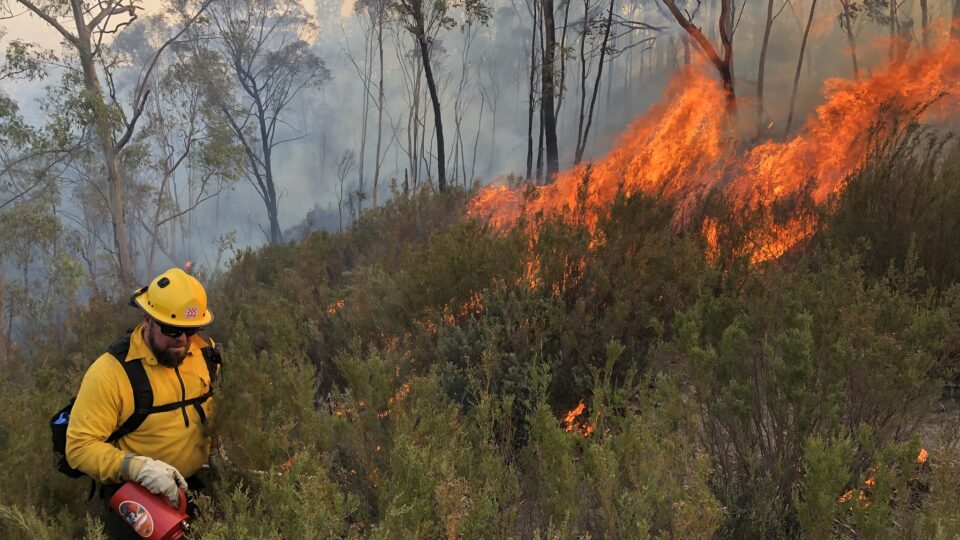
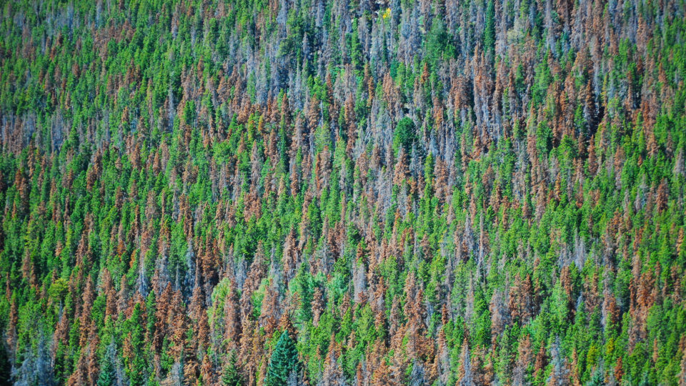
The world lost a record amount of forests last year.  The biggest factor for the unprecedented losses were wildfires that raged around the world.

According to the annual update by the University of Maryland and the World Resources Institute, pristine rainforests alone lost 17 million acres, which was nearly twice as much as in the previous year.  Overall, the world lost the equivalent of 18 soccer fields of forested land every minute last year.

Over time, agriculture has been the primary cause of forest losses, but last year, for the first time since record-keeping began, fires were the leading cause, accounting for nearly half of all the destruction.

With respect to the climate, wildfires emitted over 4 billion tons of greenhouse gasses, which is more than four times the amount generated by air travel in 2023.

Land clearing for agriculture, cattle farming, and other purposes was by no means in decline last year.  In fact, it rose by 14%, which was the sharpest increase in almost a decade.  This trend could permanently transform critical natural areas, unleashing large amounts of carbon, intensifying climate change, and fueling even more extreme fires.

Forests are a major contributor to the natural storing of carbon dioxide.  Intact tropical forests are especially effective at storing carbon.

Brazil has the largest area of tropical forest and it accounted for 42% of all tropical primary forest loss in 2024.  Fires fueled by the worst drought on record caused two thirds of that loss, more than a sixfold increase over the previous year.

**********

Web Links

Global Forest Loss Hit a Record Last Year as Fires Raged

Photo, posted September 12, 2024, courtesy of the USDA Forest Service via Flickr.

Earth Wise is a production of WAMC Northeast Public Radio

The human impact on biodiversity

April 28, 2025 By EarthWise Leave a Comment

Humans have a devastating impact on biodiversity

Biodiversity is under threat.  More and more plant and animal species are disappearing and humans are to blame.  Humans cause biodiversity loss through habitat destruction, invasive species, pollution, direct exploitation, and climate change, all of which are significantly influenced by human activities.

But until now, drawing broad conclusions about human impacts on biodiversity has been difficult because a clear, global overview of how human activity affects nature across all species did not exist. Most studies have focused on specific places, impacts, or time periods.

To fill these research gaps, a research team from the University of Zurich in Switzerland and the Swiss Federal Institute of Aquatic Science and Technology conducted an unprecedented synthesis study.  The researchers compiled data from around 2,100 studies that compared biodiversity at almost 50,000 sites affected by humans with similar places that hadn’t been affected by humans. 

The synthesis study, which was recently published in the journal Nature, found humans are having a highly detrimental impact on biodiversity worldwide.  In fact, not only is the number of species declining, but the composition of species communities is also changing.  On average, the number of species at impacted sites was almost 20% lower than at unaffected sites.

The study, which is one of the largest ever conducted on this topic, highlights the widespread negative impact of human activities on nature, and emphasizes the need to consider all forms of life when assessing biodiversity loss. 

**********

Web Links

The Devastating Human Impact on Biodiversity

Photo, posted November 19, 2014, courtesy of Green Mountain Girls Farm via Flickr.

Earth Wise is a production of WAMC Northeast Public Radio

National drought

December 5, 2024 By EarthWise Leave a Comment

Climate change brings with it many kinds of extreme weather.  It isn’t just higher temperatures.  It is changing patterns of weather and weather events that are rare or even unprecedented.

Late October saw drought conditions throughout almost the entire United States.   Only Alaska and Kentucky did not have at least moderate drought conditions.

The previous four months were consistently warmer than normal over a large area of the country.  When that period started, about a quarter of the country was at least somewhat dry, but in late October, 87% of the country was dry.

Droughts in many parts of the U.S. and in places around the world are becoming more frequent, longer in duration, and more severe. 

Residents of New York City were urged to start conserving water.  This October was the driest October since record keeping began in 1869.  The upstate reservoirs that supply New York’s water were below two-thirds full.  They are normally more than three-quarters full in the fall.

Even the Southeast, which received huge amounts of rain from Hurricane Helene, is experiencing drought.  Not much rain had fallen since that storm and warmer temperatures mean more evaporation and drier soils.

Drought is not just a lack of precipitation.  Drought conditions are driven by abnormally high temperatures that remove moisture from the atmosphere and the ground.

Whether widespread drought conditions will persist is unknown.  If a predicted La Niña condition develops in the tropical Pacific, drought conditions in the southern half of the country could get worse, but the Northeast could see lots of rain and snow.

To have nearly the entire country experiencing drought conditions is pretty rare.  But unusual weather is becoming the new normal.

**********

Web Links

In a Record, All but Two U.S. States Are in Drought

Photo, posted May 21, 2024, courtesy of Adam Bartlett via Flickr.

Earth Wise is a production of WAMC Northeast Public Radio

2023: A year of extreme climate

September 11, 2024 By EarthWise 1 Comment

2023 was a year of climate extremes

There have already been all sorts of extreme weather this year in many parts of the world and undoubtedly there will be more to talk about in the coming months.  But the American Meteorological Society has recently published its State of the Climate report for 2023 and it was a year for the record books.

In 2023, the Earth’s layers of heat-reflecting clouds had the lowest extent ever measured.  That means that skies were clearer around the world than on average, a situation that amplifies the warming of the planet.  Since 1980, clouds have decreased by more than half a percent per decade. 

The most dramatic climate effect last year occurred in the world’s oceans.  About 94% of all ocean surfaces experienced a marine heatwave during the year.  The global average annual sea surface temperature anomaly was 0.13 degrees Celsius above the previous record set in 2016.  This is a huge variation for the ocean.  Ocean heatwave conditions stayed in place for at least 10 months in 2023 in vast reaches of the world’s oceans.  Ocean heat was so remarkable that climate scientists are now using the term “super-marine heatwaves” to describe what is going on. 

There were many other ways in which 2023 experienced weather extremes.  July experienced a record-high 7.9% of the world’s land areas in severe drought conditions.  During the year, most of the world experienced much warmer-than-average conditions, especially in the higher northern latitudes.  These unprecedented changes to the climate are unlikely to be one-time occurrences; 2024 is likely to be another one for the record books.  

**********

Web Links

New Federal Report Details More of 2023’s Extreme Climate Conditions

Photo, posted May 27, 2021, courtesy of Wendy Cover/NOAA via Flickr.

Earth Wise is a production of WAMC Northeast Public Radio

Wildfire Smoke And Global Weather | Earth Wise

June 1, 2023 By EarthWise Leave a Comment

In 2019 and 2020, wildfires burned 72,000 square miles in Australia, roughly the same area as the entire country of Syria. During the nine months when the fires raged, persistent and widespread plumes of smoke filled the atmosphere.

These aerosols brightened a vast area of clouds above the subtropical Pacific Ocean.  Beneath these clouds, the surface of the ocean and the atmosphere cooled.  The effect of this was an unexpected and long-lasting cool phase of the Pacific’s La Niña-El Niño cycle.

A new modeling study by the National Center for Atmospheric Research in Boulder, Colorado quantified the extent to which aerosols from the Australian wildfires made clouds over the tropical Pacific reflect more sunlight back towards space.  The resultant cooling shifted the cloud and rain belt known as the Intertropical Convergence Zone northward.  These effects may have helped trigger the unusual three-year-long La Niña, which lasted from late 2019 through 2022.

The impacts of that La Niña included intensifying drought and famine in Eastern Africa and priming the Atlantic Ocean for hurricanes.  2020 was the most active tropical storm season on record, with 31 storm systems, including 11 that made landfall in the U.S.

The study highlights widespread multi-year climate impacts caused by an unprecedented wildfire season.  The wildfires set off a chain of events that influenced weather far from where the fires occurred.  In the future, climate experts will need to include the potential effects of wildfires in their forecasts.

**********

Web Links

How Wildfire Smoke from Australia Affected Climate Events Around the World

Photo, posted December 19, 2019, courtesy of Simon Rumi via Flickr.

Earth Wise is a production of WAMC Northeast Public Radio

Ocean-based Climate Intervention And Deep-sea Ecosystems | Earth Wise

May 2, 2023 By EarthWise Leave a Comment

Climate interventions could jeopardize deep sea ecosystems

Deep-sea ecosystems cover more than 40% of the Earth.  These regions are some of the least well-known and understood areas of our planet but are home to numerous ecosystems.  The deep seas are already directly exposed to the effects of human-induced climate change but could potentially be greatly threatened by efforts to artificially counteract climate change.

A class of geoengineering solutions called ocean-based climate interventions are increasingly being claimed as promising ways to mitigate climate change.  Such interventions would remove carbon dioxide from the atmosphere and sequester it in the deep sea.  There is very little known about the impact of such efforts on ocean biogeochemistry and the biodiversity of ocean ecosystems.

One approach is direct CO2 injection into the deep ocean, which would sequester large amounts of it and reduce the concentration in the atmosphere.  However, too much carbon dioxide in the water is called hypercapnia, which can have serious consequences on marine life.

Other approaches include ocean fertilization – which is enhancing phytoplankton production at the surface, leading to their eventual deposition on the deep-sea floor – and crop waste deposition – which is deep-sea disposal of terrestrial crop waste. 

A multinational study led by the Scripps Institution of Oceanography warns that there needs to be much more research and governance before any such interventions ever take place.  The deep sea faces unprecedented threats from industrial fisheries, pollution, warming, deoxygenation, acidification, and other climate-related problems.  Ocean-based climate intervention represents yet another serious threat to the functioning of these essential ecosystems.

**********

Web Links

HKU Marine Scientist contributes to research assessing the potential risks of ocean-based climate intervention technologies on deep-sea ecosystems

Photo, posted January 6, 2010, courtesy of Emrys Roberts via Flickr.

Earth Wise is a production of WAMC Northeast Public Radio

Record European Heat | Earth Wise

February 13, 2023 By EarthWise Leave a Comment

The new year began with record-breaking heat across Europe.  In fact, on December 31 and January 1, about 5,000 all-time high temperature records for those dates were broken, in some cases by margins of more than 9 degrees Fahrenheit.

On New Year’s Day, eight European countries recorded their warmest January day ever. These were Liechtenstein, the Czech Republic, Poland, the Netherlands, Belarus, Lithuania, Denmark, and Latvia.

Many of the European cities affected by the heat wave would ordinarily be covered in snow at that time of year.  For example, Vaduz, the capital of Liechtenstein, the Czech town of Javornik, and the Polish village of Jodlownik, all recorded peak temperatures between 66 and 68 degrees Fahrenheit.

By the measure of how far above normal temperatures rose, it was the most extreme heat wave in European history.  Last summer saw record-breaking heat waves across much of Europe, but the actual temperature increases over normal were smaller than what just occurred at the beginning of the year.

The source of the exceptional heat was a warm mass of air from the west coast of Africa moving across Europe.  As is the case for any individual weather event, one cannot definitively attribute this one to climate change.  However, it is abundantly clear that because of climate change, extreme weather events of all types are becoming more frequent and more intense.

The unprecedented European weather does have the effect of helping to ease the energy crisis that has gripped the European continent.   The Russian invasion of Ukraine has led to soaring natural gas prices.  The warm weather has meant a lower demand for gas, causing gas prices to drop to their lowest level since the start of the war.

**********

Web Links

‘Uncharted territory’: January heat records smashed across Europe

Photo, posted August 13, 2019, courtesy of Herbert Frank via Flickr.

Earth Wise is a production of WAMC Northeast Public Radio

Efficiency Of Offshore Wind | Earth Wise

December 10, 2021 By EarthWise Leave a Comment

Exploring the efficiency of offshore wind turbines

After many years of debates, delays, and controversies, offshore wind is about to expand in a big way in the United States.  The White House has announced the goal to deploy 30 gigawatts of offshore wind – enough to power 90 million homes – along the East Coast seaboard by 2030.

In New York State, there are now five offshore wind projects in active development.  The state goal is to have nearly a gigawatt of offshore wind by 2035, enough to power over 4 million homes.

These projects involve the use of thousands of physically large, high-capacity wind turbines deployed over large areas at an unprecedented scale.  Such mammoth installations bring with them unique problems.

Low-turbulence conditions over water lead to the fact that individual wind farms will experience each other’s wake (the disturbance of their airflow) even when turbine arrays are 15 to 50 miles apart.  As a result, turbines may fatigue earlier, and groups of turbines may experience up to 30% lower power production due to wake effects.

Industry trends are causing an increased probability of large wake-induced energy losses within individual wind farms and an increasing probability of wake interactions.

These issues have been studied in new research published by researchers at Cornell University.  The research presents simulations that may be helpful to optimize turbine spacing in the ongoing deployments and assist plans for future ones.  Improved understanding of wind turbine and wind-farm wake is essential in ensuring that the financial investments in offshore wind result in electricity-generation goals met at the lowest possible cost.

According to Department of Energy studies, offshore wind resources around the United States could potentially generate more electricity than the entire country currently uses.

**********

Web Links

Scientists bring efficiency to expanding offshore wind energy

Photo, posted August 9, 2016, courtesy of Lars Plougmann via Flickr.

Earth Wise is a production of WAMC Northeast Public Radio.

Wildfires And Algal Blooms

October 12, 2021 By EarthWise Leave a Comment

Australia is no stranger to wildfires. But the 2019-2020 season proved to be particularly severe: wildfires destroyed 3,100 homes, displaced 65,000 people, and burned more than 72,000 square miles – roughly the same size as Washington State. The season is colloquially referred to as the Black Summer.

According to a new study recently published in the journal Nature, clouds of smoke and ash from these wildfires triggered widespread algal blooms thousands of miles downwind to the east in the Southern Ocean.

The study, which was led by researchers from Duke University, shows that aerosol particles in the smoke and ash fertilized the water as they fell into it.  This provided the nutrients that fueled unprecedented blooms in that region, conclusively linking for the first time a large-scale response in marine life to fertilization by pyrogenic iron aerosols from a wildfire.

This finding raises questions about the role wildfires may play in the growth of phytoplankton, the microscopic marine algae that – through photosynthesis – absorbs large amounts of climate-warming carbon dioxide from Earth’s atmosphere. 

According to the research team, the Australian algal blooms were so extensive that the subsequent increase in photosynthesis may have temporarily offset a substantial portion of the wildfires’ CO2 emissions.  It remains to be seen how much of the absorbed CO2 remains safely stored in the ocean and how much it has been released back into the atmosphere. 

The researchers plan to investigate the fate of the phytoplankton further.  They also plan more research to better predict where and when aerosol deposition will boost phytoplankton growth in the future.  

**********

Web Links

Australian wildfires triggered massive algal blooms in Southern Ocean

Photo, posted January 12, 2020, courtesy of BLM-Idaho via Flickr.

XXXXXXXXXXXXXXX

Drought And Desalination | Earth Wise

October 11, 2021 By EarthWise Leave a Comment

Improving water desalination to combat droughts

The Western US is currently experiencing what might be the worst drought in over 1,000 years.   The region has seen many droughts in the past, but the changing climate is making dry years drier and wet years wetter.   Diminishing snow-packs mean that rivers, streams, reservoirs, and soil are not replenished enough in the spring and summer.

Meanwhile, the Southwest has seen a growth rate over the past 60 years that is twice that of the rest of the country.  More and more people are moving to areas expected to get even drier in the years to come.  There have been unprecedented water allocation cuts from the Colorado River – which provides water to seven states – and there have been shutdowns of hydroelectric power plants.

Only three percent of the planet’s water is fresh water and much of that is not available for our use.  Over 120 countries have turned to desalination for at least some of their drinking water.  In the US, the largest plant is in Carlsbad, California and a huge new plant is likely to be built in Huntington Beach, California.

Desalination has its drawbacks.  It is expensive, consumes large amounts of energy, and has detrimental environmental impacts.  Most of the world’s desal plants now use membrane filtration technology but there are still many that use the thermal distillation method.

There are efforts around the world aimed at improving desalination.  A giant project in Saudi Arabia is based on solar heating of sea water.  The U.S. Army and the University of Rochester are working on a different solar-based system.  European companies are developing a floating seawater desalination plant powered by wind energy. 

Droughts seem to be here to stay.  Finding better ways to get fresh water is essential.

**********

Web Links

A 1,000 Year Drought is Hitting the West. Could Desalination Be a Solution?

Photo, posted May 31, 2021, courtesy of Frank Schulenburg via Flickr.

Earth Wise is a production of WAMC Northeast Public Radio.

A Record Low For Lake Mead | Earth Wise

October 4, 2021 By EarthWise Leave a Comment

The low water level of Lake Mead is causing regional water shortages

Lake Mead is the reservoir that was formed by the Hoover Dam on the Colorado River.  The lake spans the Arizona-Nevada border.  It is the largest reservoir in the United States in terms of water capacity.  The lake is part of a system that supplies water to at least 40 million people in seven states and in Northern Mexico.

As of August 22, this year, Lake Mead was filled to just 35% of its capacity.  This low water level is happening while 95% of the land in nine Western states is under some level of drought conditions and 64% of the land is under extreme drought conditions.  A so-called megadrought has been going on for 22 years and may be the worst dry spell in the region in twelve centuries.

As of the end of July, the water elevation at the Hoover Dam was 1,067 feet above sea level, the lowest it has been since April 1937 when the lake was still being filled after dam construction.  The level has dropped by 132 feet since July 2000.  At maximum capacity, Lake Mead reaches an elevation of 1,220 feet and holds 9.3 trillion gallons of water.

With Lake Mead at 35% of capacity, Lake Powell on the Colorado at 31%, and the entire Lower Colorado system at 40%, water allocations for the coming water year are being cut back. Mexico will see a 5% reduction, Nevada will be cut 7%, and Arizona will lose 18% of its apportionment.   This unprecedented official declaration of a water shortage demonstrates the severity of the drought and low reservoir conditions.

**********

Web Links

Lake Mead Drops to a Record Low

Photo, posted August 7, 2018, courtesy of Renee Grayson via Flickr.

Earth Wise is a production of WAMC Northeast Public Radio.

Record Heat Across the Globe | Earth Wise

August 4, 2021 By EarthWise Leave a Comment

Record high temperatures recorded across the globe

While the Pacific Northwest was setting new records for high temperatures in June, many other places across the globe also experienced unprecedented heat.  Places in Russia and Scandinavia, including locations above the Arctic Circle, set new records for temperature.

The heatwave in Europe was the result of a persistent northward bulge in the polar jet stream.  This blocking pattern in the jet stream has been prevalent over Scandinavia this year and has contributed to unusually warm conditions there.  Further east, similar conditions have created unusual warm temperatures in Siberia.

On June 23, Moscow reached a high of 94.6 degrees, the hottest June temperature on record.  Helsinki, Finland set a record at 89.1 degrees, and both Belarus at 96.3 degrees and Estonia at 94.3 degrees set new records.  The town of Saskylah, north of the Arctic Circle in Siberia, measured almost 90 degrees on June 20. 

High temperature records have been broken in many places.  The all-time record high for June for all of Mexico fell at Mexicali in Baja California on June 17 when the temperature reached 125 degrees.  Palm Springs, California, while known for its desert heat, nonetheless set a new all-time high temperature of 123 degrees and also set a new record for the warmest overnight low temperature for a June night anywhere in North America at an unbelievable 105 degrees.

Stories like this have become all-too common in recent years and are undoubtedly going to occur with greater frequency as the world’s climate continues to react to the growing buildup of greenhouse gases in the atmosphere.

**********

Web Links

A Scorcher in Siberia and Europe

Photo, posted June 8, 2007, courtesy of Niko Pettersen via Flickr.

Earth Wise is a production of WAMC Northeast Public Radio.

Shrinking Ice In The Bering Sea | Earth Wise

October 19, 2020 By EarthWise Leave a Comment

Bering Sea ice continues to shrink

The Bering Sea forms the divide between the two largest landmasses on Earth:  Eurasia and the Americas.  Recent analysis of vegetation from a Bering Sea island has determined that the extent of sea ice in the region is the lowest it has been for over 5,000 years.

St. Matthew Island, a small island in the middle of the Bering Sea, has essentially been recording what is happening in the ocean and atmosphere around it, in the form of the composition of peat layers on the island.  By analyzing the chemical composition of peat core samples, scientists can estimate how sea ice in the region has changed over the course of time.

Changes in the relative amounts of two oxygen isotopes in the sediment and plant debris trapped in the peat on the island reflect the nature of precipitation during the period when the peat layers formed.  That ratio is correlated with the amount of sea ice in the region.  Satellite data acquired over the past 40 years confirms this correlation.

Analysis of the data shows that the current ice levels are unprecedented in the last 5,500 years.  These long-term findings affirm that reductions in Bering Sea ice are due to more than recent higher temperatures associated with global warming.  Atmospheric and ocean currents, which have also been altered by climate change, play a large role in the presence of sea ice.

Summertime sea ice in the Arctic was expected to reach its second-lowest extent in September in 40 years of observation.  Sea ice typically builds up again each winter, but the changes in ice extents actually lag behind changes in greenhouse gas level by decades.  Future ice loss is already built into the system.

**********

Web Links

Bering Sea ice extent is at most reduced state in last 5,500 years

Photo, posted December 2, 2012, courtesy of Bering Land Bridge National Preserve via Flickr.

Earth Wise is a production of WAMC Northeast Public Radio.

Tsunami And Invasive Species

November 13, 2017 By EarthWise Leave a Comment

https://earthwiseradio.org/wp-content/uploads/2017/10/EW-11-13-17-Tsunami-and-Invasive-Species.mp3

According to a new study published in the journal Science, scientists have discovered that hundreds of Japanese marine species have been swept across the Pacific Ocean to the United States following the deadly Tsunami in 2011.        

[Read more…] about Tsunami And Invasive Species

The Spread Of Bark Beetles

November 9, 2017 By EarthWise Leave a Comment

https://earthwiseradio.org/wp-content/uploads/2017/10/EW-11-09-17-The-Spread-of-Bark-Beetles.mp3

Bark beetles are a global scourge of evergreen forests.  Mountain pine beetles have destroyed pine trees across western North America.  Spruce beetles decimated spruce trees from New Mexico into Colorado and beyond.  Altogether, bark beetles have ravaged 85,000 square miles of forest in the western U.S, an area the size of Utah, since 2000.  They have killed trees across an additional 65,000 square miles of British Columbian forests and have caused millions of dollars of damage to the lumber industry in states like Alabama and Mississippi.

[Read more…] about The Spread Of Bark Beetles

Primary Sidebar

Recent Episodes

  • An uninsurable future
  • Clean energy and jobs
  • Insect declines in remote regions
  • Fossil fuel producing nations ignoring climate goals
  • Trouble for clownfishes

WAMC Northeast Public Radio

WAMC/Northeast Public Radio is a regional public radio network serving parts of seven northeastern states (more...)

Copyright © 2025 ·