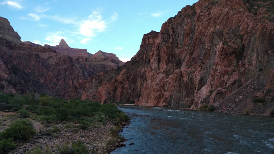
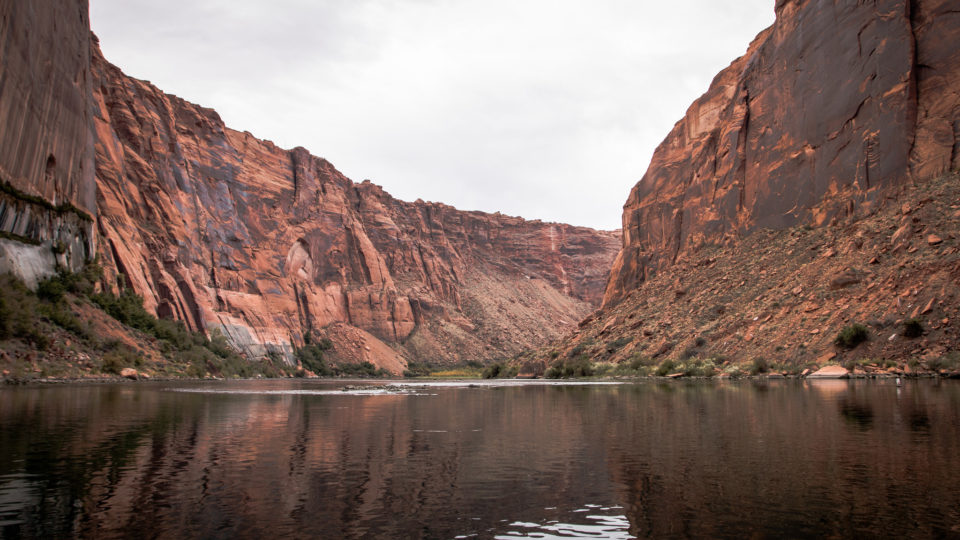
• Skip to primary navigation
  • Skip to main content
  • Skip to primary sidebar

Earth Wise

A look at our changing environment.

  • Home
  • About Earth Wise
  • Where to Listen
  • All Articles
  • Show Search
Hide Search
You are here: Home / Archives for water levels

water levels

A Groundwater Crisis | Earth Wise

September 22, 2023 By EarthWise Leave a Comment

A groundwater crisis is brewing

The majority of U.S. drinking water systems rely on groundwater, as do America’s farms.  Even though groundwater is a crucial resource for the country, there is no central oversight or even monitoring of its status across the country.  The health of the country’s aquifers is difficult to gauge.

The New York Times spent months amassing data from 80,000 wells across the country by reaching out to federal, state, and local agencies nationwide.

The survey found that 45% of the wells examined showed a statistically significant decline in water levels since 1980.  Forty percent of the sites reached record-low water levels over the past 10 years, with last year the worst yet.

Over pumping is the biggest problem.  State regulations tend to be weak and there is no federal oversight.  The warming climate reduces snowpack, which means less water in rivers, increasing the need to tap into groundwater.  Warmer weather means thirstier plants, increasing the demand for water.

It is a nationwide problem, not just one in the drought-ridden West.  Arkansas, which produces half of the country’s rice, is pumping groundwater twice as fast as nature can replace it.  Three-quarters of Maryland’s wells have seen substantial drops in water levels.

As groundwater is pumped out, the empty space can collapse under the weight of the rock and soil above it, permanently diminishing the capacity for future groundwater storage.

There are likely to be parts of the U.S. that run out of drinking water and groundwater depletion threatens America’s status as an agricultural superpower. Objectively, the status of American groundwater is a crisis that threatens the long-term survival of communities and industries that depend on it. 

**********

Web Links

Five Takeaways From Our Investigation Into America’s Groundwater Crisis

Photo, posted July 25, 2009, courtesy of Chris Happel via Flickr.

Earth Wise is a production of WAMC Northeast Public Radio

Lakes Are Shrinking | Earth Wise

September 11, 2023 By EarthWise Leave a Comment

A study by the University of Colorado Boulder has found that more than half of the world’s largest lakes have shrunk over the last three decades.  This is a very big problem because about one-quarter of the Earth’s population lives in the basin of a drying lake.  People depend on lakes for drinking water and irrigation and lakes are central to the survival of local ecosystems as well as migrating birds.  Lakes cover only about 3% of the planet, but they hold nearly 90% of the liquid surface freshwater.

The study used satellite observations from 1992 to 2020 to estimate the area and water levels of nearly 2,000 freshwater bodies.  These account for 96% of Earth’s total natural lake storage and 83% of that in man-made reservoirs.  About 53% of the world’s lakes have clearly shrunk, while only 22% have gained water.  The study estimates that about 160 trillion gallons of water has been lost over the 28-year period.  That’s about 17 times the maximum capacity of Lake Mead, the largest reservoir in the United States.

Many of the world’s most significant lakes have been shrinking. The dramatic declines in Lake Mead have been headline news for years.  The Caspian Sea, which is the world’s largest inland body of water – has long been declining.

The main causes of the decline in natural lakes are climate change and human consumption.  Reservoirs face an additional major problem of sediment buildup which reduces their storage capacity and diminishes their benefits of water supply, flood control, and hydropower.

Lake loss is a big problem.

**********

Web Links

More than half of the world’s largest lakes are drying up

Photo, posted April 10, 2018, courtesy of Ninara via Flickr.

Earth Wise is a production of WAMC Northeast Public Radio

Keeping The Colorado River Flowing | Earth Wise

July 5, 2023 By EarthWise Leave a Comment

The Colorado River supplies drinking water to 40 million Americans in seven states as well as to many Mexicans and provides irrigation to 5.5 million acres of farmland.  Electricity generated by dams on the Colorado powers millions of homes and businesses in the West.

A combination of drought, population growth, and climate change has reduced the river’s flows by a third in recent years compared with historical averages.  Further reductions could trigger a water and power catastrophe across the Western states.

California, Arizona, and Nevada all get water from Lake Mead, the reservoir formed by the Colorado at Hoover Dam.  The Interior Department determines how much water each of these three states receives.  The other states that use Colorado River water get it directly from the river and its tributaries.  Last summer, water levels in Lake Mead and Lake Powell fell enough that officials feared that the hydroelectric turbines at the Colorado’s dams would soon cease functioning.

The three states have recently struck an agreement with the federal government to take less water from the Colorado.  The reductions amount to about 13% of the total water use in the lower Colorado.  The government will pay about $1.2 billion to irrigation districts, cities, and Native American tribes for temporarily using less water.  The states have also agreed to make additional cuts to generate the total reductions needed to prevent the collapse of the river.

The agreement runs only through the end of 2026.  At that point, all seven states that rely on the river – which includes Colorado, New Mexico, Utah, and Wyoming – may well be facing a deeper reckoning.  The forces driving the decline of the Colorado are not going away.

**********

Web Links

A Breakthrough Deal to Keep the Colorado River From Going Dry, for Now

Photo, posted June 16, 2017, courtesy Karen and Brad Emerson via Flickr.

Earth Wise is a production of WAMC Northeast Public Radio

Large Lakes In Decline | Earth Wise

June 27, 2023 By EarthWise Leave a Comment

More than half of the world's largest lakes are shrinking

Globally, freshwater lakes and reservoirs hold 87% of the planet’s liquid freshwater, making them a valuable resource for both people and wildlife.  Despite their value, the long-term trends and changes to water levels of lakes have been largely unknown – until now.

According to a new assessment recently published in the journal Science, more than half of the largest lakes around the world are losing water.  Using satellite observations and climate data, the research team created a technique to measure changes in water levels in nearly 2,000 of the world’s biggest lakes and reservoirs, representing 95% of the total lake water storage on Earth.

The results are staggering.  According to the findings, 53% of Earth’s largest lakes and reservoirs now store significantly less water than they did in 1992.  The total amount of water lost is estimated to be 144.5 cubic miles, which is equivalent to the volume of 17 Lake Meads (the largest reservoir in the U.S.). 

Unsurprisingly, climate warming and human consumption were the main drivers of water loss from lakes, whereas sedimentation — the buildup of debris — was the biggest driver of water loss in reservoirs.  Roughly one-quarter of the world’s population – two billion people – live in the basin of a drying lake, indicating the urgent need for sustainable water resources management.

But the news is not entirely bleak.  According to the research team, the new method of tracking lake water storage trends can give water managers and communities insight into how to better protect this critical resource. 

**********

Web Links

Satellites reveal widespread decline in global lake water storage

Photo, posted February 10, 2010, courtesy of Ninara via Flickr.

Earth Wise is a production of WAMC Northeast Public Radio

Great Salt Lake In Danger | Earth Wise

March 20, 2023 By EarthWise Leave a Comment

Great Salt Lake is threatened by the changing climate

Utah’s Great Salt Lake has been plagued by excessive water use and extensive drought conditions.  As of January, the lake dropped to record-low water levels, losing 73% of its water and exposing 60% of its lakebed. According to scientists, the lake could disappear entirely within five years.

Great Salt Lake is what is known as a “terminal lake,” which means that it is fed only by rain, snow, and runoff and has no rivers that take water to the ocean.  As a result, salt and minerals build up over time.  With so much salt in the water, only brine flies and shrimp can survive in it.  The unique ecosystem supports 10 million migratory birds.  As the lake continues to dry up, the water is becoming too salty for even algae and microbes to survive.  With shallow mud replacing previous shallow water, the nests of the 80,000 white pelicans that annually come to the lake are endangered by predators that can simply walk over to the eggs.

The historic low water levels have exposed 800 square miles of lakebed.  This lakebed holds centuries of natural and manmade toxins like mercury, arsenic, and selenium.  The exposed mud ultimately turns to dust that is carried off into the air.  This is contributing to what is already some of the worst winter air pollution in the nation.  Scientists warn that the unfolding ecological disaster may become a human health disaster.

State officials and university researchers have formed a “Great Salt Lake Strike Team” looking for ways to get more water to the lake.  There are a number of so-called moonshot proposals to save the lake.  It remains to be seen what will be done, but the clock is ticking.

**********

Web Links

Great Salt Lake will disappear in 5 years without massive ‘emergency rescue,’ scientists say

Scientists fear a Great Toxic Dustbowl could soon emerge from the Great Salt Lake

Photo, posted September 19, 2009, courtesy of John Morgan via Flickr.

Earth Wise is a production of WAMC Northeast Public Radio

History Emerges In European Drought | Earth Wise

October 17, 2022 By EarthWise Leave a Comment

European drought is revealing historical structures and relics previously covered by water

During the summer, much of Europe faced a string of extreme heat waves and a devastating drought.  As a result, many reservoirs and rivers have shrunk back to reveal historical structures and relics that, in some cases, date back thousands of years.  Once-submerged villages, ships, and bridges have re-emerged this year.

In northwest Spain, a former village called Aceredo has reappeared after having been submerged 30 years ago when a hydropower dam flooded the valley where it was located.  Elsewhere in Spain, the Dolmen of Guadalperal, a 4000-5000-year-old stone monument often called the Spanish Stonehedge, has risen from a drought-stricken dam west of Madrid

In Italy, which is suffering from its worst drought in 70 years, the ruins of a bridge from the time of Nero are now visible in the Tiber River.   One of Germany’s largest reservoirs, the Edersee, has shrunk back so much that parts of Berich, a village that was flooded in 1914, can be seen.  In Serbia, water levels in the Danube River are so low that more than a dozen sunken Nazi boats from World War II have been exposed in the town of Prahovo.   In Northern England, the lower water levels of the Batings Reservoir have uncovered an ancient packhorse bridge.

The shrinking of riverbeds and reservoirs across Europe has attracted a great deal of attention, probably more than many other effects of the increasing number of extreme weather events because it is so visual.  But the frequency of extreme heat and drought is only likely to increase over time.

**********

Web Links

Europe’s Shrinking Waterways Reveal Treasures, and Experts Are Worried

Photo, posted July 13, 2017, courtesy of Marco Brandstetter via Flickr.

Earth Wise is a production of WAMC Northeast Public Radio

Keeping Venice From Flooding | Earth Wise

January 6, 2022 By EarthWise Leave a Comment

Venice can hold back the Adriatic Sea

Since 2003, Venice Italy has been building a system of mobile gates at three inlets to its famous lagoon.  The project is called MOSE, the Italian word for Moses, but is actually an acronym for the Italian words meaning Experimental Electromechanical Module.  

The 78 mobile gates are metal box structures that sit at the bottom of inlet channels.  When a high tide is predicted, compressed air is pumped into the structures.  The air causes the barriers to rise up to the surface and block the flow of the tide, thereby preventing water from flowing into the lagoon.

The system had an important test on November 3 when water levels were predicted to rise four-and-a-half feet above normal at high tide and strong winds were blowing.  Water at that level is enough to flood 60% of the city, including the famous St. Mark’s Square, which is unfortunately the lowest part of the city.

Activating the flood gates proved to be successful.  Even though high tide water levels in fact rose 4.3 feet in the surrounding Adriatic Sea, they only reached 2.7 feet in Venice, which was enough to prevent significant flooding.

Rising sea levels have led to increasingly frequent floods in Venice.  In 2019, before the MOSE system was available for use, there were more than 25 high-water events swamping Venice, including one in November of that year that was the second worst on record.

Some researchers have calculated that the system will need to be closed for as much as 3 weeks a year by the end of the century even if emission reductions are reasonably effective.  If they aren’t, the gates may be closed for at least two months a year by 2080.

After many years of delays, setbacks and controversies, the system is finally operational.

**********

Web Links

Venice Holds Back the Adriatic Sea

Photo, posted October 25, 2014, courtesy of Pedro Szekely via Flickr.

Earth Wise is a production of WAMC Northeast Public Radio.

Global Flood Risk From Melting Ice | Earth Wise

December 13, 2021 By EarthWise Leave a Comment

Melting ice is posing a global flood risk

Approximately 10% of the land area on Earth is covered by ice.  This includes glaciers, ice caps, and the ice sheets of Antarctica and Greenland.  Nearly 70% of all fresh water on earth is locked away in ice.  If all this land ice were to melt, global sea levels would rise by more than 200 feet. 

According to new research led by researchers at the University of Leeds in the U.K., global warming is causing extreme ice melting events in Greenland to become more frequent and more intense over the past 40 years, leading to an increased risk of flooding worldwide.   

According to the findings, which were recently published in the journal Nature Communications, approximately 3.85 trillion tons of ice has melted from the surface of Greenland and into the ocean during the past decade alone.  That’s enough melted ice to cover all of New York City with nearly 15,000 feet of water. 

Rising sea levels threaten the lives and livelihoods of those living in coastal communities around the world.  Beyond the obvious risk of flooding in low-lying areas, rising seas also disrupt marine ecosystems that many coastal communities rely on for food and work.       

Rising sea levels can also alter patterns of ocean and atmospheric circulation, which in turn affect weather conditions around the planet.

Estimates from models suggest that melting ice from Greenland will contribute between 1 inch and 9 inches to global sea level rise by 2100. 

These findings are just another reminder of how we need to act urgently to mitigate climate change if we want to prevent the worst-case scenarios from becoming reality. 

**********

Web Links

Increased frequency of extreme ice melting in Greenland raises global flood risk

Photo, posted April 21, 2017, courtesy of Markus Trienke via Flickr.

Earth Wise is a production of WAMC Northeast Public Radio.

A Global Assessment Of Groundwater Wells | Earth Wise

May 19, 2021 By EarthWise Leave a Comment

Groundwater wells are at risk

Water is a fundamental need for every human being on the planet.  Each person requires more than five gallons of clean and safe water a day for drinking, cooking, and keeping clean.

Groundwater wells remain one of the primary sources of drinking water.  In fact, more than half of the world’s population gets its drinking water from groundwater wells.  Groundwater wells also sustain more than 40% of irrigated agriculture.

Researchers from UC Santa Barbara have recently compiled the most comprehensive assessment of groundwater wells to date.  Their research, which was recently published in the journal Science, spanned 40 countries, which collectively account for more than 50% of all groundwater pumping. 

According to the survey’s findings, many wells are at risk of running dry – up to one in five wells, to be exact.  The researchers compared the depths of water tables against well depths. They found that 6% to 20% of the wells in the study were at risk of running dry if water levels continue to decline by just a few meters.

In many areas where groundwater levels are declining, the research team found that new wells are not being drilled deeper to keep pace with the falling water table. As a result, newer wells are just as vulnerable as older wells should groundwater levels continue to decline.  

The researchers hope to expand on this study to include data from China, Iran, and Pakistan, three major users of groundwater from which the researchers could not obtain records.  The researchers also plan to investigate how quickly water tables are dropping and where the trend is accelerating.   

**********

Web Links

The largest assessment of global groundwater wells finds many are at risk of drying up

Photo, posted January 20, 2018, courtesy of François Molle via Water Alternatives Photos on Flickr.

Earth Wise is a production of WAMC Northeast Public Radio.

More Dam Failures Likely | Earth Wise

June 24, 2020 By EarthWise Leave a Comment

dam failures a growing concern

Two dams in Central Michigan were breached by rain-swollen floodwaters in May and forced the evacuation of tens of thousands of residents and prompted officials to warn of life-threatening danger from a flooded chemical complex and a toxic waste cleanup site.  Engineers say that most dams in the U.S. were designed many decades ago – in some cases, a century ago – and are not suited to a warming world with ever stronger storms.

The dams in Michigan gave way for the same reason behind most dam failures:  they were overwhelmed by water, in this case by five inches of rain falling over two days after earlier storms had saturated the ground and swollen rivers.

It can’t be proven whether this specific set of events was triggered by climate change, but global warming is definitely causing some regions to become wetter and is increasing the frequency of extreme storms.  And these trends are expected to continue as the world continues to warm.

All of this puts more of the 91,500 dams in the U.S. at greater risk of failing.  The American Society of Civil Engineers, in its latest report card on infrastructure issued in 2017, gave the nation’s dams a “D” grade.

Historically, dams have been designed based on past weather history to predict the magnitude of the maximum potential flood that a dam would have to withstand.  There was no expectation that future weather patterns might be very different.  Infrastructure designers will clearly need to change their practices.

For existing dams, operational changes might be called for, such as reducing water levels in anticipation of more extreme storms.  Upgrades might include changing spillway designs to accommodate larger water volumes over a longer time period.

**********

Web Links

‘Expect More’: Climate Change Raises Risk of Dam Failures

Photo courtesy of Eye in the Sky/Youtube.

Earth Wise is a production of WAMC Northeast Public Radio.

Trouble On The Colorado

April 4, 2019 By EarthWise Leave a Comment

The 1450-mile-long Colorado River begins in the Rocky Mountains and wends its way to the Gulf of California, creating the Grand Canyon along the way, and providing water to some 40 million people.  The amount of Colorado River water promised to users is far more than actually flows between its banks, and that amount is dropping.

An unrelenting drought since 2000 has resulted in the water levels of the two largest reservoirs of Colorado River water – Lake Mead and Lake Powell – being at all-time lows.

Lake Mead, just outside of Las Vegas, is the reservoir of Hoover Dam, which provides power for millions of people in Southern California, Nevada, and Arizona.  The last time Lake Mead was full was in 1983.  It has slowly declined and now is 40% full.

If the lake level drops another 7 feet to 1075 feet above sea level, it will trigger a Tier 1 declaration, mandating cuts to water allocations to Arizona and other states.  If the level drops to 1050 feet, it would reach Tier 2 at which point Hoover Dam would have to stop generating electricity because water levels would be too low to flow through it.  If the lake level drops all the way to 895 feet, it would be below the level at which water can be piped out of it.  This is known as the “dead pool”.

These scenarios are no longer doomsday fantasies.  Water managers in the Southwest see the writing on the wall and are busy making contingency plans and developing ways to use less water from the Colorado River.  The booming city of Phoenix in particular is hard at work finding alternative ways to provide water for its millions of citizens.  On the Colorado, drought in the new normal.

**********

Web Links

On the Water-Starved Colorado River, Drought Is the New Normal

Photo, posted October 24, 2016, courtesy of Sharon Mollerus via Flickr.

Earth Wise is a production of WAMC Northeast Public Radio.

Primary Sidebar

Recent Episodes

  • Paper Cups Are Not So Great | Earth Wise
  • Cryopreserving Corals | Earth Wise
  • Lithium In The Salton Sea | Earth Wise
  • Recycling Solar Panels | Earth Wise
  • Wealth And Greenhouse Gas Emissions | Earth Wise

WAMC Northeast Public Radio

WAMC/Northeast Public Radio is a regional public radio network serving parts of seven northeastern states (more...)

Copyright © 2023 ·