• Skip to primary navigation
  • Skip to main content
  • Skip to primary sidebar

Earth Wise

A look at our changing environment.

  • Home
  • About Earth Wise
  • Where to Listen
  • All Articles
  • Show Search
Hide Search
You are here: Home / Archives for usgs

usgs

Volcano monitoring

May 16, 2025 By EarthWise Leave a Comment

Researchers develop a new method to monitor volcanoes

Researchers at the University of Alaska Fairbanks and the U.S. Geological Survey have developed a radar-based volcano monitoring system.  The purpose is to provide situational awareness of volcano behavior and identify volcanoes that are becoming restless before other more obvious indications like earthquake activity occur.

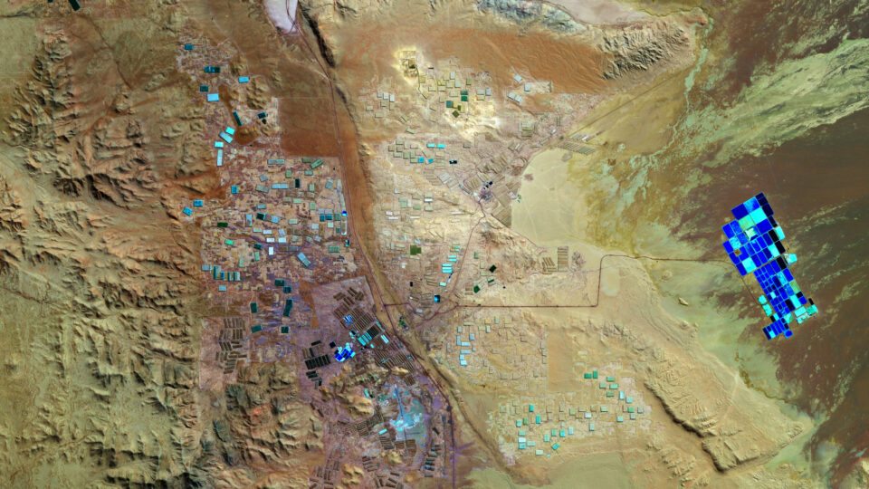
The system is called VolcSARvatory and makes use of interferometric synthetic aperture radar to detect ground movement changes as small as one centimeter.  It utilizes two or more radar images from satellites taken at different times.  The images are used to create a time series of data from a single location.

The system has been in operation since early 2022 and proved to be valuable in studying the unexpected activity at the long-quiet Mount Edgecumbe volcano near Sitka, Alaska where conventional monitoring was not taking place.

According to the researchers, the technology has evolved to the point where it can be operational at a national level.  The goal is to provide a consistent approach to monitoring active volcanoes.

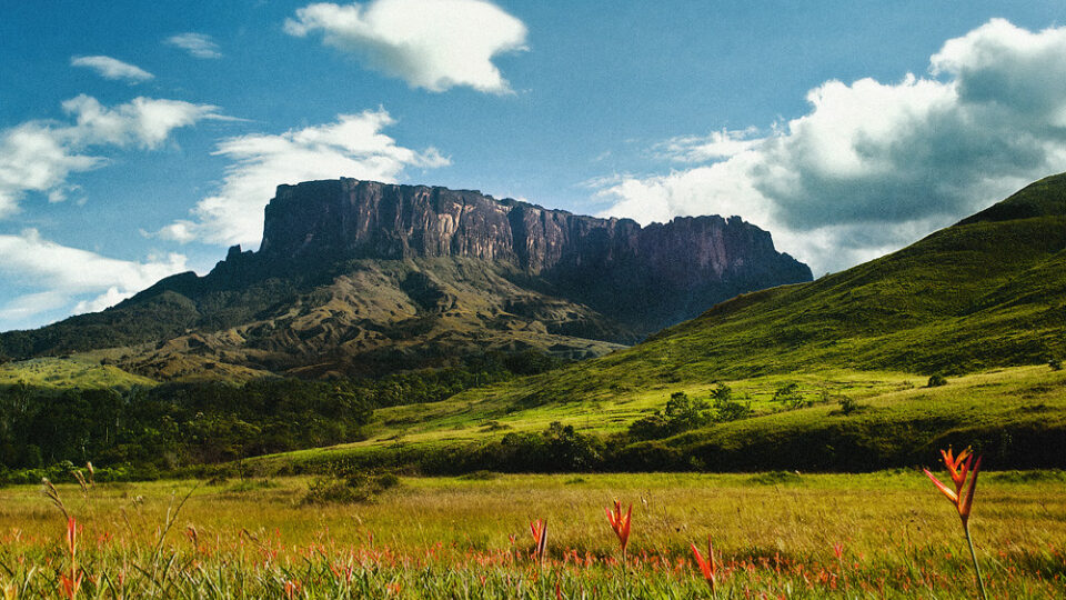
Volcanoes are not a rare and unlikely source of potential danger in this country.  The volcanoes of Hawaii are the best-known active volcanoes in the United States, but Alaska has about 140 volcanoes that are technically classified as active, with more than 50 that have been active within the past 300 years.  In total, 169 U.S. volcanoes are classified as active including ones in Arizona, California, Colorado, Idaho, Nevada, New Mexico, Oregon, Utah, Washington and Wyoming.

**********

Web Links

Alaska-developed volcano monitoring system will expand across U.S.

Photo, posted March 18, 2013, courtesy of Jeffrey Wickett / USFS via Flickr.

Earth Wise is a production of WAMC Northeast Public Radio

Lithium in Arkansas

November 28, 2024 By EarthWise Leave a Comment

Exploring lithium in Arkansas

Lithium is the critical raw material in the batteries that power electric cars as well as cell phones, computers, and other gadgets.  The stuff has been nicknamed “white gold” for good reason.  Chile and Australia are the world’s largest producers of the metal, which is mostly extracted from brine in evaporation ponds.  The majority of it is then processed in China.  The energy industry has been increasingly working to produce the raw materials needed to produce lithium-ion batteries in the United States and process those materials domestically.  There are multiple projects at various stages across the country.

Researchers at the US Geological Survey and the Arkansas state government recently announced that they have discovered a vast trove of lithium in an underground brine reservoir in Arkansas.

With a combination of water testing and machine learning, the researchers determined that there could be 5 to as much as 19 million tons of lithium in the geological area called the Smackover Formation.  This is more than enough to meet all the world’s demand for it.

Several companies – including Exxon Mobil, which is covering its bets on the future of oil as an energy source – are developing projects in Arkansas to produce lithium.  If these companies can develop and scale up economical new ways to extract lithium from salty water, the region in Arkansas could become the lithium capital of the world.

Energy and mining companies have produced oil, gas, and other natural resources in the Smackover Formation, which extends from Texas to Florida.  The same brines have long been the source of other valuable substances. 

**********

Web Links

Arkansas May Have Vast Lithium Reserves, Researchers Say

Photo, posted May 22, 2020, courtesy of the European Space Agency via Flickr.

Earth Wise is a production of WAMC Northeast Public Radio

PFAS and groundwater

November 26, 2024 By EarthWise Leave a Comment

PFAS in groundwater in the United States is widespread

Per- and polyfluoroalkyl chemicals, more commonly known as PFAS, are a family of human-made chemicals that have been manufactured and used in a variety of industries since the 1940s.  They provide water-resistance, oil-resistance, dirt-resistance, and corrosion-resistance to a wide range of products, including food wrappers and packaging, clothing, dental floss, nonstick cookware, textiles, and electronics.

Exposure to PFAS has been linked to birth defects, thyroid disease, liver disease, kidney disease, and cancer.  These chemicals do not break down in the environment and therefore, over time, become concentrated in plants, animals, and people. 

According to a new first-of-its kind study by scientists at the U.S. Geological Survey, more than 20% of the U.S. population could be drinking groundwater contaminated with PFAS.  The study, which was recently published in the journal Science, found that those living in the Eastern U.S. are particularly likely to be exposed.

The study is the first to report national estimates of PFAS in untreated groundwater that supplies drinking water to private and public wells. The USGS research also provides the first estimate of the total number of Americans – anywhere from 71 to 95 million – who might be exposed to this contamination.

The researchers note that their estimates merely measure the existence of PFAS – before the water has undergone any treatment or filtering – meaning that, while they may be present, they may be at very low levels. 

To find a link to the detailed USGS map showing the probability of PFAS groundwater contamination in your region, visit our website: EarthWiseRadio.org.

**********

Web Links

PFAS in US Groundwater Interactive Dashboard

Predictions of groundwater PFAS occurrence at drinking water supply depths in the United States

Photo, posted January 12, 2008, courtesy of Andrew Kraker via Flickr.

Earth Wise is a production of WAMC Northeast Public Radio

Glaciers in Venezuela

June 24, 2024 By EarthWise Leave a Comment

There are nearly 200,000 glaciers in the world.  About 91% of them are in Antarctica and 8% in Greenland.  The rest are scattered across nearly 50 countries.  The non-polar country with the most glaciers is actually Pakistan, which has over 7,200 of them.  But as the world continues to warm, glaciers are shrinking back, and many are disappearing altogether.

Venezuela, once home to six glaciers, has become the first country in the Americas to lose all of its glaciers.  Slovenia is considered to be the first country to lose its glaciers in modern times, perhaps as long as 30 years ago.  Glacial thawing has been worsening over the past decade throughout the Andes, which cover parts of Colombia, Venezuela, Bolivia, Ecuador, Peru, Chile, and Argentina.

Five of Venezuela’s glaciers had largely melted away by 2011.  The Humboldt glacier, which is on the highest peak in the Cordillera de Mérida mountain range in Venezuela, has now been declared as too small to be classified as a glacier.  It once covered over a thousand acres; it now has less than 5 acres of ice.  The US Geological Survey defines glaciers as ice bodies extending 25 acres or more.

The loss of glaciers in the Andes has serious consequences for communities that live on their slopes and depend upon glacial melt for water and for energy and food production. 

At least 80% of glaciers worldwide are on track to mostly disappear by the year 2100 because of global warming.  Given that previous forecasts estimated that the Humboldt glacier might last another decade, the prospects for the world’s remaining glaciers are not good.

**********

Web Links

Venezuela becomes first nation in the Americas to lose all glaciers

Photo, posted November 11, 2012, courtesy of Tim Snell via Flickr.

Earth Wise is a production of WAMC Northeast Public Radio

Groundwater and climate change

February 22, 2024 By EarthWise Leave a Comment

Groundwater is the vast reserve of water beneath Earth’s surface.  It’s an essential resource for humans, plants, animals, and other living organisms.  According to the United States Geological Survey, about 30% of all readily available freshwater in the world is groundwater.  In areas lacking sufficient surface water supply from rivers and reservoirs,  groundwater is critical for meeting the region’s drinking water and food production needs.

But climate change, as well as global population growth, is stressing groundwater resources.  As precipitation becomes less reliable due to climate change, surface water bodies can drop too low to provide the needed water.  As a result, people turn to groundwater. Depletion of groundwater is already a significant problem, and over-pumping will only increase further as climate change makes traditional sources of water less reliable.

According to a new study led by researchers from the University of Michigan, farmers in India have adapted to warming temperatures by intensifying the withdrawal of groundwater used for irrigation.  The study, which was published in the journal Science Advances, found that the rate of groundwater loss could triple by 2080 if this trend continues, further threatening India’s food and water security. 

India is the second-largest global producer of common cereal grains such as rice and wheat, and recently passed China as the world’s most populous nation. Without interventions to conserve groundwater, the research team finds that warming temperatures will likely amplify India’s groundwater depletion problem, further threatening the country’s food and water security.  

********** 

Web Links

Groundwater depletion rates in India could triple in coming decades as climate warms, study shows

Where is Earth’s Water?

Photo, posted August 2, 2013, courtesy of Rajarshi MITRA via Flickr.

Earth Wise is a production of WAMC Northeast Public Radio

California Flooding | Earth Wise

February 2, 2023 By EarthWise Leave a Comment

Devastating flooding kicks off the new year in California

Starting in December, a series of “atmospheric rivers” brought record storms to California producing as much rain in three weeks in some areas as they normally have in an entire year.  The historic levels of rain (and snow in the mountains) have swollen rivers, flooded roads and homes, forced evacuations, knocked out electric power for millions of people, and resulted in more than 20 deaths.

Atmospheric rivers are air currents that carry large amounts of water vapor through the sky.  They are not unusual for California but recurrent waves of them like those that have happened recently are very infrequent.  Studies by the U.S. Geological Survey have shown that such a phenomenon recurs in California every 250 years.  There were a series of storms causing disastrous floods in California in 1861-62.

The atmospheric rivers are born in the warm waters of the tropical Pacific.  During La Nina phases, the atmospheric rivers typically make landfall on the northern West Coast. During El Nino phases, atmospheric rivers are more likely to end up in Southern and Central California. During transitions between the phases, as is happening now, the storms can cover large parts of the state.

Modern forecasting is pretty good at predicting the forthcoming occurrence of these storms and has led to some helpful actions, such as reservoir operators preventing dams from overflowing or bursting.  But there is a gap between science and decision-making.  It is pretty clear what needs to be done when tornados or hurricanes are on the way.  It is less clear what actions are appropriate when there are going to be repeated heavy rainstorms.

These storms will have an effect on California’s megadrought, but just how much of an effect remains to be seen.

**********

Web Links

Flooding in California: What Went Wrong, and What Comes Next

Photo, posted January 5, 2023, courtesy of Sarah Stierch via Flickr.

Earth Wise is a production of WAMC Northeast Public Radio

Harnessing The Smell Of Fear | Earth Wise

September 28, 2021 By EarthWise Leave a Comment

Harnessing the smell of fear to drive away pests

Plant-eating insects present a major problem for farmers and home gardeners.  Aphids, for example, are a highly destructive pest to many crops.  Their large numbers and ability to transmit plant pathogens make them a persistent problem for growers.

Pesticides are chemical substances that are commonly used to prevent, destroy, repel or mitigate pests.  They include insecticides for insects, rodenticides for rodents, herbicides for weeds, and fungicides for microorganisms.  According to the U.S. Geological Survey, approximately one billion pounds of these chemicals are used in the United States every year.     

But pesticides can also contaminate soil, water, and other vegetation, as well as kill many non-target species.  Exposure to these chemicals is dangerous for human health. 

According to a new study, researchers from Pennsylvania State University have developed a way to bottle the “smell of fear” produced by predators in order to repel and disrupt pests naturally without the need for these harsh substances.  The researchers recently presented their findings at the American Chemical Society meeting.  

Aphids happen to be a favorite food of ladybugs. Aphids and other herbivorous insects will steer clear of fields and gardens if they smell predators nearby.  The researchers identified and extracted the volatile odor profile from ladybugs.  The researchers used the compounds to create a special odor blend that can be used in an essential oil diffuser to spread the scent across a garden or field. 

The research team plans to conduct field tests to see if the effects outside are similar to what was observed in the lab.  A natural and effective pest repellent would be a big win for people and the planet.  

**********

Web Links

Protecting gardens and crops from insects using the ‘smell of fear’

Protecting gardens and crops from insects using the ‘smell of fear’ (YouTube)

Photo, posted May 10, 2011, courtesy of DM via Flickr.

Earth Wise is a production of WAMC Northeast Public Radio.

Snakes Near A Plane | Earth Wise

September 15, 2021 By EarthWise Leave a Comment

San Francisco International Airport is the seventh-busiest airport in the United States.  In a typical year, approximately 55 million people pass through SFO on their way to destinations throughout North America and beyond.

At some point during their journey to or from the terminals at SFO, each one of those people will pass by a seemingly unremarkable 180-acre parcel of land.  Surrounded by highways and train tracks, the soggy and overgrown vacant lot isn’t just home to rows of power lines.  It’s also home to the world’s largest population of the beautiful and highly endangered San Francisco garter snake.   

According to a recent study conducted by the U.S. Geological Survey, there are approximately 1,300 San Francisco garter snakes at SFO’s West of Bayshore property – the greatest concentration of these snakes ever recorded.

Conservationists have long known that the San Francisco garter snake was in trouble.  In fact, it landed on the U.S. Fish and Wildlife Service’s very first endangered species list, which was published in 1967.  Over the years, agricultural, commercial, and urban development have destroyed much of its wetland habitat, as well as much of its primary food source, the California red-legged frog.  The snakes have also been a popular target for poachers and collectors.

Since 2008, SFO has been working with the USFWS on a recovery strategy for the species.  Together, they’ve made enhancements to the West of Bayshore habitat, including building rainfed ponds and deepening existing wetlands.  They have also added fences to protect habitat and prevent illegal collection.

But low population counts at other locations means the recovery for the San Francisco garter snake is far from over. 

************

Web Links

Combining genetic and demographic monitoring better informs conservation of an endangered urban snake

A San Francisco Airport Site Is Crawling With Snakes—And That’s a Good Thing

Photo, posted April 16, 2011, courtesy of Brian Gratwicke via Flickr.

Earth Wise is a production of WAMC Northeast Public Radio.

Growing Rocks To Store Carbon

April 24, 2019 By EarthWise Leave a Comment

The US Geological Survey recently published a comprehensive review of geological carbon storage in sedimentary rocks through carbon mineralization.   That is the process by which carbon dioxide becomes a solid mineral, such as a form of carbonate.  Certain rocks undergo a chemical reaction when exposed to carbon dioxide and turn into different minerals as a result.

The idea is to use carbon mineralization as a way to permanently store carbon dioxide that has been captured from power plant emissions, other industrial activities, or even directly from the atmosphere.

Two basic approaches are injecting the CO2 deep underground or exposing it to crushed rocks at the surface.  The two types of rock best suited for mineralization through injection are basalt and various ultramafic rocks.  Pilot studies have shown that injection into basalt can lead to mineralization in under two years.

Exposing carbon dioxide to crushed rock at the surface generally makes use of crushed mining waste.  Mineralization can be much faster in this case because there is more surface area on the crushed rock where mineralization occurs.  (However, the quantities of rock available at the surface are much less than what exists deep underground).

Like all carbon capture and storage approaches, the key consideration is cost.  The USGS study estimates that underground injection would cost around $30 per metric ton of CO2.  The crushed rock approach might only cost $8 per metric ton, but that assumes the crushed rock is already available.  If it must be newly mined, the costs would obviously go up significantly.  To put this into perspective, a typical car produces around 4 metric tons of CO22 per year.  So, it would cost somewhere between $30 and $120 a year to eliminate the emissions from one car.  Perhaps that is a price we need to pay until we ditch gasoline cars.

**********

Web Links

How Growing Rocks Can Help Reduce Carbon Emissions

Photo, posted October 17, 2011, courtesy of Glen Bledsoe via Flickr.

Earth Wise is a production of WAMC Northeast Public Radio.

Salt Cocktails Compromise Freshwater

August 1, 2018 By EarthWise Leave a Comment

https://earthwiseradio.org/wp-content/uploads/2018/07/EW-08-01-18-Salt-Cocktails.mp3

Human activities are exposing US rivers and streams to a cocktail of salts, with consequences for infrastructure and drinking water supplies. Road salt, fertilizers, and mining waste – as well as natural weathering of concrete, rocks, and soils – all contribute to increased salt in waterways. When these different salt compounds combine, their harmful effects can amplify.

[Read more…] about Salt Cocktails Compromise Freshwater

Earthquake Warning System

October 11, 2017 By EarthWise Leave a Comment

https://earthwiseradio.org/wp-content/uploads/2017/10/EW-10-11-17-Earthquake-Warning-System.mp3

The destructive power of both hurricanes and earthquakes has made headlines in recent times.   The slow development of the hurricanes in the Atlantic was monitored for days before they wreaked havoc on Caribbean islands and Florida cities.  Earthquakes, on the other hand, occur suddenly and without warning.   Except, that isn’t entirely true.

[Read more…] about Earthquake Warning System

The Terminology Of Extreme Weather

September 19, 2017 By EarthWise Leave a Comment

https://earthwiseradio.org/wp-content/uploads/2017/09/EW-09-19-17-The-Terminology-of-Extreme-Weather.mp3

We often hear the terms “100-year” and “500-year” used to describe instances of extreme flooding.  But as the climate changes, these extreme weather events are expected to become more frequent.  So what’s with the terminology then anyways? 

[Read more…] about The Terminology Of Extreme Weather

Human-Caused Earthquakes

May 10, 2016 By WAMC WEB

https://earthwiseradio.org/wp-content/uploads/2016/05/EW-05-10-16-Human-Caused-Earthquakes.mp3

Oklahoma has had its share of disasters over the years.  It has seen tornado outbreaks, massive wildfires, huge dust storms and even onslaughts of tumbleweeds.  But one thing it was not known for is earthquakes.

[Read more…] about Human-Caused Earthquakes

Primary Sidebar

Recent Episodes

  • An uninsurable future
  • Clean energy and jobs
  • Insect declines in remote regions
  • Fossil fuel producing nations ignoring climate goals
  • Trouble for clownfishes

WAMC Northeast Public Radio

WAMC/Northeast Public Radio is a regional public radio network serving parts of seven northeastern states (more...)

Copyright © 2026 ·