• Skip to primary navigation
  • Skip to main content
  • Skip to primary sidebar

Earth Wise

A look at our changing environment.

  • Home
  • About Earth Wise
  • Where to Listen
  • All Articles
  • Show Search
Hide Search
You are here: Home / Archives for reservoirs

reservoirs

More floating solar

September 25, 2025 By EarthWise Leave a Comment

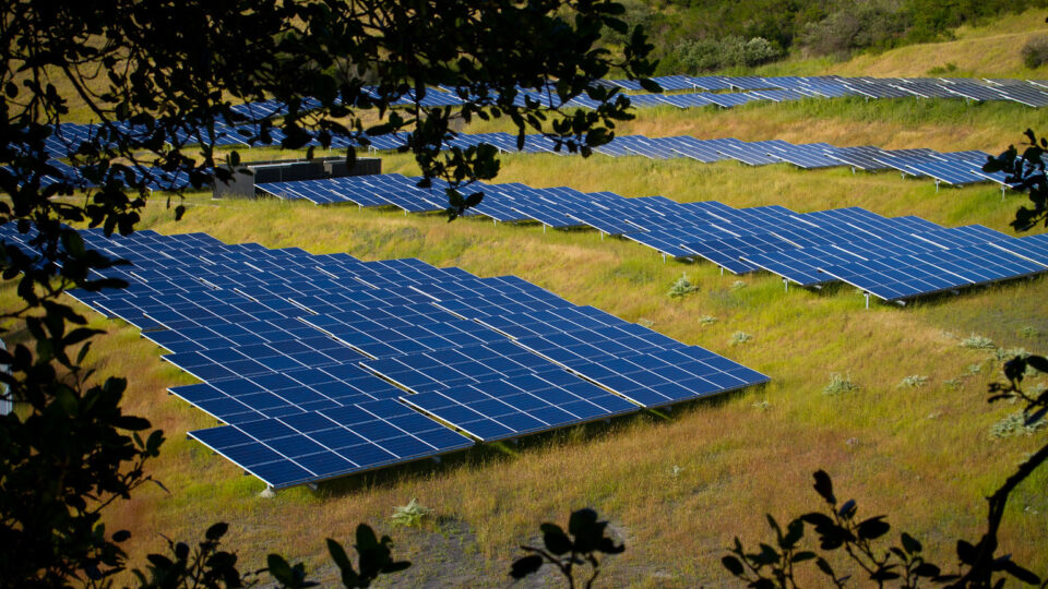
Floating solar power is starting to gain some traction in the United States.  Installing solar panels on rafts so that they float on water instead of sitting on land allows them to not take up land that can be used for other purposes.  There are other benefits as well.

The world’s largest floating solar farm is one in Shandong, China, and produces 320 MW of power.  Floating solar has been common in Asia for years.  To date, floating solar only makes up a tiny fraction of the installed solar power in the U.S. and is mostly limited to small-scale projects.  The largest in the U.S. is the 8.0 MW Canoe Brook Water Treatment Plant in Millburn, NJ.  A floating solar array in the water reservoir at the Cohoes Water Filtration Plant in New York’s Capital Region is currently under construction.  A 6-MW floating solar system is now being built in the Village of Monroeville, Ohio.

Floating solar systems have the advantage that covering the surface of reservoirs dramatically reduces the amount of evaporation that occurs, which is a real benefit in drought-stricken regions like California.  In addition, proximity to the large body of water keeps solar panels cool, which allows them to generate more electricity than their land-based counterparts.

Estimates are that federally controlled reservoirs alone have the potential to host roughly 1,000 GW of floating solar capacity.  It is more expensive to install them than conventional land-based solar and floating solar competes with recreational use of bodies of water.  Nonetheless, the floating solar market is expected to grow significantly in the coming years.

**********

Web Links

Ohio’s largest floating solar array is now under construction

Photo, posted May 28, 2025, courtesy of Mike Popp / University of Arkansas via Flickr.

Earth Wise is a production of WAMC Northeast Public Radio

Hidden hydrogen

July 15, 2025 By EarthWise Leave a Comment

The idea of using hydrogen as a fuel or an energy source has been around for a long time.  Hydrogen is the most common element in the universe, but most of it is locked up in various chemical compounds, such as water.  Hydrogen is a clean fuel; burning it or using it to generate electricity in a fuel cell produces no greenhouse gas emissions.  But more than 99% of the hydrogen that people current produce is obtained by methods that result in greenhouse gas emissions.

A new study by scientists at the University of Oxford, the University of Durham in the UK, and the University of Toronto looks at geological environments in which naturally occurring hydrogen could be hiding.  According to the study, over the last billion years, the Earth’s continental crust is likely to have produced enough hydrogen to satisfy the energy needs of modern society for 170,000 years.

Much of that hydrogen is likely to have been lost or is inaccessible; most of it is not economically feasible to extract.  But even the relatively small amount of hydrogen left could provide thousands of years of energy for us.  We just have to be able to find it.

The researchers have developed what they call an “exploration recipe” which identifies where natural hydrogen might be located as well as where it could be commercially feasible to extract.  These places with hydrogen have so-called reservoir rocks and geologic formations that prevent the gas from leaking into the atmosphere.

A few such places have already been identified such as one in Albania.  There are various candidates to explore, even including an area in Kansas.  The study’s authors have founded a company whose mission is to find these natural sources of hydrogen.

**********

Web Links

Scientists Say Hidden Hydrogen Could Power the World for 170,000 Years

Photo, posted October 4, 2019, courtesy of Tony Sprezzatura via Flickr.

Earth Wise is a production of WAMC Northeast Public Radio

Coexisting birds and solar energy

June 23, 2025 By EarthWise Leave a Comment

Floating photovoltaic systems – known as floatovoltaics – are becoming increasingly popular.  These are arrays of solar panels installed over artificial water bodies such as irrigation ponds, wastewater treatment plants, and reservoirs.  These projects maximize the space for producing clean energy while not taking up natural lands.

Wherever there are bodies of water, there are waterbirds.  A recent study by researchers at the University of California, Davis looked at the potential impact of floating solar projects on birds and other wildlife. 

Birds face many threats from habitat loss, climate change, pollution, and disease.  Many bird populations are in decline.  So, it is important to consider the effects of floating solar projects on birds. 

The researchers have observed birds resting on floating solar structures before dawn, birds jockeying for favorable sites on the structures, and some nesting under the panels.  These are positive interactions.  On the other hand, it is possible that pollutants could be released or leached from floating solar infrastructure.  Such risks must be mitigated.

Floating solar on irrigation ponds and reservoirs can reduce evaporation and reduce algae growth, which benefits both humans and wildlife.

The researchers will continue to monitor bird behavior at floating solar installations using expertise in ecology and energy system science to identify risks and solution pathways so that negative impacts are avoided, and potential ecological benefits are realized.  It is important that as floating solar continues to become more popular, it and waterbirds can coexist.

**********

Web Links

Helping Birds and Floating Solar Energy Coexist

Photo, posted February 28, 2019, courtesy of Renee Grayson via Flickr.

Earth Wise is a production of WAMC Northeast Public Radio

The green grab for land

March 27, 2025 By EarthWise Leave a Comment

Solar and wind farms are spreading rapidly around the world.  Many economists believe that solar power has crossed the threshold where it is generally cheaper than other ways to make electricity and will become the dominant energy source in the next couple of decades.  As a result, both solar and wind farms are gobbling up more and more land around the world.  Estimates are that they will take up around 30,000 square miles by mid-century.

One concern is whether we are entering an era of trading food for energy.  Land conflicts seem inevitable since solar power operates best in unshaded areas with gentle winds and moderate temperatures, which are the same conditions favored by many crops.

China is installing more solar farms than the rest of the world combined.  Many of these are in the Gobi Desert, where there is no competing need for the land.  But some are in eastern China, in densely populated grain-growing areas.

There are a number of strategies that reduce the impact of solar farms on land use.  One approach is to put them on old industrial or brownfield sites that are otherwise unusable.  Another is floatovoltaics:  putting solar panels on the surface of lakes and reservoirs.  And then there is agrivoltaics, where solar panels are installed above crop fields or where livestock graze between or even beneath solar arrays.  China has more than 500 agrivoltaic projects that incorporate crops, livestock, aquafarming, greenhouses, and even tea plantations.

Green energy has both environmental and economic benefits to offer, but it must conserve nature and not excessively grab land needed for people, wildlife, and ecosystems.

***********

Web Links

‘Green Grab’: Solar and Wind Boom Sparks Conflicts on Land Use

Photo, posted May 25, 2011, courtesy of Michael Mees via Flickr.

Earth Wise is a production of WAMC Northeast Public Radio

Drying rivers and hydropower

February 7, 2025 By EarthWise Leave a Comment

Drying rivers threaten hydropower around the world

A decade ago, Ecuador began a major transition to using hydroelectric power.  Like in many other South American countries, the presence of abundant rivers could supply large amounts of energy and drive economic expansion and lead to a new era of prosperity.

This ambitious plan has run into the impacts of climate change.  An extraordinary drought has engulfed much of South America, drying rivers and reservoirs, and has put Ecuador’s power grid on the brink of collapse. 

Since September, daily energy cuts in Ecuador have lasted as long as 14 hours.  An industry group says that the nation is losing $12 million in productivity and sales for every hour the power is out.  Just a few years ago, Ecuador was making great strides in reducing poverty.  Now, as the energy crisis has increased its grip on the country, much of what was achieved is being lost.

Ecuador’s situation is not unique.  In recent years, abnormally dry weather in multiple places has resulted in extreme low water levels in rivers, reducing hydropower resources in Norway, Canada, Turkey, and even rainforest-rich Costa Rica.

Overall, more than one billion people live in countries where more than half of their energy comes from hydroelectric plants.  With a warming climate and increasing incidence of extreme weather events like drought, it is likely that hydropower will become a less reliable energy source.  More than a quarter of all hydroelectric dams are in places with a medium to high risk of water scarcity by 2050. 

**********

Web Links

The Rivers Run Dry and the Lights Go Out: A Warming Nation’s Doom Loop

Photo, posted January 15, 2020, courtesy of Pedro Szekely via Flickr.

Earth Wise is a production of WAMC Northeast Public Radio

The Colorado River crisis

May 15, 2024 By EarthWise Leave a Comment

The Colorado River serves nearly 40 million people in seven U.S. states and Mexico.  It provides water for 5 million acres of farmland.  Increasing demand from growing populations, damming, diversion, and drought have been draining the Colorado at alarming rates.  This critical resource supports countless economies, communities, and ecologies stretching from the Rocky Mountains to the Gulf of California.  The Colorado River essentially has made the cities of Las Vegas, Los Angeles, Denver, and Phoenix possible.

How the water of the Colorado is distributed is determined by an agreement that is over 100 years old:  the Colorado River Compact.  It was made at a time when people thought there was more water than really was there.  And at the time, no one thought that the seven states would need to use the water they were allocated down to the last drop.

There have been various measures over the years to conserve water from the Colorado River, including the Colorado River Interim Guidelines in 2007.  Those guidelines will expire in 2026 and negotiations are beginning to take place among the many stakeholders scrambling for water rights.  Apart from the seven U.S. states and Mexico, there are 30 tribal nations involved.  Collaborative governance is complicated when it crosses multiple jurisdictions with their own laws and legal precedents.  The goal is to put in place a new agreement to protect the Colorado River.

Rapidly-growing populations in major cities, a 20-year megadrought, and historically low water levels in America’s two largest reservoirs have put enormous pressure on the Colorado River.  Creating a plan to protect the lifeblood of the American West is essential.

**********

Web Links

Addressing the Colorado River crisis

Photo, posted June 18, 2022, courtesy of Jeff Hollett via Flickr.

Earth Wise is a production of WAMC Northeast Public Radio

How to make cities cooler

March 26, 2024 By EarthWise Leave a Comment

Green spaces and waterways help keep cities cool

In cities, the air, surface, and soil temperatures are almost always warmer than in rural areas. This is known as the urban heat island effect.  Urban heat islands occur when cities replace natural land cover with dense concentrations of pavement, buildings, and other surfaces that absorb and retain heat.

Urban planners around the world have been researching ways to reduce the effects of heat in cities.  For example, trees, green roofs, and vegetation can help reduce urban heat island effects by shading building surfaces, deflecting radiation from the sun, and releasing moisture into the atmosphere.

A new study led by researchers from the University of Surrey in the U.K. has analyzed how well various green spaces and waterways are able to cool down cities.  The study, which was recently published in the journal The Innovation, found that wetlands, parks, and even botanical gardens are among the best ways to keep cities cool.   

In fact, the researchers found that botanical gardens can cool city air by a whopping 9°F during heatwaves on average.  Wetlands can cool city air by 8.5°F on average, followed by rain gardens at 8.1°F, green walls at 7.4°F, street trees at 6.8°F, city farms at 6.3°F, city parks at 5.8°F, and reservoirs and playgrounds at 5.2°F. 

The researchers also found that cities can unlock even greater benefits by connecting green spaces into green corridors.  Greening projects can also help remove carbon emissions and prevent flooding.

The research team hopes its findings will help urban planners design more resilient cities. 

**********

Web Links

Wetlands, parks and even botanical gardens among the best ways to cool cities during heatwaves

Photo, posted April 25, 2022, courtesy of Catherine Poh Huay Tan via Flickr.

Earth Wise is a production of WAMC Northeast Public Radio

Groundwater and climate change

February 22, 2024 By EarthWise Leave a Comment

Groundwater is the vast reserve of water beneath Earth’s surface.  It’s an essential resource for humans, plants, animals, and other living organisms.  According to the United States Geological Survey, about 30% of all readily available freshwater in the world is groundwater.  In areas lacking sufficient surface water supply from rivers and reservoirs,  groundwater is critical for meeting the region’s drinking water and food production needs.

But climate change, as well as global population growth, is stressing groundwater resources.  As precipitation becomes less reliable due to climate change, surface water bodies can drop too low to provide the needed water.  As a result, people turn to groundwater. Depletion of groundwater is already a significant problem, and over-pumping will only increase further as climate change makes traditional sources of water less reliable.

According to a new study led by researchers from the University of Michigan, farmers in India have adapted to warming temperatures by intensifying the withdrawal of groundwater used for irrigation.  The study, which was published in the journal Science Advances, found that the rate of groundwater loss could triple by 2080 if this trend continues, further threatening India’s food and water security. 

India is the second-largest global producer of common cereal grains such as rice and wheat, and recently passed China as the world’s most populous nation. Without interventions to conserve groundwater, the research team finds that warming temperatures will likely amplify India’s groundwater depletion problem, further threatening the country’s food and water security.  

********** 

Web Links

Groundwater depletion rates in India could triple in coming decades as climate warms, study shows

Where is Earth’s Water?

Photo, posted August 2, 2013, courtesy of Rajarshi MITRA via Flickr.

Earth Wise is a production of WAMC Northeast Public Radio

Lakes Are Shrinking | Earth Wise

September 11, 2023 By EarthWise Leave a Comment

A study by the University of Colorado Boulder has found that more than half of the world’s largest lakes have shrunk over the last three decades.  This is a very big problem because about one-quarter of the Earth’s population lives in the basin of a drying lake.  People depend on lakes for drinking water and irrigation and lakes are central to the survival of local ecosystems as well as migrating birds.  Lakes cover only about 3% of the planet, but they hold nearly 90% of the liquid surface freshwater.

The study used satellite observations from 1992 to 2020 to estimate the area and water levels of nearly 2,000 freshwater bodies.  These account for 96% of Earth’s total natural lake storage and 83% of that in man-made reservoirs.  About 53% of the world’s lakes have clearly shrunk, while only 22% have gained water.  The study estimates that about 160 trillion gallons of water has been lost over the 28-year period.  That’s about 17 times the maximum capacity of Lake Mead, the largest reservoir in the United States.

Many of the world’s most significant lakes have been shrinking. The dramatic declines in Lake Mead have been headline news for years.  The Caspian Sea, which is the world’s largest inland body of water – has long been declining.

The main causes of the decline in natural lakes are climate change and human consumption.  Reservoirs face an additional major problem of sediment buildup which reduces their storage capacity and diminishes their benefits of water supply, flood control, and hydropower.

Lake loss is a big problem.

**********

Web Links

More than half of the world’s largest lakes are drying up

Photo, posted April 10, 2018, courtesy of Ninara via Flickr.

Earth Wise is a production of WAMC Northeast Public Radio

Plastic In Lakes | Earth Wise

August 28, 2023 By EarthWise Leave a Comment

We are always talking about the millions of tons of waste plastic that finds its way into the oceans and about the challenges of trying to remove it.  A new multinational study has found that the concentration of plastics and microplastics in some lakes is even worse than in the so-called garbage patches in the oceans and some of these lakes are even in remote places around the world

Scientists from institutes in multiple countries collected water samples from 38 lakes and reservoirs in 23 countries across six continents.  The samples were then all analyzed by the University of Milan to assess the presence of plastic particles more than a quarter millimeter in size.

The study found that two types of lakes are particularly vulnerable to plastic contamination:  lakes and reservoirs in densely populated and urbanized areas and large lakes with elevated deposition areas, long water-retention times, and high levels of human influence.

Lakes found to have the highest concentration of plastic included some of the main sources of drinking water for communities and were also important to local economies.  These included Lough Neagh in Northern Ireland, Lake Maggiore in Italy, and Lake Tahoe on the California/Nevada border.  Not all the lakes studied contained large amounts of plastic.  For example, Windermere, the largest lake in England, had very low concentrations of plastic in surface water.

This was the first global survey of the abundance and type of plastic pollution in lakes and reservoirs and the scale of freshwater plastic pollution is sobering indeed.  There is widespread concern that plastic debris is having harmful effects on aquatic species and ecosystem function and clearly is not limited to marine ecosystems.

**********

Web Links

Plastic pollution is higher in some lakes than oceans

Photo, posted May 27, 2019, courtesy of Jonathan Cook-Fisher via Flickr.

Earth Wise is a production of WAMC Northeast Public Radio

Solar Panels On Canals | Earth Wise

August 25, 2023 By EarthWise Leave a Comment

There has been growing interest in installing solar panels on top of reservoirs to make use of the available space to make electricity and reduce evaporation.  There has been far less interest in installing solar on canals and aqueducts.  But that is changing and a new project in California is part of that change.

A study by the University of California, Merced estimates that 63 billion gallons of water would be saved by covering California’s 4,000 miles of canals with solar panels.  All that installed solar would generate a significant amount of electricity.

The idea is going to be tested in the Turlock Irrigation District in Central California with Project Nexus, which is the installation of solar panels over 1.8 miles of canals that are between 20 and 110 feet wide.  The panels will sit between 5 and 15 feet off the ground.  UC Merced researchers will study impacts ranging from evaporation to water quality and use the results to make recommendations with respect to wider use of the technology.

California isn’t the first place to put solar on a canal.  India pioneered it on one of the largest irrigation projects in the world.  The Sardar Sarovar dam and canal project brings water to hundreds of thousands of villages in the dry, arid region of India’s Gujarat State.

Meanwhile, the Gila River Indian Community in Arizona received funding from the Bipartisan Infrastructure Law to install solar panels on their canals in an effort to save water and reduce stress on the struggling Colorado River.

The world of water infrastructure does not embrace change easily but covering canals with solar panels is an idea whose time may have come.

**********

Web Links

Solar panels on water canals seem like a no-brainer. So why aren’t they widespread?

Photo, posted December 11, 2005, courtesy of Dave Parker via Flickr.

Earth Wise is a production of WAMC Northeast Public Radio

Floating Solar And Hydropower | Earth Wise

August 16, 2023 By EarthWise Leave a Comment

Installing solar panels on the surface of reservoirs is an up-and-coming trend.  The arrays of solar panels produce renewable energy while at the same time shielding significant expanses of water from the sun’s heat, thereby reducing evaporation.  The panels also help to inhibit the growth of algae.

Two recent floating solar installations are demonstrating the synergy between solar power and hydroelectric power.

The Lazer floating solar plant in France comprises over 50,000 solar panels and is capable of producing 30 MW of power.  The reservoir serves a 16.5 MW hydropower plant.  During the summer, the water from Lazer Reservoir is used primarily for crop irrigation and the solar plant supplements power generation as the reservoir water level experiences variations.  This is the first facility of its kind to be installed in France.  The company that built it – the EDF Group – had already built four floating solar power plants in Israel and the US. 

In Colombia, the Aquasol solar project is installed at the 340 MW Urrá hydropower plant.  Its 2,800 solar panels produce enough power to offset the amount of energy it takes to operate the dam.  The floating solar system is designed to withstand water-level fluctuations of up to 120 feet.

Floating solar systems can help keep power flowing when low water levels or other adverse conditions reduce hydroelectric output.  About 60% of the world’s renewable energy comes from hydropower.  Given this fact, there are countless opportunities to deploy floating solar that maximizes zero-emission energy generation as well as diversifying clean energy sources.

**********

Web Links

Floating solar and hydropower: A match made in renewable energy heaven

Photo, posted October 25, 2010, courtesy of Martin Abegglen via Flickr.

Earth Wise is a production of WAMC Northeast Public Radio

Large Lakes In Decline | Earth Wise

June 27, 2023 By EarthWise Leave a Comment

More than half of the world's largest lakes are shrinking

Globally, freshwater lakes and reservoirs hold 87% of the planet’s liquid freshwater, making them a valuable resource for both people and wildlife.  Despite their value, the long-term trends and changes to water levels of lakes have been largely unknown – until now.

According to a new assessment recently published in the journal Science, more than half of the largest lakes around the world are losing water.  Using satellite observations and climate data, the research team created a technique to measure changes in water levels in nearly 2,000 of the world’s biggest lakes and reservoirs, representing 95% of the total lake water storage on Earth.

The results are staggering.  According to the findings, 53% of Earth’s largest lakes and reservoirs now store significantly less water than they did in 1992.  The total amount of water lost is estimated to be 144.5 cubic miles, which is equivalent to the volume of 17 Lake Meads (the largest reservoir in the U.S.). 

Unsurprisingly, climate warming and human consumption were the main drivers of water loss from lakes, whereas sedimentation — the buildup of debris — was the biggest driver of water loss in reservoirs.  Roughly one-quarter of the world’s population – two billion people – live in the basin of a drying lake, indicating the urgent need for sustainable water resources management.

But the news is not entirely bleak.  According to the research team, the new method of tracking lake water storage trends can give water managers and communities insight into how to better protect this critical resource. 

**********

Web Links

Satellites reveal widespread decline in global lake water storage

Photo, posted February 10, 2010, courtesy of Ninara via Flickr.

Earth Wise is a production of WAMC Northeast Public Radio

Geothermal Energy Storage | Earth Wise

May 22, 2023 By EarthWise Leave a Comment

Aquifer thermal energy storage a solution to heat and cool buildings

About 12% of the energy consumed by humanity is used to heat and cool homes and businesses.  A study by researchers at Lawrence Berkeley National Laboratory and Princeton University looked at a novel approach to making use of underground water to maintain comfortable temperatures and reduce consumption of natural gas and electricity.

The idea is to use aquifer thermal energy storage (known as ATES) to provide both heat in the winter and cooling in the summer.  The concept leverages the heat-absorbing property of water and natural geological features.  The idea is to pump up water from existing underground reservoirs and heat it at the surface using environmental heat or even excess energy from solar or wind generation.  Then the warm water is pumped back down. It stays warm for a long time – even months – because the earth is a good insulator.  When the water is pumped back up in the winter, it is much hotter than the ambient air and can be used to supply heat to buildings.

Alternately, water can be pumped up and cooled in the winter and then put back down underground and stored until cooling is needed in the summer months.

This technology has not been used much in the US, but it is gaining recognition internationally, particularly in the Netherlands.  It can perform very well in areas with large seasonal fluctuations.

The research study used modeling and various simulations to estimate how much energy ATES could save on the US grid.  The results showed that adding ATES to the grid could reduce consumption of petroleum products for heating and  cooling by up to 40%.  The system could also help prevent blackouts by reducing high power demand during extreme weather events.

**********

Web Links

Underground Water Could be the Solution to Green Heating and Cooling

Photo, posted February 19, 2012, courtesy of Sanjay via Flickr.

Earth Wise is a production of WAMC Northeast Public Radio

Two Lost Lakes Return To California | Earth Wise

May 10, 2023 By EarthWise Leave a Comment

Two lost lakes return to California following recent rains

The recent siege of powerful storms in California driven by a series of atmospheric rivers has had a significant effect on the severe drought that has plagued most of the state for many years.  Many of the state’s reservoirs are at the highest level they have been for decades.   The snowpack in the Sierras is well over 200% of its historical average.  Many parts of the state are no longer considered to be in drought conditions, and, in fact, flooding has been a serious problem in some areas.  This flooding has had some surprising results.

Two California lakes that drained a century ago have reappeared as a result of floodwaters from the recent storms.

Tulare Lake, in California’s Central Valley used to be fed by rain and snowmelt from the Sierras.  A system of dams and canals constructed in the early 20th century to support regional agriculture diverted water away from the lake.  It used to be the largest freshwater lake in the West but farmers ultimate planted crops in the dried lakebed.

The atmospheric river events in March inundated that farmland and once again there is water in Tulare Lake.

Owens Lake, on the eastern side of the Sierra Nevada, was long fed by mountain streams.  The 1913 construction of the Los Angeles Aqueduct redirected water to that city and desiccated the lake.   Floodwaters in March caused a partial collapse of the aqueduct and when the spill gates on the aqueduct were opened to drain the damaged areas, floodwaters poured in and partially refilled the lake.

California has suffered from drought for many years.  With its massive snowpack, as the weather warms, the state may face even more flooding.

**********

Web Links

Two Long-Drained California Lakes Refilled by Floodwaters, Satellite Images Show

Photo, posted November 10, 2014, courtesy of CN via Flickr.

Earth Wise is a production of WAMC Northeast Public Radio

California: Drought Or No Drought? | Earth Wise

April 26, 2023 By EarthWise Leave a Comment

Despite heavy rains, California is still experiencing a drought

Just a few months ago, millions of people in California were living under challenging water conservation rules.  The past three years were the driest on record and reservoirs were depleted, landscapes dried up, and the snowpack in the Sierras at very low levels.

But in recent months, a dozen atmospheric river storms have brought huge amounts of rain and snow to the state.  Twelve out of 17 major reservoirs in the state have been replenished, the snowpack is over 240% of normal, and brown hills are blooming once again.

So, is the California drought over?  According to the experts, the answer is:  sort of.

The record snowpack and heavy rains have erased the most severe aspects of the drought in many parts of the state.  Only 9% of the state is now experiencing “severe” or “exceptional” drought, down from 55% last fall.

But the changes are basically all at the surface.  Groundwater in the state is still extremely low and the state’s cities and farms are still using more of it than is appropriate.  The state has been unwisely overusing its groundwater aquifers because of the drought and this one year of heavy rains cannot replenish levels that have been dropping for years.

California has been rolling back many of the most severe drought restrictions that had been imposed but has not entirely lifted the drought emergency status.  Meanwhile, the massive snowpack in the mountains will begin to melt as the weather warms and, in many areas, Californians will face flooding.  Water is a complicated business in California.

**********

Web Links

Drought or no drought? California left pondering after record winter deluge

Photo, posted August 28, 2019, courtesy of Joyce Cory via Flickr.

Earth Wise is a production of WAMC Northeast Public Radio

California Storms And The Megadrought | Earth Wise

February 22, 2023 By EarthWise Leave a Comment

California experienced its wettest 10-day period in 25 years as a result of a series of storms driven by atmospheric rivers in January.  The Rocky Mountains got buried in snow from the same weather pattern.   For the drought-stricken West, the storms were good news.  But they are not the cure for what’s been ailing the region.

In California, the snowpack in the Sierra Nevada mountains has been greatly enhanced, containing twice as much snow as is considered average for this time of year.  Without a doubt, it will reduce the impact of the drought that has plagued the state for 23 years.  But one big storm or even a series of them is not enough to undo years of minimal precipitation and rising temperatures.  Many of the states’ largest reservoirs remain well below historical averages despite the record-breaking rain.  It would take several wet years to really allow the state to recover from the drought.

The snowfall in the Rockies is crucial because it is the source of more than two-thirds of the water in the Colorado River.  The Colorado River is the water lifeline for 40 million people from Wyoming to Mexico.

The ongoing shrinking of the Colorado River is a crisis that has created massive problems for the multibillion-dollar agriculture industry and for many large cities, including Denver, Phoenix, Salt Lake City, Las Vegas, and Los Angeles.  Two of the nation’s largest reservoirs – Lake Mead and Lake Powell – are filled by the Colorado River.  The historic low levels of these reservoirs have threatened the functioning of hydropower facilities that provide electricity to millions of people.

The January storms were good news for the West, but its problems are not over.

**********

Web Links

This Winter’s Rain and Snow Won’t be Enough to Pull the West Out of Drought

Photo, posted September 18, 2022, courtesy of Sarah Stierch via Flickr.

Earth Wise is a production of WAMC Northeast Public Radio

Glacial Loss In The Swiss Alps | Earth Wise

December 14, 2022 By EarthWise Leave a Comment

Record glacial loss in the Swiss Alps

In 2022, glaciers in the Swiss Alps melted more than in any year on record.   This is the latest piece of bad news for the country’s glaciers, which have lost more than half of their volume of ice since the 1930s.

The melting season for Switzerland’s snow and ice typically starts in May and ends in early October.  This year’s melting season caused glaciers in the Diablerets mountain group to thin by an average of 13 feet, which is 3 times the amount of thinning observed over the past decade.   The Tsanfleuron pass between two of the glaciers is now exposed as bare rock for the first time in several thousand years. Across Switzerland, glaciers lost about 6% of their remaining volume just this year.  The previous worst year for glaciers was 2003, when losses were nearly 4%. 

There was significant melting this year in part because of the small amount of snowfall over the winter.  That snow melted quickly, being sped up by the warming effect of dust from the Sahara Desert falling on the snow.  By early summer, there was no longer a protective blanket of snow on the glaciers, exposing them to summer heat.

The loss of glaciers is far more serious than the disappearance of aesthetically pleasing landscape features.   Glaciers act as reservoirs of water that persist through the summer months.  Melt from glaciers provides water to ecosystems and creates habitats for plants and animals.  Cold runoff from glaciers affects downstream water temperatures which have a major impact on insects, fish, and other creatures.  Globally, melting glaciers contribute more than 20% of the observed ongoing sea-level rise.

**********

Web Links

Rocky Road for Swiss Glaciers

Photo, posted June 22, 2015, courtesy of Dennis Jarvis via Flickr.

Earth Wise is a production of WAMC Northeast Public Radio

The Bengal Water Machine | Earth Wise

October 31, 2022 By EarthWise Leave a Comment

Over the past three decades, the owners of 16 million small farms in the Bengal Basin of Bangladesh have been pumping shallow groundwater during dry seasons to irrigate rice paddies.  By lowering groundwater levels in this way during the dry season, the ability of leakage from rivers, lakes, and ponds to replenish the groundwater was greatly enhanced.   Capturing surface water not only improved the recovery of groundwater levels but only helped to reduce flooding during monsoons.

The net result of this enormous collective groundwater pumping by millions of farmers has been the creation of vast natural reservoirs underground that are comparable to what is contained by many of the world’s largest dams.   This system of sustaining irrigation has transformed what was previously a famine-prone country into a food-secure nation.

The details of this remarkable transformation have been laid out in a study by University College London recently published in the journal Science.  According to the study, over the course of 30 years, more than 75 cubic kilometers of fresh water was captured by this process, which is equivalent to the combined reservoirs of China’s Three Gorges Dam and the Hoover Dam in the U.S.

The authors of the study described the water cycling process as “The Bengal Water Machine” and argue that it can be a sustainable alternative to conventional approaches to seasonal river flow storage for irrigation, which typically involve dams and reservoirs.  Such approaches are difficult to implement in densely populated alluvial plains where sand, silt, and clay are laid down by annual floodwaters. 

**********

Web Links

Millions of farmers “replumb” world’s largest delta

Photo, posted February 2, 2010, courtesy of Melanie Ko via Flickr.

Earth Wise is a production of WAMC Northeast Public Radio

Climate Change And The Color Of Lakes | Earth Wise

October 19, 2022 By EarthWise Leave a Comment

According to a new study recently published in the journal Geophysical Research Letters, blue lakes around the world are at risk of turning green-brown if climate change continues unabated. 

For the study, the research team used over five million satellite images of more than 85,000 lakes and reservoirs around the globe between 2013 and 2020 in order to determine each lake’s most common water color.  Since lake color can change seasonally, the researchers assessed the most frequent lake color during those seven years. 

Algae and sediments affect the color of lakes.  But the study found that precipitation, air temperature, lake depth, and elevation also play major roles in determining a lake’s most common water color. 

The research team found that blue lakes account for less than one-third of lakes worldwide.  Blue lakes tend to be deeper and are often found in cool, high latitude regions with high precipitation and winter ice cover.  Meanwhile, green-brown lakes, which account for 69% of all lakes, are found in drier regions, continental interiors, and along coastlines. 

As global temperatures rise, lakes will warm, and warmer water produces more algal blooms.  As a result, the researchers expect the changing climate to decrease the percentage of blue lakes, many of which are found in the Rocky Mountains, northeastern Canada, northern Europe and New Zealand. 

Water color is a simple but viable way to measure water quality that can be done on a global scale using satellites.  This approach provides researchers with a way to study how lakes – even the remote ones – are changing.  

**********

Web Links

Climate change is making lakes turn green-brown

Photo, posted August 27, 2011, courtesy of Paul Schultz via Flickr.

Earth Wise is a production of WAMC Northeast Public Radio

  • Page 1
  • Page 2
  • Go to Next Page »

Primary Sidebar

Recent Episodes

  • An uninsurable future
  • Clean energy and jobs
  • Insect declines in remote regions
  • Fossil fuel producing nations ignoring climate goals
  • Trouble for clownfishes

WAMC Northeast Public Radio

WAMC/Northeast Public Radio is a regional public radio network serving parts of seven northeastern states (more...)

Copyright © 2025 ·