• Skip to primary navigation
  • Skip to main content
  • Skip to primary sidebar

Earth Wise

A look at our changing environment.

  • Home
  • About Earth Wise
  • Where to Listen
  • All Articles
  • Show Search
Hide Search
You are here: Home / Archives for us geological survey

us geological survey

Artificial intelligence and lost oil wells

January 2, 2025 By EarthWise Leave a Comment

Using artificial intelligence to find lost and abandoned oil wells

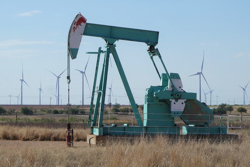
There have been commercial oil and gas wells across the United States for 170 years.  Researchers estimate that there are between two and three million wells that have been abandoned.  There are hundreds of thousands of them, across 27 states, that are “orphaned,” meaning that they are uncapped, unproductive, and nobody is responsible to manage their leakage or pollution.

Many are undocumented orphaned wells – UOWs – that are not listed in formal records and are basically out of sight and out of mind.  Besides having nobody responsible for them, nobody even knows where they are.  But they are potential sources of oil and chemical leaks into nearby water sources and can send toxic substances like benzene and hydrogen sulfide into the air. 

Researchers are using modern tools like drones, laser imaging, and advanced sensors to try to locate UOWs.  But these wells are scattered over an area of more than three million square miles.

To better predict where to look for undocumented wells, researchers are combining historical topographic maps with artificial intelligence. The US Geological Survey has scanned 190,000 topographic maps made between 1884 and 2006.  AI is being used to find the symbols for oil and gas wells on the maps.  People can recognize these symbols easily, but there are just too many maps to look at.  The problem is equivalent to finding a needle in a haystack; there is just an awful lot of hay to look through.

Abandoned wells are a big problem and it will take lots of modern technology to try to solve it.

**********

Web Links

AI Helps Researchers Dig Through Old Maps to Find Lost Oil and Gas Wells

Photo, posted August 16, 2022, courtesy of Larry Syverson via Flickr.

Earth Wise is a production of WAMC Northeast Public Radio

New York Is Sinking | Earth Wise

June 29, 2023 By EarthWise Leave a Comment

New York City is slowly sinking

The rising seas represent a threat to coastal cities across the globe.  Increasing that threat is the fact that most global cities are slowly sinking as the earth beneath them settles and groundwater is removed.   Another factor that has seldom been considered is that in major metropolises, the weight of large, concrete-and-steel skyscrapers may be hastening the sinking.

A new study by the U.S. Geological Survey published in the journal Earth’s Future estimated the weight of every building in New York City – 1.085 million of them – which they determined to add up to 1.68 trillion pounds – and estimated the downward force of those structures across the city.

The study found that buildings have a greater effect in areas that are rich in clay compared with those areas where sand or bedrock predominate.  The softer the soil, the more compression there is from buildings.  It wasn’t a mistake to build large buildings in New York, but it is important to understand that doing so pushes down the ground more and more.

The study determined that New York is sinking by around 1 to 2 millimeters each year, although some areas are sinking much faster.  The researchers say that cities must plan for future sinking, which will exacerbate the impact of rising seas. Sea levels are rising 1 to 2 millimeter each year, so the subsidence caused by the weight of buildings is equivalent to moving a year ahead in time with regard to rising ocean levels.  This is not a cause for immediate panic, but it is important to understand that this ongoing process only increases the risk of inundation from flooding.

**********

Web Links

New York City Sinking Under Weight of Skyscrapers

Photo, posted January 29, 2016, courtesy of Always Shooting via Flickr.

Earth Wise is a production of WAMC Northeast Public Radio

Arctic Methane Starting To Release | Earth Wise

November 24, 2020 By EarthWise Leave a Comment

methane is releasing from the arctic

An international team of researchers has found evidence that frozen methane deposits in the Arctic Ocean have started to be released over a large area of the continental slope off the East Siberian coast.  High levels of methane have been detected down to a depth of 1,100 feet in the Laptev Sea near Russia.

The slope sediments in the Arctic contain huge quantities of methane and other gases, known as hydrates.  Methane has a warming effect 80 times stronger than carbon dioxide over a 20-year period.  The US Geological Survey has identified Arctic hydrate destabilization as one of the four most serious scenarios for abrupt climate change.

The research team aboard a Russian ship said that most of the bubbles they observed coming up from the sea bottom were dissolving in the water, but that methane levels at the surface were four to eight times what would normally be expected.

Frozen methane deposits have been called the “sleeping giants of the carbon cycle.”  If these deposit releases were to reach a high enough level, it would be a tipping point that could greatly increase the speed of global warming.  With Arctic temperatures now rising more than twice as fast as the global average, the likelihood of a significant release of the frozen methane grows greater all the time.

Temperatures in Siberia were 9 degrees Fahrenheit higher than average from January to June this year.  Last winter’s sea ice melted unusually early.  This winter’s freeze has yet to begin, which is already a later start than any time on record.

These new discharges of methane are larger than anything found before and are a very worrisome occurrence.

**********

Web Links

Arctic methane deposits ‘starting to release’, scientists say

Photo, posted September 26, 2014, courtesy of the Office of Naval Research via Flickr. Photo credit: U.S. Navy photo by John F. Williams/Released.

Earth Wise is a production of WAMC Northeast Public Radio.

Drowning Atolls

June 15, 2018 By EarthWise Leave a Comment

https://earthwiseradio.org/wp-content/uploads/2018/06/EW-06-15-18-Drowning-Atolls.mp3

The rising seas represent an existential threat to low-lying atoll islands and that threat now appears to the more imminent than previously thought.

[Read more…] about Drowning Atolls

The Threat Of Man-Made Earthquakes

April 14, 2017 By EarthWise

https://earthwiseradio.org/wp-content/uploads/2017/03/EW-04-14-17-Man-Made-Earthquakes.mp3

According to a new report from the U.S. Geological Survey, millions of people living in Oklahoma and parts of Kansas face significant potential for damaging earthquakes this year as a result of human activity.  The only other part of the continental United States facing a similar danger is California, which has natural faults lines slicing through the state.

[Read more…] about The Threat Of Man-Made Earthquakes

Primary Sidebar

Recent Episodes

  • An uninsurable future
  • Clean energy and jobs
  • Insect declines in remote regions
  • Fossil fuel producing nations ignoring climate goals
  • Trouble for clownfishes

WAMC Northeast Public Radio

WAMC/Northeast Public Radio is a regional public radio network serving parts of seven northeastern states (more...)

Copyright © 2026 ·