• Skip to primary navigation
  • Skip to main content
  • Skip to primary sidebar

Earth Wise

A look at our changing environment.

  • Home
  • About Earth Wise
  • Where to Listen
  • All Articles
  • Show Search
Hide Search
You are here: Home / Archives for air temperature

air temperature

Rainfall and sea turtles

October 4, 2024 By EarthWise Leave a Comment

Rainfall has a major impact on sea turtles

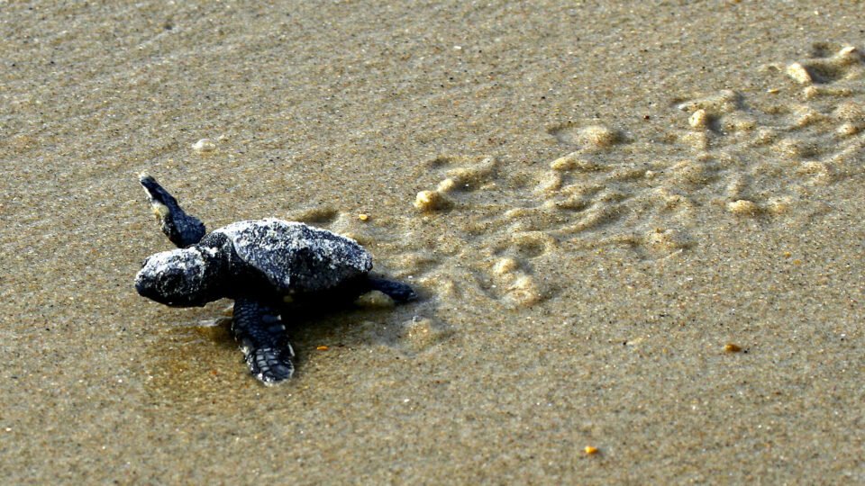
There are seven species of sea turtles that inhabit the world’s oceans. Six of the seven sea turtle species – all of them except the flatback – are present in U.S. waters, and are listed as threatened or endangered under the Endangered Species Act. 

Sea turtles, which have been around for more than 100 million years, spend the majority of their lives in the ocean, but they do periodically come ashore to nest.  Female sea turtles lay their eggs in the sand and then return to the ocean.  Survival odds for sea turtle hatchlings are quite bleak.  In fact, only one out of every 1,000 makes it to adulthood. 

Research shows that both air and sand temperatures are critical for sea turtle hatchling development.  Cooler temperatures produce larger, heavier hatchlings with more males.  Hatchling size matters because larger hatchlings, which can move faster, are more likely to survive because they spend less time on risky beaches.  But rising temperatures might shorten incubation periods, and erratic rainfall can disrupt growth, potentially affecting survival.

A new international study by researchers from Florida Atlantic University and the University of Tübingen in Germany found that fluctuating rainfall patterns have a greater impact than changes in air temperature on sea turtle hatchling development. 

The results, which were recently published in the journal BMC Ecology and Evolution, reveal that the impact of rainfall varies between species.  As climate change shifts rainfall patterns, the impact on sea turtle nesting sites suggests that global conservation strategies for some species – like loggerhead and green sea turtles – likely need to be updated.

**********

Web Links

Rain or Shine? How Rainfall Impacts Size of Sea Turtle Hatchlings

Sea Turtle

Photo, posted August 27, 2015, courtesy of USFWS/Orsulak via Flickr.

Earth Wise is a production of WAMC Northeast Public Radio

Svalbard is melting

September 10, 2024 By EarthWise Leave a Comment

Svalbard is melting

Svalbard is a Norwegian archipelago between mainland Norway and the North Pole. It is one of the world’s northernmost inhabited areas and is a popular attraction for tourists.  Svalbard is famous for rugged, remote terrain of glaciers and frozen tundra sheltering polar bears, Svalbard reindeer, and Arctic foxes. The Northern Lights are visible during winter, and its summer features the “midnight sun”—sunlight 24 hours a day.  It is the home of the Svalbard Global Seed Vault, which provides safe, free, and long-term storage of seed duplicates from all gene banks and nations around the world. 

Over half of Svalbard’s land area is covered with ice and accounts for about 6% of the planet’s glaciated area outside of Greenland and Antarctica.  But Svalbard is also one of the fastest-warming places on Earth.

It has suffered extreme episodes of melting this summer, brought on by exceptionally high air temperatures.  In late July and early August, temperatures hovered around 7 degrees Fahrenheit above average for this part of the Arctic Circle, causing snow and ice to rapidly melt.

According to scientists, Svalbard’s ice caps broke their all-time record for daily surface melt on July 23rd, shedding nearly half a foot of water equivalent that day, a rate five times larger than normal. 

On August 11th, the high temperature in Longyearbyen, Svalbard’s capital city, reached 68 degrees, the highest August temperature on record and 4 degrees above the previous monthly record.  Svalbard experienced its warmest summer on record in 2023.

**********

Web Links

Svalbard Melts

Photo, posted September 21, 2016, courtesy of Christopher Michel via Flickr.

Earth Wise is a production of WAMC Northeast Public Radio

Climate change and Antarctic meteorites

May 1, 2024 By EarthWise Leave a Comment

Researchers from Switzerland and Belgium have investigated the effects of the warming climate on access to meteorites in Antarctica.  Meteorites are of great scientific interest because they provide unique information about the makeup of our solar system.  Of all the meteorites that people have found, 62.6% of them were found in Antarctica.

Why is this?  It is not because more meteorites land in Antarctica.  Statistically, they can land anywhere on earth.  Most end up in the ocean since the world’s oceans cover 70% of the planet. 

Meteorites in Antarctica are more visible because environmental conditions are favorable for their preservation and their visibility.  The arid and cold Antarctic environment helps to preserve meteorites and the lack of rocks and contrast with ice makes spotting meteorites much easier.  The flow of ice sheets tends to concentrate meteorites in so-called meteorite stranding zones where the dark colored space rocks can be easily detected.

There are an estimated 300,000 to 800,000 meteorites in Antarctica.  When meteorites warm up, they can transfer heat to the ice, which locally melts.  Eventually, the meteorites sink beneath the surface.  A recent study using satellite imagery, climate model projections, and AI predicts that for every tenth of a degree of increase in global air temperature, an average of 9,000 meteorites in Antarctica will disappear from the surface and will no longer be able to be found. 

The study estimates that a quarter of Antarctic meteorites will be lost to glacial melt by 2050.  If warming continues to accelerate, closer to three-quarters of the meteorites on the continent will be lost. 

**********

Web Links

Climate change threatens Antarctic meteorites

Photo, posted April 21, 2005, courtesy of Kevin Walsh via Flickr.

Earth Wise is a production of WAMC Northeast Public Radio

Self-heating concrete

April 24, 2024 By EarthWise Leave a Comment

Researchers at Drexel University are developing self-heating concrete

States in the colder parts of the country spend an estimated $2.3 billion a year on snow and ice removal as well as untold millions on repairing roadways damaged by winter weather.  Researchers at Drexel University have been researching a way to extend the service life of concrete surfaces like roadways and to help them maintain a surface temperature above freezing during the winter.

Preventing freezing and thawing as temperatures go up and down and reducing the amount of plowing and salting is a desirable goal.  The Drexel team has developed a cold-weather-resilient concrete mix that is capable of melting snow on its own using only the thermal energy in the environment and not requiring salt, shoveling, or heating systems.

The system uses low-temperature liquid paraffin that turns from its room-temperature liquid state into a solid when temperatures go down.  Incorporating the liquid paraffin into concrete triggers heating when temperatures drop due to the energy released by the phase change.

Tests on slabs of the concrete on the Drexel campus over the past two years recorded 32 freeze-thaw events.  The special slabs maintained a surface temperature between 42 and 55 degrees for up to 10 hours when air temperatures dipped below freezing.

The heating is enough to melt a couple of inches of snow at a rate of a quarter inch an hour.  It’s not enough to melt a heavy snow event before plows are needed, but it can help deice road surfaces and increase transportation safety.  And simply preventing the surface from freezing, thawing, and refreezing can go a long way towards preventing deterioration.  It is promising research toward reducing an ongoing problem in colder climates.

**********

Web Links

Drexel’s Self-Heating Concrete Is One Step Closer to Clearing Sidewalks Without Shoveling or Salting

Photo, posted March 16, 2024, courtesy of Ajay Suresh via Flickr.

Earth Wise is a production of WAMC Northeast Public Radio

Little ice on the Great Lakes

March 8, 2024 By EarthWise Leave a Comment

Great Lakes missing lots of ice

In an average year, the Great Lakes end up about 40% covered in ice.  But this is not an average year.  2023 was the warmest year on record and, in fact, the global temperature was more than 1.5 degrees above the pre-industrial average for the full year.  That hasn’t happened before.  As a result of the record-breaking warmth, as of mid-February, the average ice cover on the Great Lakes was only 5.9%.

Lake Erie and Lake Ontario tied their records for the lowest ice cover, which has been tracked since 1973.  Lake Huron, Lake Michigan, and Lake Superior are at historic lows.  Some parts of the Great Lakes have experienced the winter without any ice cover.

The warming air temperatures have led to rapid ice loss and warming summer temperatures.  According to experts, if the planet continues to warm, more than 200,000 lakes may no longer freeze every winter and 5,700 lakes may permanently lose ice cover by the end of the century.

Studying the Great Lakes is important because their ice melt can be a significant indicator of the progress of global warming.  Decreasing ice cover can affect hydropower generation, commercial shipping and fishing, and have environmental impacts such as the development of plankton blooms.

Since the 1970s, there has been a 5% decline in Great Lakes ice cover per decade.  Unfrozen lakes bring more rain than snow which has environmental, cultural, and societal impacts.  The Great Lakes hold 21% of the world’s freshwater supply and over 30 million people depend on them for drinking water.  They are also linked to over $3 trillion in gross domestic product.

**********

Web Links

Great Lakes Winter Ice Cover Averaging Just 5.9%: NOAA

Photo, posted November 7, 2007, courtesy of Jim Sorbie via Flickr.

Earth Wise is a production of WAMC Northeast Public Radio

Beavers As Climate Change Fighters | Earth Wise

October 25, 2022 By EarthWise Leave a Comment

California is fighting the effects of climate change on multiple fronts.  The state has been grappling with relentless drought, record heat waves, and persistent wildfires.  The California Department of Fish and Wildlife is enlisting the help of beavers in its battle against climate change.

The state has created a beaver restoration unit charged with developing methods for nature-based restoration solutions involving beavers as well as artificial beaver dams. The agency plans to spend at least $3 million over the next two years to oversee a restoration program for the North American beaver.

A 2020 study showed that beaver-dammed corridors were relatively unharmed by wildfires compared with other areas that lacked beaver damming.  The study highlighted the differences between two adjacent corridors – one without a beaver population with a landscape scarred by a recent wildfire and another with beavers that remained a lush wetland after a fire.   The differences in burn severity, air temperature, humidity, and soil moisture between the beaver complex and the adjacent landscape were huge. 

From the 1920s through the 1950s, California actively exported beavers to other parts of the state and country so they could build dams in eroded areas where beaver dams could help evenly distribute water.  Now, the state wants to reintroduce beavers into watersheds where they once flourished.

The Department of Fish and Wildlife’s proposal to the California Legislature called beavers an important keystone species that can be used to combat climate change.   The state has spent enormous amounts of money on wildfire measures with minimal results.  Now they are going to see if beavers can make a difference.

**********

Web Links

California says the beaver can be superhero in fighting climate change

Photo, posted September 19, 2021, courtesy of Larry Lamsa via Flickr.

Earth Wise is a production of WAMC Northeast Public Radio

Climate Change And The Color Of Lakes | Earth Wise

October 19, 2022 By EarthWise Leave a Comment

According to a new study recently published in the journal Geophysical Research Letters, blue lakes around the world are at risk of turning green-brown if climate change continues unabated. 

For the study, the research team used over five million satellite images of more than 85,000 lakes and reservoirs around the globe between 2013 and 2020 in order to determine each lake’s most common water color.  Since lake color can change seasonally, the researchers assessed the most frequent lake color during those seven years. 

Algae and sediments affect the color of lakes.  But the study found that precipitation, air temperature, lake depth, and elevation also play major roles in determining a lake’s most common water color. 

The research team found that blue lakes account for less than one-third of lakes worldwide.  Blue lakes tend to be deeper and are often found in cool, high latitude regions with high precipitation and winter ice cover.  Meanwhile, green-brown lakes, which account for 69% of all lakes, are found in drier regions, continental interiors, and along coastlines. 

As global temperatures rise, lakes will warm, and warmer water produces more algal blooms.  As a result, the researchers expect the changing climate to decrease the percentage of blue lakes, many of which are found in the Rocky Mountains, northeastern Canada, northern Europe and New Zealand. 

Water color is a simple but viable way to measure water quality that can be done on a global scale using satellites.  This approach provides researchers with a way to study how lakes – even the remote ones – are changing.  

**********

Web Links

Climate change is making lakes turn green-brown

Photo, posted August 27, 2011, courtesy of Paul Schultz via Flickr.

Earth Wise is a production of WAMC Northeast Public Radio

Death Valley Flooding | Earth Wise

September 13, 2022 By EarthWise Leave a Comment

Flooding in Death Valley

Furnace Creek in Death Valley is the driest place in North America.  Its average annual rainfall is under two inches.  On August 5th, a thousand-year rainfall event dropped 1.46 inches of rain – about three-quarters of a year’s precipitation.  The all-time record for a single day is 1.47 inches, set in April 1988.  The storm did break the record for the most rain ever recorded in August, which averages just over a tenth of an inch of rain for the entire month.

The flash flood washed debris over roads, swept away and buried cars, knocked a water facility offline, damaged buildings, and stranded about a thousand visitors and staff in Death Valley National Park. By the next day, the flood water had mostly receded, and stranded visitors could be escorted out of the park by National Park personnel.

Death Valley sits at 282 feet below sea level.  If it were not for the extremely arid climate there, Death Valley would likely be filled with water.  However, humid air masses traveling east from the Pacific Ocean have to cross four mountain ranges before they reach the desert valley.  Those air masses lose their moisture in the form of rain on the western slopes of the mountain, leaving a dry area, or rain shadow, on the eastern sides.  By the time the air masses reach Death Valley, they are bone dry.  On rare occasions, the lowest spot in the valley fills with water forming a wide, shallow lake, known as Lake Badwater. 

The extreme heat and aridity of Death Valley evaporates the temporary lake quickly, returning the valley to its usual state.  Furnace Creek still holds the record for the highest air temperature ever recorded:  134 degrees Fahrenheit.

**********

Web Links

Death Valley Flash Flooding

Photo, posted April 7, 2021, courtesy of Matthew Dillon via Flickr.

Earth Wise is a production of WAMC Northeast Public Radio.

Saving The Arctic Permafrost | Earth Wise

April 17, 2020 By EarthWise Leave a Comment

Permafrost is frozen ground – a combination of soil, rock, sand, and ice – that remains at or below freezing for at least two consecutive years.  Approximately 25% of the land in the Northern Hemisphere meets this criterion, the majority of which can be found in northern Russia, Canada, Alaska, Iceland, and Scandinavia.

But as a result of the changing climate, these permafrost soils in the Arctic are beginning to thaw.  As they thaw, large quantities of greenhouse gases could be released, further accelerating climate change.  

A new study recently published in the journal Scientific Reports explores an unconventional countermeasure: resettling massive herds of large herbivores.  According to researchers from the University of Hamburg in Germany, herds of horses, bison, and reindeer could be used to significantly slow the loss of permafrost soils. 

During Arctic winters, the air temperature is often much colder than the permafrost.  Thick layers of snow can insulate the ground from the frigid air, keeping the permafrost warm (relatively speaking). But when the snow cover is scattered and compressed by the hooves of grazing animals, the insulating effect is reduced, which intensifies the freezing of the permafrost.

If climate change continues unchecked, the research team expects permafrost temperatures to rise 3.8-degrees Celsius.  This would result in half of the world’s permafrost thawing by the year 2100.  But in contrast, researchers found that the permafrost would only warm by 2.1 degrees Celsius with the resettled animals.  This 44% reduction in permafrost temperature would preserve 80% of the existing permafrost by 2100.

Natural manipulations of ecosystems could have tremendous results. 

**********

Web Links

How horses can save the permafrost

Photo, posted July 17, 2012, courtesy of Kitty Terwolbeck via Flickr.

Earth Wise is a production of WAMC Northeast Public Radio.

Predicting Lightning Strikes

November 19, 2019 By EarthWise Leave a Comment

Lightning is one of the most unpredictable phenomena in nature.  Approximately 100 lightning bolts strike earth’s surface every second, and each lightning bolt can contain up to one billion volts of electricity.  Lightning regularly kills both people and animals and sets homes and forests on fire.  It’s also been known to ground airplanes. 

Researchers at EPFL – a research institute and university in Switzerland – have developed a novel way to predict where and when lightning will strike.  The system relies on a combination of standard data from weather stations and artificial intelligence to predict lightning strikes to the nearest 10 to 30 minutes and within a radius of less than 20 miles.  The simple and inexpensive system was outlined in a research paper recently published in Climate and Atmospheric Science, a Nature partner journal.   

According to researchers, the current systems for predicting lightning strikes are slow, expensive, and complex, relying on external data acquired by satellite and radar.  The new inexpensive system from EPFL uses real time data that can be obtained from any weather station, meaning it can cover remote regions that are out of radar and satellite range and where communication networks are lacking.  The quick predictions from the system allow alerts to be issued before a storm has even formed. 

The system uses a machine-learning algorithm that’s been trained to recognize conditions that lead to lightning.  The researchers took into account atmospheric pressure, air temperature, relative humidity, and wind speed, among other things.  After training the algorithm, the system was able to predict lightning strikes accurately nearly 80% of the time.

This system is a simple way to predict a complex phenomenon. 

**********

Web Links

Using AI to predict where and when lightning will strike

Photo, posted December 14, 2018, courtesy of Flickr.

Earth Wise is a production of WAMC Northeast Public Radio.

Agrivoltaics

September 24, 2019 By EarthWise Leave a Comment

A new study by Oregon State University has found that the most productive places on Earth for solar power are farmlands.   In fact, if less than 1% of agricultural land was converted to solar panels, it would be sufficient to fulfill global electricity demand.

The concept of co-developing the same area of land for both solar photovoltaic power and conventional agriculture is known as agrivoltaics.

The synergy between agriculture and solar power is not surprising.   People have been growing crops around the planet for at least 8,000 years and, long ago, farmers found the best places to grow them which turn out to also the best places to harvest solar energy.  The needs for solar panels are pretty similar to those of food crops.  The efficiency of the panels decreases if they get too hot.  Barren land is hotter than cropland, so the productivity of solar panels is less in such places.

The Oregon State Study analyzed power production data collected by Tesla, which had installed five large grid-tied, ground-mounted solar electric arrays owned by Oregon State.  The researchers monitored air temperature, relative humidity, wind speed, wind direction, soil moisture, and incoming solar energy.  With the data, they developed a model for the best conditions for solar panel productivity and they coincide with excellent conditions for agriculture.  Solar panels are kind of like people with regard to the weather:  they are happier when it is cool and breezy and dry.

Previously-published research shows that solar panels actually increase crop yields on pasture or agricultural fields.

These new results have implications for the current practice of constructing large solar arrays in deserts.  Agricultural lands may be a much better option for both solar production and crop production.

**********

Web Links

Installing solar panels on agricultural lands maximizes their efficiency, new study shows

Photo, posted April 20, 2011, courtesy of U.S. Department of Agriculture via Flickr.

Earth Wise is a production of WAMC Northeast Public Radio.

Light Pollution And Early Spring

August 17, 2016 By WAMC WEB

https://earthwiseradio.org/wp-content/uploads/2016/08/EW-08-17-16-Light-Pollution-and-Spring.mp3

We have talked about the impact of light pollution on our ability to see stars and the Milky Way.  We have also discussed its impact on our circadian rhythms.   Recently, scientists in Great Britain published a report on the relationship between light pollution and the timing of when trees produce their buds.  The results of the study suggest that light pollution is causing plants to jump the gun on spring.

[Read more…] about Light Pollution And Early Spring

Primary Sidebar

Recent Episodes

  • An uninsurable future
  • Clean energy and jobs
  • Insect declines in remote regions
  • Fossil fuel producing nations ignoring climate goals
  • Trouble for clownfishes

WAMC Northeast Public Radio

WAMC/Northeast Public Radio is a regional public radio network serving parts of seven northeastern states (more...)

Copyright © 2026 ·