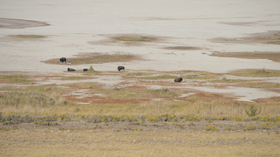
• Skip to primary navigation
  • Skip to main content
  • Skip to primary sidebar

Earth Wise

A look at our changing environment.

  • Home
  • About Earth Wise
  • Where to Listen
  • All Articles
  • Show Search
Hide Search
You are here: Home / Archives for water level

water level

The Great Salt Lake Is Disappearing | Earth Wise

August 31, 2022 By EarthWise Leave a Comment

Utah’s Great Salt Lake is the largest saltwater lake in the western hemisphere.  According to data from the US Geological Survey, the surface water elevation of the Great Salt Lake has fallen to the lowest level since records began in the mid-1800s.  The average elevation is now 4,190 feet above sea level.   With this drop in water level, the surface area of the lake is little more than half of its historical size.  The lower water level has exposed about 700 square miles of previously submerged lakebed.

The lake now contains about a quarter of the volume of water that it did at its high point in 1987.  The precipitous drop in water is a result of water usage from the lake coupled with climate change-fueled drought.   Increased water demand is due to the rapidly growing population of metropolitan Salt Lake City.  Utah’s population is projected to increase by almost 50% by 2060.

The Great Salt Lake goes though seasonal cycles of water loss and replenishment.  Rain and snow generally refill its level.  However, because of the ongoing megadrought in the West, water evaporation and depletion continue to exceed the amount of water entering the lake.  The water levels are expected to further decrease until fall or early winter, when incoming water is expected to equal or exceed evaporation.

The decline of the Great Salt Lake is a serious threat to the economy, ecology, and people of northern Utah.  The lake generates snowpack, is a refuge for hundreds of migratory birds and other wildlife and generates millions of dollars in the economy through mineral extraction and tourism.

**********

Web Links

Utah’s Great Salt Lake is disappearing

Photo, posted October 6, 2020, courtesy of Julie Girard via Flickr.

Earth Wise is a production of WAMC Northeast Public Radio.

A Record Low For Lake Mead | Earth Wise

October 4, 2021 By EarthWise Leave a Comment

The low water level of Lake Mead is causing regional water shortages

Lake Mead is the reservoir that was formed by the Hoover Dam on the Colorado River.  The lake spans the Arizona-Nevada border.  It is the largest reservoir in the United States in terms of water capacity.  The lake is part of a system that supplies water to at least 40 million people in seven states and in Northern Mexico.

As of August 22, this year, Lake Mead was filled to just 35% of its capacity.  This low water level is happening while 95% of the land in nine Western states is under some level of drought conditions and 64% of the land is under extreme drought conditions.  A so-called megadrought has been going on for 22 years and may be the worst dry spell in the region in twelve centuries.

As of the end of July, the water elevation at the Hoover Dam was 1,067 feet above sea level, the lowest it has been since April 1937 when the lake was still being filled after dam construction.  The level has dropped by 132 feet since July 2000.  At maximum capacity, Lake Mead reaches an elevation of 1,220 feet and holds 9.3 trillion gallons of water.

With Lake Mead at 35% of capacity, Lake Powell on the Colorado at 31%, and the entire Lower Colorado system at 40%, water allocations for the coming water year are being cut back. Mexico will see a 5% reduction, Nevada will be cut 7%, and Arizona will lose 18% of its apportionment.   This unprecedented official declaration of a water shortage demonstrates the severity of the drought and low reservoir conditions.

**********

Web Links

Lake Mead Drops to a Record Low

Photo, posted August 7, 2018, courtesy of Renee Grayson via Flickr.

Earth Wise is a production of WAMC Northeast Public Radio.

Rising Seas And Wastewater Leakage | Earth Wise

April 28, 2021 By EarthWise Leave a Comment

Rising seas will further damage coastal wastewater infrastructure

Global mean sea level has risen nearly 9 inches since 1880, with over two inches of that over just the last 25 years.  The rising water level is primarily due to two factors:  additional water in the oceans coming from melting glaciers and ice sheets; and the thermal expansion of seawater as it warms.  Climate models estimate that over the course of the century, global sea levels will rise at least a foot even if efforts to reduce greenhouse gas emissions are quite successful and, in the worst case, levels could rise as much as 8 feet.

Faced with this situation, the greatest concerns are, initially, increasing amounts of coastal flooding and erosion and, as things get worse, inundation of coastal regions making many places uninhabitable and creating millions of climate refugees.

Recently, computer modeling studies have focused on an additional imminent problem:  the flooding of coastal wastewater infrastructure, which includes sewer lines and cesspools.

A new study by the University of Hawaii at Manoa is the first to provide direct evidence that tidally driven groundwater inundation of wastewater infrastructure is already occurring in urban Honolulu.  The study shows that higher ocean water levels are leading to wastewater entering storm drains and the coastal ocean.  The result is degradation of coastal water quality and ecological health.

The researchers used chemical tracers to detect groundwater discharge and wastewater present at multiple low-lying areas during spring tides.  During high tides, storm drains become channels for untreated wastewater to flood streets and sidewalks. 

People tend to think of sea-level rise as a future problem, but there are already serious effects going on today that are only going to get worse.

**********

Web Links

Sea-level rise drives wastewater leakage to coastal waters

Photo, posted August 23, 2011, courtesy of Eric Tessmer via Flickr.

Earth Wise is a production of WAMC Northeast Public Radio.

The Caspian Sea And Climate Change | Earth Wise

January 22, 2021 By EarthWise Leave a Comment

Climate change will lower water levels in the Caspian Sea

According to the National Oceanic and Atmospheric Administration, global sea levels have been rising over the past century, and the rate has increased in recent decades.  Sea levels are currently rising about one-eighth of an inch every year.

Sea level rise is caused primarily by two factors related to climate change:  the added water from melting glaciers and ice sheets, and the expansion of seawater as it warms.  While climate change is causing global sea levels to rise, higher temperatures in other regions are having exactly the opposite effect.  The water levels are falling.

According to researchers from the University of Bremen in Germany, the Caspian Sea is a perfect example of how a body of water will change.  While it is named a sea due to its size and high salinity, the Caspian Sea is actually a lake.  In fact, it’s the largest lake in the world.  Its largest inflow is the Volga River and it has no natural connection to the ocean.  Its water level is determined by the proportional influences of inflow, precipitation, and evaporation.  Climate change is causing increased evaporation, which leads to a declining water level. 

According to the research team, the water level of the Caspian Sea could fall by 29 to 59 feet during this century.

The Caspian Sea is surrounded by Kazakhstan, Turkmenistan, Iran, Azerbaijan and Russia.  It’s an important regional water reservoir, and a biological and commercial center. 

The researchers hope the Caspian Sea will be used as an example in scientific research to assess the vulnerability of other regions to falling water levels.

********** 

Web Links

Climate crisis is causing lakes to shrink

Photo, posted October 31, 2016, courtesy of Amanderson2 via Flickr.

Earth Wise is a production of WAMC Northeast Public Radio.

Conserving The Colorado River | Earth Wise

August 13, 2020 By EarthWise Leave a Comment

Colorado River Water and Climate Adaptation

Last year, we talked about the troubles facing the Colorado River.  Nearly two decades of drought conditions have reduced the water levels of the two largest reservoirs of Colorado River water and have threatened the water supply of millions of people in the region.  Clear scientific evidence shows that climate change is constricting the iconic river and will do further damage as temperatures rise.

Faced with these facts, water resource managers have been implementing conservation policies in the region and the results so far are very encouraging.

The use of Colorado River water in the three states of the river’s lower basin – Arizona, California, and Nevada – fell to a 33-year low in 2019.  The three states consumed just over 6.5 million acre-feet for the year, which is about 1 million acre-feet less than the three states are entitled to use under the legal agreement that allocates Colorado River water.

The last time water consumption from the river was that low was in 1986, which is the year that Arizona opened a large canal that extracts river water for its entitlement. 

A key indicator of river health is the depth of Lake Mead, the largest reservoir of Colorado River water.  It has been steadily dropping in recent years, but last year, with the reduced consumption, the water level actually increased by 12 feet.

According to water managers, the steady drop in water consumption in recent years is a sign that conservation efforts are working and that there are strategies that can deal with chronic shortages on the river in the future.  It represents an important demonstration that it is possible to use less water in a region that irrigates 5 million acres of farmland and has 40 million people in 2 countries and 29 tribal nations.

**********

Web Links

Remarkable Drop in Colorado River Water Use a Sign of Climate Adaptation

Photo, posted July 7, 2015, courtesy of Flickr.

Earth Wise is a production of WAMC Northeast Public Radio.

Primary Sidebar

Recent Episodes

  • Dangers Of Melting Glaciers | Earth Wise
  • How To Meet Protected Land Targets | Earth Wise
  • Sustainable Jet Fuel | Earth Wise
  • Protecting Wetlands | Earth Wise
  • Offshore Wind Industry In New York | Earth Wise

WAMC Northeast Public Radio

WAMC/Northeast Public Radio is a regional public radio network serving parts of seven northeastern states (more...)

Copyright © 2023 ·