• Skip to primary navigation
  • Skip to main content
  • Skip to primary sidebar

Earth Wise

A look at our changing environment.

  • Home
  • About Earth Wise
  • Where to Listen
  • All Articles
  • Show Search
Hide Search
You are here: Home / Archives for miami

miami

The East Coast is sinking

March 11, 2024 By EarthWise Leave a Comment

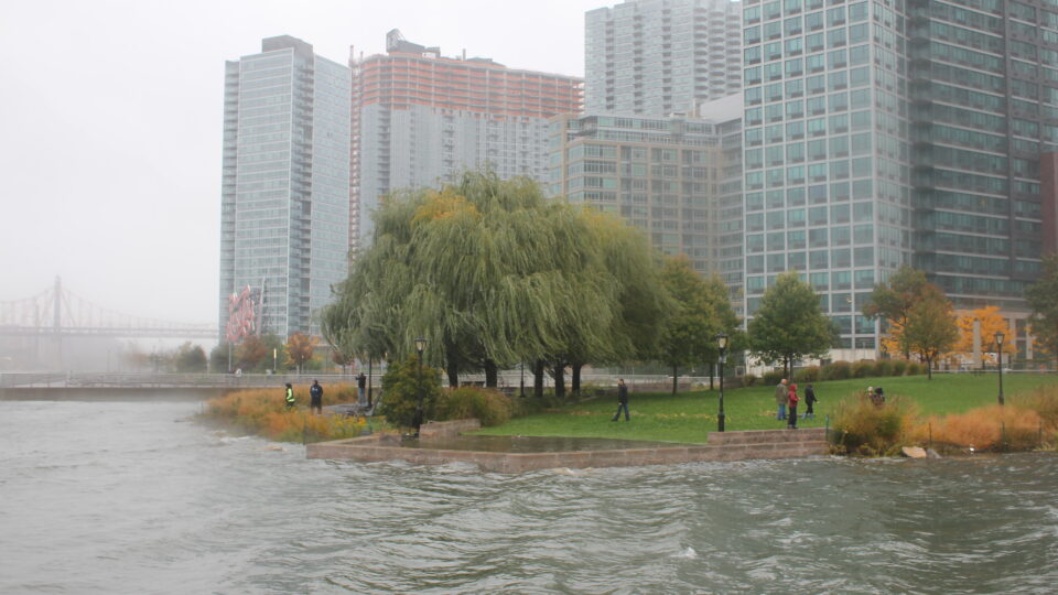
Most of the world’s largest cities are located in coastal regions and coastal regions are on the front lines of the climate crisis.  Human populations continue to migrate towards low-elevation coastal areas at the same time that sea level rise is accelerating.  Coastal communities worldwide are increasingly vulnerable to the dangers of flooding and erosion.  With these hazards occupying a great deal of attention, there has been less attention paid to the dangers of land subsidence.

A recent study by researchers at Virginia Tech and the US Geological Survey using satellite data shows that parts of America’s east coast are sinking, and the culprit is the withdrawal of too much water from the aquifers beneath these coastal areas.

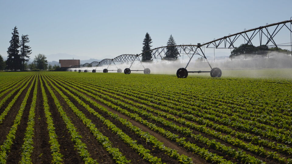
A series of overlapping aquifers extends all the way from New Jersey to Florida along the coast, providing a reliable source of water for drinking, irrigation, and industrial uses.  Even though these areas get regular rainfall, the deeper aquifers can take hundreds or even thousands of years to refill once water is pumped out.  Once water is removed, soils can compress and collapse, causing the land surface to sink.

Cities that were built on drained marshland or on fill soil are especially vulnerable to compaction. 

Seal level rise is slow, but it is insidious and continuous.  Add land subsidence to the mix and effects multiply.  Places like Boston, New York, Washington DC, Roanoke, Savannah, Jacksonville, and Miami, among others, all are increasingly vulnerable to these coastal hazards.  The combined effects of sea level rise and subsidence may even triple the prospects for flooding areas over the next few decades.

**********

Web Links

As Aquifers Are Depleted, Areas Along The East Coast Of The US Are Sinking

Photo, posted August 7, 2015, courtesy of Tracy Robillard / NRCS Oregon via Flickr.

Earth Wise is a production of WAMC Northeast Public Radio

New York is raising its shoreline

January 18, 2024 By EarthWise Leave a Comment

Superstorm Sandy in 2012 flooded 17% of New York City and caused $19 billion in damage.  In its aftermath, plans emerged to create floodwalls, raised elevations, high-capacity drainage, and other infrastructure to protect the city from future Sandy-like events.

Like all large infrastructure projects in densely populated places, the remaking of New York’s shoreline has only moved along in fits and starts.  But there has been significant progress.

The East Side Coastal Resiliency (ESCR) project is the largest urban resiliency project currently underway in the United States.  The first piece of it – the Asser Levy renovation – was completed in 2022.  Over the next three years, the $1.8 billion ESCR will reshape two-and-a-half miles of Lower Manhattan’s shoreline.  The ESCR is just one part of a much larger $2.7 billion initiative called the BIG U, which is a series of contiguous flood resilience projects that will create 5.5 miles of new park space specifically designed to protect over 60,000 residents and billions of dollars in real estate against sea level rise and storm surges. 

In a time of rising seas and increasingly powerful storms, flood-prone coastal U.S. cities – including Boston, Norfolk, Charleston, Miami, and San Francisco – are moving toward embracing the long-held Dutch concept of “living with water”, which emphasizes infrastructure that can both repel and absorb water while also providing recreational and open space.

**********

Web Links

After a Decade of Planning, New York City Is Raising Its Shoreline

Photo, posted November 1, 2012, courtesy of Rachel via Flickr.

Earth Wise is a production of WAMC Northeast Public Radio

Keeping Charleston Dry | Earth Wise

June 11, 2020 By EarthWise Leave a Comment

Rising seas from climate change

Charleston, South Carolina is visited by millions of tourists each year.  The town is a glimpse into the past, showcasing antebellum mansions, row houses, historic African American churches and scenic harbor views from a Civil War-era promenade.

Charleston is also visited more and more by water from rising seas and increasingly powerful storms.  The city is essentially drowning in slow motion and may soon face an existential threat to its survival.

Charleston has a harbor and three rivers and water from all these sources leaks in at every bend and curve, fills streets, disrupts businesses, and rushes into homes during storms.  Million-dollar antebellum mansions, built on spongy marsh and old tidal creeks, flood repeatedly.

City officials have endorsed a plan by the U.S. Army Corps of Engineers to wall off the historic downtown with an 8-mile-long seawall that would cost nearly $2 billion.  The proposed barricade is just one of many proposed projects to build seawalls, surge gates, levees, and other barriers to defend U.S. coastal cities in an era of rising seas and climate-fueled floods and storms.  A proposed flood wall in Miami would cost federal taxpayers $8 billion.

Researchers generally agree that sea levels are likely to rise by at least 3 feet by the end of the century.  Some experts believe the rise will be much greater.  So, a key question is whether these barriers will actually keep out the water.  Critics of many of the proposed solutions contend that they are doomed to fail.

Flooding has caused nearly $1 trillion worth of damage along the East and Gulf coasts over the past 40 years.  And things are almost certain to get worse in Charleston and other coastal cities.

**********

Web Links

Fortress Charleston: Will Walling Off the City Hold Back the Waters?

Photo, posted October 7, 2015, courtesy of Jeff Turner via Flickr.

Earth Wise is a production of WAMC Northeast Public Radio.

Off-The-Charts Heat

August 9, 2019 By EarthWise Leave a Comment

There have been some blistering heatwaves this summer – in Europe, in the Middle East, and here in the United States.  A new report by the Union of Concerned Scientists projects that within the next 20 years, millions of people in the United States could be exposed to dangerous “off-the-charts” heat index conditions of 127 degrees Fahrenheit or more.  Within 60 years, over one-third of the population could be exposed to such conditions.

Extreme heat kills hundreds of people every year across the U.S.  Our bodies’ natural cooling process is affected by humidity and the combined heat index measures the impact of high temperature and high humidity.  When the combined heat index reaches 90 degrees, it is considered to be a “dangerous day”, when many groups of people are at serious risk.

Because of the warming climate, the number of dangerous days has been increasing in many parts of the country.  Unless there is success in limiting the effects of climate change, by 2050, even relatively temperate cities like Detroit, Minneapolis, New York, and Chicago will have 50 or more dangerous days a year.  Places like Dallas, Houston, Phoenix and Miami will experience dangerous days for half of the year.

The National Weather Service’s heat index goes up to 127 degrees Fahrenheit.  But in as soon as 20 years, the Southeast, Southern Great Plains, and Midwest will begin to experience days that are so hot that they are “off the charts.”

These extreme conditions could still be avoided with steep, rapid carbon emission reductions.  But however successful we are going forward, the US will still be significantly warmer than today with 85 urban areas exposed to 30 or more days with a heat index above 105 degrees, compared with just three urban areas historically.

**********

Web Links

‘Off-the-charts’ heat to affect millions in U.S. in coming decades

Photo, posted August 8, 2008, courtesy of Flickr.

Earth Wise is a production of WAMC Northeast Public Radio.

Examining Sea Level Rise

January 17, 2019 By EarthWise Leave a Comment

It’s no secret that sea levels along the East Coast of the United States are rising.  But what’s less known is that the water isn’t rising at the same rate everywhere.  As the climate continues to change, some cities may remain dry while others struggle to keep water out. 

During the 20th century, sea levels rose about 18 inches near Cape Hatteras in North Carolina and along the Chesapeake Bay in Virginia.  During that same time period, New York City and Miami experienced a 12 inch sea level rise, while the waters near Portland, Maine only rose 6 inches.  According to a study recently published in the journal Nature, there’s an explanation for this. 

The variation is a result of a phenomenon called “post-glacial rebound.”  During the last ice age, huge sheets of ice once covered land areas in the Northern Hemisphere, including parts of the Northeast U.S.  The weight of the ice weighted down the land like a boulder on a trampoline.  At the same time, peripheral lands such as the U.S. mid-Atlantic coast rose up.  As the ice melted, the previously weighted-down regions rebounded while the peripheral lands began to sink.  While these ice sheets disappeared some 7,000 years ago, this see-sawing of post-glacial rebound continues to this day. 

Researchers combined data from GPS satellites, tide gauges, and fossils in sediment with complex geophysical models to produce this comprehensive view of sea level change since 1900.  While post-glacial rebound accounts for most of the sea level variation along the East Coast, researchers noted that when that factor is stripped away, “sea level trends increased steadily from Maine all the way down to Florida.”

**********

Web Links

Why is sea level rising faster in some places along the US East Coast than others?

Photo, posted August 24, 2014, courtesy of Bill Dickinson via Flickr.

Earth Wise is a production of WAMC Northeast Public Radio.

Climate Change And Heat Waves

February 3, 2017 By EarthWise

https://earthwiseradio.org/wp-content/uploads/2017/01/EW-02-03-17-Climate-Change-and-Heat-Waves.mp3

2016 was the hottest year on record and saw many extreme weather events.   How much of what happened resulted from climate change has yet to be assessed.  However, the analysis of 2015 – which was the hottest year on record up until last year – has been presented in a special publication by the American Meteorological Society.

[Read more…] about Climate Change And Heat Waves

Primary Sidebar

Recent Episodes

  • An uninsurable future
  • Clean energy and jobs
  • Insect declines in remote regions
  • Fossil fuel producing nations ignoring climate goals
  • Trouble for clownfishes

WAMC Northeast Public Radio

WAMC/Northeast Public Radio is a regional public radio network serving parts of seven northeastern states (more...)

Copyright © 2026 ·